 Neighbor Todd Campbell says that as of August 14th, 2021, our 36 Teresita bus is back to its normal 30-minute schedule (after the Covid pandemic re-routing earlier).
@@|@@
@@@|@@@
|
|
|
|
Neighbor Todd Campbell says that as of August 14th, 2021, our 36 Teresita bus is back to its normal 30-minute schedule (after the Covid pandemic re-routing earlier).
@@|@@
@@@|@@@
|
|
|
|
 By request, I am reprising this post that lets everyone know how to stay connected with our neighborhood on the Internet. It’s been slightly edited and updated.
There are several ways to connect to what’s happening in our neighborhood.
1. NextDoor Forest Knolls
Right now, Nextdoor is probably the most active platform (which I wrote about HERE). It’s different from the Yahoo Group in that you need to give your actual name and address (and NextDoor will verify the address). It’s the opposite of anonymity. The idea is to facilitate the building of community and trust. There are group leaders who can act if someone seems to be violating community norms. I’m one for Forest Knolls. So far, there’ve been no problems.
It’s relatively private, in that only others on NextDoor will see it. It won’t show up on a Google Search, for instance. But I’d warn that it’s private, not confidential. There’s no way of knowing who might copy or forward your post to someone else. Also, over time people who move away might not bother to change the details on their Nextdoor account unless they want to set up a new account where they’ve moved.
If you use the “Nearby Neighborhoods” feature, it gives access to  Nextdoor in 10 other neighborhoods. That means when you post something on Nextdoor, you can decide whether to post it just to Forest Knolls, or to the whole bunch of neighborhoods. (If you post to all the nearby neighborhoods as well, around 4800 people could see your post.)
You can turn off some of the neighborhoods if they are not really of interest. People have been using it for things like recommendations for contractors, baby-sitters, household stuff for sale, announcements of neighborhood or commercial events – and warnings about crime and other safety issues. It’s a good way to meet up with others who have similar interests, say, for instance, small kids.
If you’d like to join, that link is HERE
2. This website and blog, www.ForestKnolls.info (not dot com or dot org ! dot INFO)
This runs stuff of general interest, occasional pictures and articles, and announcements. It’s a good place for laying out or updating any neighborhood issues. It’s completely public – anyone anywhere with internet access can read it (should they want to).
It’s got a Pets page, so if you’d like to add a picture of any Forest Knolls pet to it, send it in to fk94131@yahoo.com – with the name of the animal if you want it included. So far, we only have dogs and cats, but I’m completely open to pictures of iguanas or macaws or even the odd tarantula. Send them in!
If you want to stay updated whenever there’s a new post, you can subscribe to the site for emails. (Go HERE and enter your email address in the box on the right side.) Your email does not become public, but the Webmaster can see it.
3. The Forest_Knolls_Neighborhood Yahoo Group.
Anyone can join, though it’s really of interest to people within the Forest Knolls neighborhood. It’s managed by Mary Allen. You can give your actual name or not as you prefer. Your email address will be visible. It’s also public, but people are unlikely to search it out. They could if they wanted, though.
Here’s what I wrote about it with instructions for joining:
“This is a free group. Anyone can join, though of course its greatest value is to people in the neighborhood. And, as groups go, it’s civilized. I’ve seen groups where participants forget they’re in a public space, and start flame-wars or post overly personal information. This is not that kind of group.”
If you’d like to join that, the link is HERE. Look for the button that says “Join This Group!”
4. Forest Knolls Group on Facebook
Anyone who’s on Facebook can join, but you have to ask the administrator (right now, that would be me). I’d love for more people to join and post stuff. It’s a good place to share pictures or anything you like. It’s public to anyone on Facebook.
Here’s the link:

WHAT SHOULD I JOIN?
What you decide to join really depends on how you want to use it.
For myself – I’m on all of them. It’s neat that our neighborhood can be connected on the web. I hope more people join in – spread the word!
Recently, Danh Tran of the web-based real estate company Trulia (acquired earlier this year by Zillow) reached out to me with an interesting map. It showed noise complaints across San Francisco for 2010-2013 as an animation. Would I care to share it with our readers?
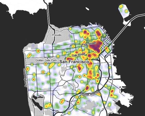
This is a screenshot for December 2013, the latest data they have. What this shows is where people call the police to complain about noise. The color coding is self-evident – green shades to yellow shades to red as the density of noise complaints rises.
The animation is available at this link on the Trulia website. It starts with Feb 2010 and cycles to December 2013 and back.
San Francisco’s noise complaint levels vary a lot: Here’s a screen-shot from October 2013. There’s a lot more red in this one!
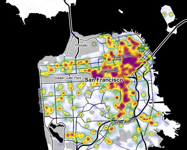
Trulia’s Peter Black has made a similar analysis of several cities, including New York and Seattle. But the methodology he’s used for San Francisco is slightly different.
Why does San Francisco only have data through 2013? I asked. Simply – it looks like no one is compiling the data any more. Or if they are, it’s not easily available.
“In regards to the date, the reason for that is Peter couldn’t find any data for SF from the normal, open sources (311 calls) like he did for NYC and Seattle. Instead, he pulled it from our (Trulia) crime database. Unfortunately, and for no known explained reason, the noise complaints simply disappear from the data in 2014.”
Regardless, the data clearly show what we know already: We live in a tranquil neighborhood. Here’s the [December 2013] noise complaints map for Forest Knolls (thanks, Danh Tran). Not a spot of red in sight.
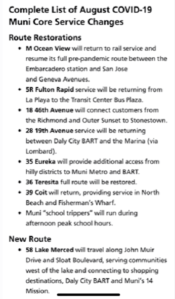
I just got an email from the SFMTA with updates to proposed route changes. “Your participation has made a difference!” it said. It continued with an explanation of the changes proposed by the Policy and Governance Committee (PAG).
Among them: “36 Teresita: The PAG supports maintaining the entirety of the existing 36 alignment.”
Thanks, everyone who spoke up, commented, and wrote in against the original plan and particularly to those who spearheaded this effort. Clearly, our voices were heard.
[Special thanks also to our District 7 Supervisor, Norman Yee, for his assistance.]
Here’s the text of the whole message, in case you’re interested in other routes. There’ll be a meeting on March 28th, 8 a.m. at City Hall during which the final decision will be made. It’s expected to be in line with the recommendations.
Your participation has made a difference!
The service change proposals of the Transit Effectiveness Project, an ongoing project to make Muni more reliable for its customers, were reviewed by the SFMTA Policy and Governance Committee (PAG) on Friday, March 21. Based on their input, staff is recommending the following proposal modifications outlined below. Staff will present the following recommendations to the SFMTA Board on Friday, March 28. These modifications aim to retain the benefits of the initial proposals, while addressing key community concerns.
Here’s what we proposed, what we modified based on what we heard, and what we will be recommending to the SFMTA Board:
2 Clement: The PAG supports the recommended proposal of using existing overhead wires to implement 2 Clement trolley service on the entire Sutter/Post Street corridor, adding service on the Sutter Street route segment, and realigning the 2 line to operate on California Street to Eighth Avenue, on Eighth Avenue south to Clement Street, on Clement Street between Eighth and Sixth Avenues, and to California via Sixth Avenue. Service will be discontinued on Clement Street; between Arguello Boulevard and 6th Avenue, and 8th and 15th Avenues.
3 Jackson: The PAG supports maintaining service on the 3 Jackson with reduced frequency to better match customer demand.
6 Parnassus: The PAG supported maintaining the 6 Parnassus in the line’s current alignment through Ashbury Heights to UCSF and Golden Gate Heights and to reduce the frequency of the line to better match customer demand west of Masonic Avenue. Service will be further increased on the 71L Haight/Noriega Limited.
8X Bayshore Express: The PAG supports the continuation of 8X service north of Broadway for every other trip.
10 Townsend: The PAG supports the current 10 Townsend (Sansome) proposal to reroute through Mission Bay.
17 Parkmerced: The PAG supports the revised 17 realignment proposal, which shifts service to portions of Lake Merced Boulevard and Brotherhood Way to access the Daly City BART Station.
22 Fillmore and 33 Stanyan: The PAG supports the original realignment proposals for these routes, which include realigning the 22 along 16th Street to provide a direct transit connection to Mission Bay and realigning the 33 Stanyan off of Potrero Avenue and along the former 22 Fillmore alignment into the Dogpatch neighborhood. The PAG also supports increasing 33 service from 15 minute service to 12 minute service all day.
27 Bryant: The PAG supports maintaining the entirety of the existing 27 alignment.
28/28L 19th Avenue: The PAG supports the revised proposal for the 28 and 28L, which calls for the termination of the 28L in the Richmond District to Park Presidio and California Street and extension to the Balboa Park BART Station and the Mission corridor, as well as the continuation of the 28 to the Marina District via the Golden Gate Bridge to a new terminal at Van Ness Avenue and North Point Street.
35 Eureka: The PAG supports the revised proposal for the 35, which includes the continuation of service on Moffitt, Farnum, Addison, and Bemis Streets, and the extension of service to the Glen Park BART Station via Miguel and Chenery Streets.
36 Teresita: The PAG supports maintaining the entirety of the existing 36 alignment.
43 Masonic: The PAG supports connecting the route with the Presidio Transit Center while maintaining the existing route segment on Letterman Drive and Lombard Street.
47 Van Ness: The PAG supports maintaining 47 line service on 11th Street between Mission and Bryant Streets, rather than on 13th Street as originally proposed.
48 Quintara/24th Street: The PAG supports the original 48 service change proposal to remove service in the vicinity of Hoffman and Grandview Streets and instead straighten service along Clipper and Douglass Streets. However, the PAG supports maintaining the 48’s current alignment until the new 58 24th Street route is introduced, which is proposed to serve the former 48 alignment along Douglass Street, 21st Street, and Grandview Avenue.
56 Rutland: The PAG supports maintaining the entirety of the existing 56 alignment.
What’s next? See your input in action!
Proposed service and route changes to be reviewed by SFMTA Board of Directors at the following upcoming public hearings at City Hall Room 400, 1 Dr. Carlton B. Goodlet Place
Friday March 28, 2014 at 8am
TEP Service change recommendations will be presented. (SFMTA board will make decisions at this meeting)
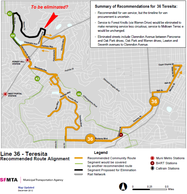
A few weeks ago, I wrote about SF MTA’s plans to leave our steep and hilly area without public transportation by dropping the Forest Knolls loop of the 36-Teresita bus. (And this is after the previous battle to save this line, which ended with frequency being reduced from 20 minutes to 30.) Neighbors have been fighting this plan. The Forest Knolls Neighborhood Organization has joined the battle to save the bus route, and has some great suggestions about how you can help. Here’s their flyer:
FOREST KNOLLS NEIGHBORHOOD ORGANIZATION
MUNI plans to eliminate the Forest Knolls loop of our 36 Teresita bus.
Proposed service and route changes will be reviewed by SFMTA Board of Directors at a public hearing this Friday March 14, 2014 at 9am in City Hall, room 400.
TEP Informational Hearing – staff will present proposals from feedback gathered at recently held community meetings. The SFMTA Board will then take additional testimony from the public on proposed route changes.
It is important that Forest Knolls residents appear at this hearing to make known their strong objection to the proposed elimination of MUNI service to our Forest Knolls neighborhood.
Please plan to attend the meeting this Friday March 14 at 9 am in City Hall, room 400.
The SFMTA Board responds to community participation – we must be present in large numbers to voice our objections. Plan to attend this important hearing if at all possible.
E-mail your opposition to http://www.tellmuni.com and tweet SFMTA (@sfmta_muni) to make your opposition known. Also e-mail your opposition to the Planning Manager of MTA’s “Transit Effectiveness Project” Sean Kennedy: sean.kennedy@sfmta.com and call our supervisor (Norman Yee) at 415-554-6516 to seek his assistance.
Meanwhile, neighbors have been talking to the SF MTA – which seemed responsive, but has not published any planned changes (which it has made to its plans for other routes). Here’s what Joe Humphreys wrote to update us:
The SFMTA had a public meeting on February 25th at San Francisco State. Forest Knolls was well represented with a number of neighborhood residents raising substantial protest to rerouting the 36 line to no longer include Warren Drive. It appeared at the meeting that the SFMTA staff understood and were sympathetic to the concerns raised. However, they announced today a number of changes that they had made to the staff’s proposed “Transit Effectiveness Plan” Apparently, however, what they are recommending does not include keeping bus service in Forest Knolls as the 36 line is not one of those where they indicated some accommodation to public concerns. This announcment is here : http://sfmta.com/news/project-updates/tep-service-change-proposals-revised-based-community-feedback .
The West of Twin Peaks Central Council – which is a “Council of councils” comprising twenty different neighborhood organizations, passed a Resolution in Support of the 36-Teresita.
A Resolution in Support of the 36-Teresita
By: The West of Twin Peaks Central CouncilPASSED UNOPPOSED
WHEREAS, It is clear that the San Francisco Muni is looking to cut or severely curtail service on the 36-Teresita Bus line in their upcoming budget meeting: and
WHEREAS, there have 6 independent West of Twin Peaks Central Council Member Neighborhoods [The Woods, Galewood Circle, Forest Knolls, Midtown Terrace, Mount Sutro Woods and Sherwood Forest] on steep hillsides that depend exclusively on the 36-Teresita as the only Muni connection to the rest of the city and the Bay Area: and
WHEREAS, these neighborhoods are filling up with new families with children that need the 36-Teresita to get them to and from school: and
WHEREAS, the elderly residents of these neighborhood depend on the home health care workers that come to them via the 36-Teresita Bus to make it possible for them to stay in their homes for as long as is possible:
Now, therefore,
BE IT RESOLVED: that the West of Twin Peaks Central Council assembled this 24th
day of February, 2014, in the City of San Francisco, California, urges the Muni to see the immense value that the 36-Teresita Muni bus line contributes to the residents, visitors, commerce, and children of the above mentioned neighborhoods and the city as a whole: and
BE IT FURTHER RESOLVED that the Muni should keep the current 36-Teresita service available to these taxpayers who crowd this line at commute times and depend on it as a lifeline in this increasing congested city.
We hope that SFMTA is listening. Please attend the meeting if you can, and also send in your comments to tellmuni.com, to sean.kennedy@sfmta.com, and to our District 7 Supervisor Norman Yee.
About a year ago, Joe Humphrys warned us that the SFMTA was planning to abandon the Forest Knolls section of the 36 Teresita bus service. I wrote about that HERE, and Joe contributed a post HERE.
So, it’s happening, unless the neighborhood manages to get SFMTA to re-think this. The public hearing is on Feb 25th, 2014. (I got another message from Joe, with a link to the public hearing notice.)
Date: Feb 25th,
Time: 6 p.m.
Where: San Francisco State University,
Seven Hills Conference Center,
800 Font Blvd., San Francisco, CA 94132
And then Sara Lu wrote a note. This is important, because clearly if anything is going to change, it will need to come from neighborhood pressure. Otherwise, our bus is gone. Here’s her note (with minor edits and added emphasis):
Dear Web Master,
The posted route 36 notice at the bus stop caught my attention; and I looked into the details. Here is what I found: http://www.sfmta.com/sites/default/files/projects/rte_036_BW.pdf
[Webmaster: This is similar to the map at the top of this post, available as a PDF here: rte_036_BW]
Muni proposed to change route 36 by eliminating stops include Clarendon Avenue between Panorama and Oak Park drives, Oak Park and Warren drives, Lawton and Seventh avenues to Clarendon Avenue. This means no bus will come through Forest Knoll at all, which is completely unacceptable.
I sent in my objections on Muni’s website (http://tellmuni.com); but a singular post is not going to make the difference – we will need as much neighborhood support as possible. I strongly recommend posting the subject on the Forest Knoll website and throughout the neighborhood, encouraging as many residents to attend the public hiring on Feb 25 (6pm) and post on tellmuni feed back as possible.
(public hearing details: http://www.sfmta.com/zh-hant/calendar/meetings/community-meeting-proposed-service-changes-routes-17-18-28-28l-36-and-43)
I am a daily rider on the 36 bus from Devonshire and Warren drive. Route 36 is the only form of public transit through the Forest Knoll neighborhood. For daily commuters like myself and the many elderly residents in the neighborhood, it is the only form of connection to Forest Hill Muni station. A 30-minute bus frequency is already inconvenient enough; eliminating the route through Forest Knoll is completely unacceptable. It will leave the entire community stranded, without any feasible form of public transportation.
The proposed alternative is not at all realistic. Walking to 7th and Lawton or Clarendon may not seem terribly far on flat map; but anyone who knows the area topography would know, the Forest Knoll neighborhood is on a very steep hill. In fact, it is one of the highest points in San Francisco. It is impossible for any elderly resident to talk from the proposed alternative stops (20-30 minutes straight uphill); and completely impractical for daily rider like myself. I, as well as most residents, cannot afford to drive and park in downtown San Francisco, and have no intention to add to the congestion on the road.
I am trained as an urban planning, and fully support public transportation. Leaving a whole neighborhood/community without any form of accessible public transportation is not acceptable.
What would you propose we can do to make sure our neighborhood is not overlooked?
The only way to stop this is to protest. As Sara Lu points out, a few posts will not make a difference, but a whole lot will.
Season’s Greetings to everyone who’s reading this, and a Happy New Year in 2014!
This website and blog is just over four years and 300 posts old. It was partly meant to give Forest Knolls a web presence; partly to give it a public voice.
I’ve found that writing about this neighborhood really makes me appreciate it. Please feel free to join in – send photographs, make comments, write about things you’d like to share. Onward to Year Five!
My evening walks are getting deliciously Halloween-flavored.
What better phase of the moon for an eerie picture than a waxing crescent?

(I found out quite late that if the moon is ‘D’ shaped, it’s waxing, and if it’s ‘C’-shaped, it’s waning. The mnemonic is ‘Dogs advance, Cats retreat.’ But it only works in the Northern hemisphere; Down Under, it’s the other way.)
Here’s the moon and Venus, taken a night or two later. [Edited to Add: Looking closely at this picture again, I can just see the Old Moon in the New Moon’s arms – the earthshine on the non-illuminated part of the moon. The Wikipedia says it’s light reflected from earth onto the moon.]

I was on Tank Hill recently, where I always take photographs even though very few actually come out. This time, though, with a little brightening of the image and upping the contrast, I got these Halloween trees.
 Last night, I didn’t encounter a single dog-walker – but, appropriately, there were two cats. Here’s one:
 And here’s the other – don’t miss the Halloween eyes. (Okay, it’s normal eyeshine, but it looked cool!)

And some neighbors have started putting up their Halloween decorations, like this happy family of jack o’ lanterns. Looking forward to seeing more decorations as we get closer to the date!

Michaela Byrne, who lives in our neighborhood, sent in this photograph with a lovely tribute to our weather. Her website is at michaelabyrne.wordpress.com

The fog has been rolling in this week in great white sheets, rolling over the hills. My neighborhood has such a tangible relationship with fog. We embrace each other, work into the depths of each other. Fog swirls around our streets and wisps through the corner of our chain link fences. Sunlight fights the buildings to reclaim its hill top territory, and the fog races through the terraces, desperate to flee. Forest Knolls, Crestmont Street, Diamond Heights, Golden Gate Heights, we are the first thing the fog truly touches when it rolls in from the ocean. We provide the surfaces and the touch for mist to coalesce, dropping off the moisture gathered a thousand miles away. We are the islands where blue butterflies still roam, the sanctuaries for coyotes and the smell of eucalyptus dust, foxes and jasmine. And we are also the final resting place of San Franciscan latitude fog.
The bright Noe, Castro, Mission owe these standing hills a debt of gratitude. We pay with our drenched sweaters and drenched in sweat climbing to our ear-popping homes to enjoy a view that fifty percent of the time is erased from sight by fog the color of a blank page, like an erased world, so that those bright districts can have shadows and open air cafes. We are the inhabitants of this cool piece of landscape.
– Michaela Byrne
The article below is republished with permission from Outsidelands (with some added emphasis). Click HERE for the original article. I want to thank Rex Bell for a wonderful step back in time.
———————————–
A WALK ALONG THE ALMSHOUSE ROAD:
A Historical Description of Today’s Clarendon Avenue
by Rex Bell
I’ve always been fascinated with San Francisco history. To indulge my interest, I sometimes try to imagine what areas of the City I’m so familiar with were like in the past. I recently got a little help when I discovered a detailed, descriptive article that appeared in the San Francisco Call on Sunday, November 8, 1896.
The author of the article is unknown and long forgotten, but he created with words a vivid image of what was then a truly rural part of San Francisco. He writes about his walk along a road, very close to the City, but well hidden and isolated. He clearly describes what he sees and hears along the way, orienting the reader to his starting point, the curves in the road, and the changes in grade.
The author began his walk at the top of Stanyan Street, just above Cole Valley on the east side of Sutro Forest, on a clear Fall day in 1896. He described a place at that location where Stanyan transitioned into a dirt road that provided access to the beautiful rural path then known as the “Almshouse Road.” (So-named because it led to the Almshouse, which was an infirmary that housed San Francisco’s sick and poor of the day, located at the present site of Laguna Honda Hospital).

As I studied the article, I came to realize that much of what the author described is today known as Clarendon Avenue—the street that winds through a wooded portion of the City beginning at Twin Peaks Boulevard near Clayton Street. It heads up and over the hill along the eastern edge of Sutro Forest, descends down into a valley between the neighborhoods of Midtown Terrace and Forest Knolls, past the Laguna Honda Reservoir, and ends at Laguna Honda Boulevard.
On a Sunday afternoon in July 2011, I set out to retrace the steps that the author took on that day in the Fall of 1896. I began at his starting point (at what is now the intersection of Stanyan and Belgrave Streets), but I found the path blocked by houses. Slightly annoyed, but not dissuaded, I walked around— over Tank Hill and up Clarendon to where Stanyan once came come through. From this location, with a copy of the article in-hand, I began my walk back in time along the section of Clarendon that was once known as the “Almshouse Road.”


From the San Francisco Call, November 8, 1896:
“A GENUINE OLD-FASHIONED COUNTRY ROAD WITHIN THE LIMITS OF THE CITY OF SAN FRANCISCO”
“What other city in the world the size of San Francisco can boast of a country road within its limits, only a short distance away from the busy marts of trade? By this is not meant a street with a rural appearance, but a real road, without side walks or lamp-posts, that winds among tree-covered hills, past ranches and gardens and pretty homes, with vines and flowers in the yard, at the same time being shut out from all sight and sound of the busy metropolis. It is very likely that the city by the Golden Gate stands alone in this respect, as she does in many others. It is also likely that comparatively few of the residents of this City know of such a road’s existence, although most of them have undoubtedly been within a few hundred feet of one end of it.
“Nevertheless the road exists and is not at all hard to find. It is down on the map of San Francisco as “the Almshouse Road,” and the end nearest town starts at Stanyan street, several blocks south from the Haight-street entrance to the Park.”

“At this point there is nothing unusual looking about the road, it having much the appearance of many of the newly laid out streets in the vicinity. It starts up a gradual incline and goes through a cut in the hill only about a block away. A little has been done in the way of improvement here. Wooden curbs have been put in and the center of the road is covered with crushed stone the same as is used in the park. But go up to the cut in the hill and look beyond. The entire aspect changes and every bit of suggestion of a city street disappears. The roadbed is simply laid on the surface of the ground and almost nothing done in the way of grading. On both sides there are hills and trees with vacant lots divided by fences.
“About two hundred feet from the end of the road it makes a curve and a descent at the same time, then a sudden ascent. Here there are a few small houses, and by turning back one can look over the park and even beyond and see the smoke of the big City mingling with the clear blue of the sky.

“But keep on and another descent will lead into a canyon and a few hundred feet up this and all sight of the big City is lost. When once within this big canyon it is hard to realize that only a few hundred feet to the northeast there is a big City throbbing and pulsating with life. There is no suggestion of it here, and as far as the general aspect of nature goes, one might as well be in the depths of the Sierras. Away to the south the road can be seen winding among the hills, every now and then disappearing behind a bluff only to reappear a short distance farther on.

“There is a breath of autumn in the air. The grass on the hill sides is sparse and brown, but the birds are singing and the murmur of the brook can be heard as it tumbles over the rocks. A gentle wind rustles the dead weeds and sends the dried leaves flying. Listen. Not the faintest sound of the big City comes in here. Surely this cannot be San Francisco. But it really is, and just over the hill to the right not much farther than a boy could throw a stone are well laid out streets, all the modern improvements that make up a metropolis.


– Photograph by Rex Bell


“In the vicinity of the Almshouse the roadway is lined with pretty residences, and numerous ponds and reservoirs add to the country-like effect. Roosters are crowing, cows bellowing, dogs barking and hens cackling, mingled with the sound of the woodsman’s ax in the timber near by.
“The prettiest portion of the whole road is just beyond the Almshouse gate. It might properly be named the Eucalyptus road, for both sides of the driveway are lined with the most picturesque specimens of those artistic trees. The trees are just in their prime and make a most refreshing shade, that is pleasant to look at in cool weather and cooling when the sun is hot. This avenue is about 500 feet long, and in some places the branches of the trees meet overhead, forming a natural archway, the equal of any in the State. When the sun is low in the west and the trunks of the trees cast long shadows over the roadway, then is it indeed a beautiful sight. The spots of light dance as if endowed with life, and the whole interior of the archway is filled with a soft glow that mingles with the quivering sunshine.

“Beyond the Almshouse there is a clearing where the inmates of the institution are want to come and rest while seated in the sun on the logs of the newly felled trees. They add considerably to the picturesqueness of the scene, those poor old people, as they move about, many of them attired in the most outlandish garments of the brightest colors. But some how they seem to blend with nature, and even if the clothes they wear have been out of fashion over half a century, the wearers are proud of them; perhaps proud of the length of time they have had them.”
“Half a mile from the Almshouse gate the road is of the most countryfied description. There are barns and stables on both sides, and back on the hills dozens of vegetable gardens. At present these gardens are looking their best. Great rows of all sorts of good things are in the most perfect condition of greenness, and walking among them are gardeners singing at their work.
“Every foot of the Almshouse road is a pleasure to walk over to any one who enjoys nature. Add to this the fact that it is within the limits of one of the largest cities in the world, and the trip over it becomes a most unique experience.”
“A peculiar feature of the Almshouse road is that it can be followed for about two miles and suggest nothing but the country, but after that distance it makes a curve toward the City, and in a mile more comes back to the streets of San Francisco not many blocks from where it started.” (End of article.)

The rural countryside has long since vanished, and the charming country road described by the author is now a four-lane boulevard. Most of the area has given way to residential housing. The Almshouse was long ago replaced by the Laguna Honda Hospital complex and Sutro Tower dominates the skyline for miles around.
But it would be wrong to say that absolutely nothing remains of the place described in the article. The rural roots of this part of the City still linger. Eucalyptus-covered Mount Sutro is still a forested wilderness and much of the landscape around Laguna Honda Reservoir remains undeveloped. Even within the quiet residential neighborhoods of Midtown Terrace and Forest Knolls, bisected by Clarendon Avenue, it still holds true that “…it is hard to realize that only a few hundred feet to the northeast there is a big City throbbing and pulsating with life. There is no suggestion of it here…“
Edited to Add (July 2012): I was sorry to hear that Earl Martin passed away last month, soon after this interview. I am honored that I had a chance to meet him.
Following the warm response to the 1961 picture of Forest Knolls I posted in Forest Knolls, Then and Now, I called Earl Martin to ask if I could post some more of his pictures here, rather than just linking them. He did better than just give permission: He kindly invited me over for a chat to the Midtown Terrace home he and his wife Connie have shared since 1957. Earl is 91, and Connie is 95, a gracious and engaging couple who were fascinating to talk to. They’re among the original residents who bought in while the homes were still being built.

“We come from manual labor,” Earl said. He was a carpenter when he bought the house, and Connie was an occupational therapist working at a hospital. For mortgage purposes, though, Connie’s income wasn’t considered part of the household income. “Because I had a Union job,” Earl told me, “We could buy this house, and Connie could stay home with the children.” (Those daughters, of course, are all grown up: One is a doctor of optometry, the other a nurse specializing in neo-natal ICU care.)
Connie didn’t stay home very long. First she started teaching at a Sunday School, then preschool two mornings a week, then eventually she became a preschool teacher “until I got too old.”
Earl was an armorer in the USAAF during WWII, stationed in the UK with the “Bluenosed Bastards of Bodney.” (Click HERE for a 3-minute video featuring this airforce group.) Later, he was a carpenter until the 1970s, when a company take-over pushed him into retirement. After that, he worked with machinery, both research and development, and sales and repair. “He’s naturally a Mr Fix-It,” Connie said.
After he finally retired, his father-in-law interested him in the stock market. “I made more investing than I ever did working,” he said.
When they occupied their home, Forest Knolls was a barren building site. “They had heavy machinery out there, building the terraces. Then they planted rye-grass to stabilize it.”

Here are some more of Earl Martin’s photographs. I asked him about permissions: Anyone may reproduce the pictures, but with attribution to him.

In this picture, a few houses have been built…

TRANSFORMATION
I found another cool 20-second snippet of video: It’s an aerial view that shows the transformation from 1938 – when the forest was only about 40-50 years old, but much more extensive – to the neighborhoods there now in 2012.
Click HERE to watch that.
Thanks to the realty website JacksonFuller.com who made it.
MORE INTERESTING PICTURES
And I’ll end with a few more pictures from Earl Martin: Of the newly-built Clarendon School –

and the old golf driving range…

… and one with a bit of the old Sutro Tower – much slimmer than its successor.

Here’s the view across to Mount Davidson, with its forest on the west and the bare East side where Leyland Stanford thought he’d develop housing.

A few residents of Forest Knolls may still remember what it looked like back in 1961 after the hillside was scraped bare and graded and covered with homes, some still under construction. When I happened upon this picture (taken by Earl Martin) on the Western Neighborhoods Project website, I immediately asked them for permission to reproduce it here. Woody La Bounty was kind enough to agree. It was taken at the dedication of the Midtown Terrace Playground, around 1961.
[Edited to Add: For more historic pictures of Forest Knolls and Midtown Terrace, click HERE.]

Here’s what it looks like today. Time and Nature and the green thumbs of residents over fifty years have transformed it from a building site to a green hill. This really looks like Forest Knolls.

Here it is again with some labels… (if you want to send in more, I can edit them in).
")
And here’s what the building site looked like, only three years earlier. Forest Knolls would be the bit labeled DEVELOPMENT.

 If you’re like me, you may use Panorama Drive to cut across the hill to get to Tower Market or Safeway or just onto Portola. We need to bear in mind that it is actually a residential neighborhood. Apparently people have been speeding, and residents have been complaining.
So the police are acting. Here’s from Captain Feeney in the Park Station newsletter:
Speeders Beware!
Radar trailers have been deployed on Roosevelt and on Panorama in Midtown Terrace. Where there are radar trailers there will sometimes be officers with radar guns to enforce the speed limits in these areas. Do not assume that the trailer is out there for decoration and for us to say we have done something about improving traffic safety. We cannot be everywhere all of the time but when we are, beware! We will take enforcement action. We have received several complaints about these and other locations throughout the Park District and I assure you that we will address each of them at one time or another. Please slow down and be considerate of those who live on the street you drive on. If you or your friends drive on Roosevelt or Panorama, slow down or risk becoming a statistic.
The decorations are up everywhere… wreaths and lights and Santas and menorahs.
 Down in West Portal, my favorite’s the Manor Coffee shop, which does wonderfully homely over-the-top seasonal decor every year. It’s got everything this year – star-shaped lights and Snoopy and a Nutcracker, and even a Santa breaking through the ceiling.

Of course Union Square is all brightly lit, and as usual there are puppies and kittens up for adoption in the Macy’s windows, causing a traffic jam as people stop to squeal over the cuteness . Tiffany has a carousel theme, and Neiman Marcus the huge tree in the front atrium. 
But the one I liked best was simple and ethereal in the upper windows of Bulgari – floating candles.
Over in the Westfield shopping center, it’s looking a lot like Christmas, too. It’s busy and bright, and pleasant to wander through. They have an interesting light show around 6 p.m. every evening this season: colored lights and pictures are projected into the dome. The images of toys and candy are for kids, but what fascinated me was the precision and the alignment.
Before the actual show starts, they project colors into the dome, making it look like stained glass. But the compartments are actually the inner sculpting, and the lights sort of color them in. It would be so easy to get this wrong – but they don’t.

Our neighbors in Midtown Terrace have Santa’s Court lit up again like last year and the year before.

And in our own neighborhood, someone’s put wreathes and bows on our entrance signs. Thanks, whoever did it.
Happy Holidays to all!
The Forest Knolls Neighborhood Organization (FKNO) has sent out some useful flyers to all the neighbors. (FKNO is at http://www.forestknolls.org, not forestknolls.com — a cheap realty website, nor www.forestknolls.info — which is the site you’re on now. Note the different extensions: org, com, and info.) In case you didn’t get them, or prefer to have things on line, we’re reproducing them here.
The first gave instructions on how to join the Forest Knolls Neighborhood Yahoo group. This group, managed by Mary Allen, is helpful for anyone living in the neighborhood… people send out heads-ups, share information, and occasionally post lost or found pet notices. We get recommendations for handymen and other service providers, as well as neighborhood safety information. I generally post a notice there when I have something new out here, too.
This is a free group. Anyone can join, though of course its greatest value is to people in the neighborhood. And, as groups go, it’s civilized. I’ve seen groups where participants forget they’re in a public space, and start flame-wars or post overly personal information. This is not that kind of group.
So here’s the flyer. (Clicking on it twice will take you to a larger version.)


[ETA: It will be closed only Saturday 13th night…
Overnight Closure of Southbound Hwy 101/Doyle Drive to Southbound Hwy 1/Park Presidio Boulevard
SATURDAY ONLY, August 13, 11:30 p.m. to 4:30 a.m.
Friday, August 12 Ramp Closure is CANCELEDThe overnight ramp closures scheduled for this weekend have been consolidated into one night of work. On Saturday, August 13, from 11:30 p.m. to 4:30 a.m., the ramp from southbound Highway 101/Doyle Drive to southbound Highway 1/Park Presidio Boulevard will be closed. There will be no closure tonight, Friday, August 12.]
——————————————————————–
If you’re planning to cross the Golden Gate Bridge this weekend, note that the Doyle Drive ramp will be closed overnight on Friday and Saturday from 11:30 p.m. to 4:30 a.m.
I received this email from Avrum Shephard for the West of Twin Peaks mailing list:
On
Friday, August 12 andSaturday, August 13 from 11:30 p.m. to 4:30 a.m., the ramp from southbound Highway 101/Doyle Drive to southbound Highway 1/Park Presidio Boulevard will be closed.This closure is necessary to ensure traffic safety as crews install electrical utilities to support the new tunnel and bridge.
View the advisory for a map with detour routes. [Note: This is a PDF]
All dates are subject to change due to weather and unforeseen conditions. Please visit www.PresidioParkway.org for the most up-to-date information.
One of the most delightful aspects of our neighborhood – besides the wonderful forest – are its romantic stairways, climbing the steep slopes of Mount Sutro and linking the roads.
What surprised me was that they all have names. They’re lanes: Ashwood Lane; Blairwood Lane; Glenhaven Lane; and Oakhurst Lane.

Not only are these stairs a convenient short-cut linking our curving roads, they offer great views and good exercise (of which more later). Some of them – like Glenhaven Lane – are well-lit at night, others less so. They’re all steel and concrete, the effect mellowed by green-painted railings, and vegetation growing right beside and underneath the floating steps. (They don’t have risers, so rain and light can get through to the plants.)

The stairways are all in flights of around 100 -200 steps, though some are actually systems of several flights of stairs. The shortest stairways are Ashwood Lane, which connects Clarendon Avenue to Warren Drive, (109 steps), and Glenhaven Lane, connecting Oak Park Drive to Christopher/ Crestmont (167 steps).
The two longer stairways are Oakhurst and Blairwood. Oakhurst runs from Warren Drive to a cul-de-sac on Oak Park (162 steps) and up to Crestmont (another 193 steps) for a total of 355 steps.
Blairwood Lane runs in three sections from Warren Drive to Oak Park (117 steps) to Christopher (another 103 steps) to Crestmont (118 steps), and totals 338 steps. (Actually, it’s almost contiguous with Ashwood, so you could almost consider them the same stairway, which would make it 447 steps.)

I’m not the first to write about these stairs. In ‘Stairway Walks in San Francisco‘ by Adah Bakalinsky with Marian Gregoire, our neighborhood gets Chapter 17. (With the slightly off-putting title, Grading & Sliding, Fog & Drip. They must have been here on a foggy day…)
And our own neighbor Beverly Mack wrote “Steppin’ Up” in the Jan 2010 issue of the Forest Knolls Neighborhood Organization newsletter, about the benefits of the stairs as a real-life exercise machine. Here’s the article (published with permission and edited to avoid duplication — all the step-counts above are from that article).
STEPPIN’ UP by Beverly Mack
We are fortunate to have stairways that connect our neighborhood streets as an immediate source for exercise. The advantage of having the stairs is that you do not have to drive to the gym – no gas, no traffic, and no parking problems. The stairs are available 24 hours a day, seven days a week, with no closures because of holidays. And above all else, IT IS FREE.
So, let’s start exercising by stair climbing. Take your dog, children, grab a neighbor, or better yet start a group. Stair climbing uses your quads (front of your thighs) and buttocks. It is an intense exercise because you are carrying your body weight against gravity. It is an intense cardiovascular and leg muscle activity. And it is low impact and safe for your knees. Do not do too much too quickly, and be sure to consult your orthopedist if you have existing knee problems. There is stress to your knees coming down stairs rather than climbing up, so when you reach the top of any level, walk back down along the sidewalks of our Forest Knolls streets.
Depending on your body weight and pace, stair climbing can burn 300 calories in 30 minutes. Make sure to wear shoes with good support. Drink enough water before, during and after your workout. Think about alternating stair climbing with other activities, such as taking a walk in our great forest. Whatever you do, make sure to check with your physician.
Start slowly, wear supportive shoes, drink water, and don’t forget to stretch before and after exercising. Above all have fun. And besides, it’s a great way to meet your neighbors.
 A few days ago, I posted (here and here) about UCSF cleaning up the brush along Christopher and Crestmont. Over the last couple of days, I’ve been walking around and talking to people who live near there. It’s looking good.
They did a pretty neat job of trimming back the bushes that were overhanging the pavement, so it’s easier for cars to park without blocking the roadway. Some of the overhanging branches have been trimmed back too, and it’s all been nicely and professionally done so it actually looks good rather than raw and nasty. They’ve been careful to preserve plants that people had put in or nurtured along the road edge.
 They actually felled and removed two hazardous trees along Crestmont. Any others presumably must await the full hazardous tree report.
 And as a bonus, this old prickly-pear cactus appeared, apparently thriving under all the acacia! (You may need to click on the picture to embiggen it to actually see the cactus.)
Thanks, UCSF; and thanks, Forest Knolls Neighborhood Organization, which has been working to make this happen.
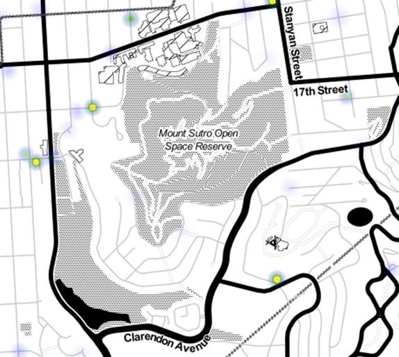
Separately, I’m not sure where the dispute with the city stands on who has responsibility for hazardous trees. The map below shows the issue: The purple line (I think) shows the UCSF boundary. (This map – made in Year 2000 -is based on an excerpt from the EDAW report done for UCSF. The colors just show in which direction bits of the mountain face…blue is north, red is west, yellow is south, and green is east.)

According to this map, the UCSF Open Space Reserve boundary is not exactly aligned to the roads. There’s a space between the road and the reserve. And that’s where some of the trees are that people are worried about. Of course, if the map is accurate, then one crucial area is fairly obviously UCSF’s: where Crestmont makes a sharp turn from North to East.
 As many neighbors will know, there’s an ongoing proposal to build 34 new units of housing at the end of Crestmont. The City is currently conducting an Environmental Impact Review (EIR), and Dr Sam Sobol (of the Crestmont- Mt Sutro Neighborhood Preservation Coalition) tells us the draft EIR is expected to be completed in September or October 2010. A large group of neighbors opposes it, and the Coalition’s website (click on the Stop sign to access it) details who to write to. That website also has more detailed information about the project and related issues. And photographs.
WHY THE OBJECTION
The project would extend Crestmont after a hairpin bend where the cul-de-sac ends now, and build along the lower edge of the resulting 20-foot road. This may impinge on land currently owned by a neighborhood association.

What’s the problem with the project?
This Google Map demonstrates some of the issues with the project. This is one of the steepest areas of the mountain. (The map already shows this road, complete with hairpin bend, even though it currently doesn’t exist – it’s a narrow mud trail. )
The hills are not only steep, they are not very stable. There’s a history of rock-slides, including the destruction of a home, fortunately unoccupied at the time.
The houses above where the planned project would go already rest on high stilts of steel or concrete. Residents fear that construction activities could weaken the hillside, putting the whole group of houses above it – and all the people in them – at risk during an earthquake.
(Click here for photographs of the site from the website of the Coalition.)

OTHER CONCERNS

The pink paint marking the drains, and the broken water main a few months ago, drew attention to all the stuff that’s happening below our streets. So the other day, we wandered around with our cameras pointing at all the circles and rectangles on the sidewalk. There were a lot of them: a wealth of services beneath our feet, representing civilization, urban comfort, and the conveniences of Forest Knolls. It’s strange to think we’re only a couple of generations away from fetching water from wells, using outhouses, and lighting our nights with candles and our streets with gas.
PG&E
It was an interesting mix of covers. This grating was like a piece of modern art, with the ladder reaching down to a reflective circle of water below. At first, it appeared to be a drain of some sort… but it’s got the words PG&E and “High Voltage.”

Another “High Voltage” cover was more prosaic, a simple concrete rectangle.

…

…
In fact, quite a few covers on the street were from PG&E. This manhole cover with a nice geometric design seems to be, though it’s difficult to know which cover does what. (If anyone knows, leave a comment! Or email us at fk94131@yahoo.com)
WATER DEPARTMENT
Another whole bunch were from the Water Department. (The sewer cover’s included here, though it’s actually labeled SFDPW.)


The little square with holes in it is most probably a drain cover.

But the handsomest cover on the street is a cast iron oval with the Golden Gate Bridge on it, labeled San Francisco Water Department Meter Box. Wonder when it was made? Some time in the 1950s, when Forest Knolls was built?

TELEPHONES AND TV AND ALL KINDS OF THINGS
And then there’s the Telephones. And the TV Cable. And the Survey Monument, which doesn’t represent a utility but instead helps put us on the map and define the lots on which our homes are built. And the Street Lights. And “Electrical” again, but it’s not clear what and why, though it may be connected with the Street Lights since the covers are together and next to a lamp post.


And then there was this odd-looking pair of covers labeled PT-T. Anyone know what they are?

.Edited to Add: PT-T probably stands for Pacific Telephones and Telegraphs… (see the comment to this post – Thanks, Laura).
Or why X marks the spot on this sewer-cover?

Edited to Add: Just saw this — the moss has picked out “Bell System” on this cover.