Season’s Greetings to everyone who’s reading this, and a Happy New Year in 2014!
This website and blog is just over four years and 300 posts old. It was partly meant to give Forest Knolls a web presence; partly to give it a public voice.
I’ve found that writing about this neighborhood really makes me appreciate it. Please feel free to join in – send photographs, make comments, write about things you’d like to share. Onward to Year Five!
Category: History

When Clarendon Avenue was Almshouse Road
The article below is republished with permission from Outsidelands (with some added emphasis). Click HERE for the original article. I want to thank Rex Bell for a wonderful step back in time.
———————————–
A WALK ALONG THE ALMSHOUSE ROAD:
A Historical Description of Today’s Clarendon Avenue
by Rex Bell
I’ve always been fascinated with San Francisco history. To indulge my interest, I sometimes try to imagine what areas of the City I’m so familiar with were like in the past. I recently got a little help when I discovered a detailed, descriptive article that appeared in the San Francisco Call on Sunday, November 8, 1896.
The author of the article is unknown and long forgotten, but he created with words a vivid image of what was then a truly rural part of San Francisco. He writes about his walk along a road, very close to the City, but well hidden and isolated. He clearly describes what he sees and hears along the way, orienting the reader to his starting point, the curves in the road, and the changes in grade.
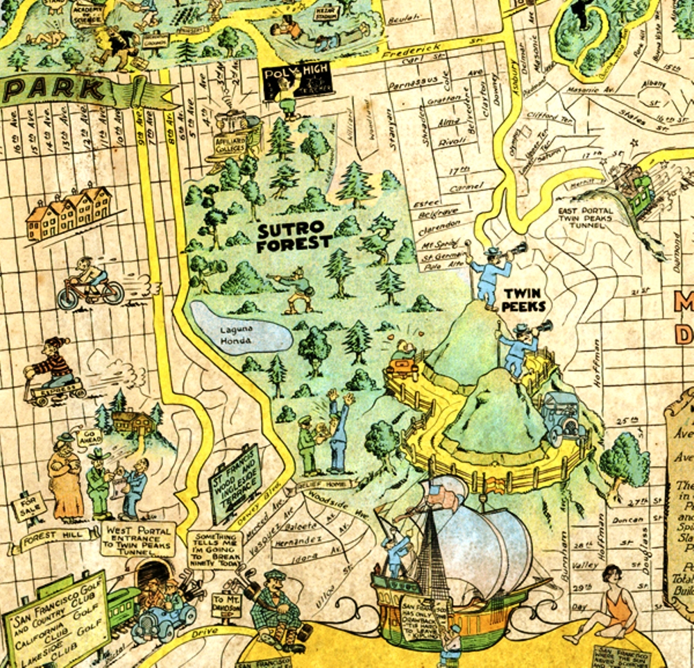
The author began his walk at the top of Stanyan Street, just above Cole Valley on the east side of Sutro Forest, on a clear Fall day in 1896. He described a place at that location where Stanyan transitioned into a dirt road that provided access to the beautiful rural path then known as the “Almshouse Road.” (So-named because it led to the Almshouse, which was an infirmary that housed San Francisco’s sick and poor of the day, located at the present site of Laguna Honda Hospital).

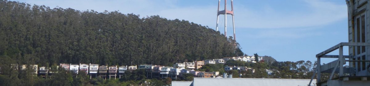
As I studied the article, I came to realize that much of what the author described is today known as Clarendon Avenue—the street that winds through a wooded portion of the City beginning at Twin Peaks Boulevard near Clayton Street. It heads up and over the hill along the eastern edge of Sutro Forest, descends down into a valley between the neighborhoods of Midtown Terrace and Forest Knolls, past the Laguna Honda Reservoir, and ends at Laguna Honda Boulevard.
On a Sunday afternoon in July 2011, I set out to retrace the steps that the author took on that day in the Fall of 1896. I began at his starting point (at what is now the intersection of Stanyan and Belgrave Streets), but I found the path blocked by houses. Slightly annoyed, but not dissuaded, I walked around— over Tank Hill and up Clarendon to where Stanyan once came come through. From this location, with a copy of the article in-hand, I began my walk back in time along the section of Clarendon that was once known as the “Almshouse Road.”


From the San Francisco Call, November 8, 1896:
“A GENUINE OLD-FASHIONED COUNTRY ROAD WITHIN THE LIMITS OF THE CITY OF SAN FRANCISCO”
“What other city in the world the size of San Francisco can boast of a country road within its limits, only a short distance away from the busy marts of trade? By this is not meant a street with a rural appearance, but a real road, without side walks or lamp-posts, that winds among tree-covered hills, past ranches and gardens and pretty homes, with vines and flowers in the yard, at the same time being shut out from all sight and sound of the busy metropolis. It is very likely that the city by the Golden Gate stands alone in this respect, as she does in many others. It is also likely that comparatively few of the residents of this City know of such a road’s existence, although most of them have undoubtedly been within a few hundred feet of one end of it.
“Nevertheless the road exists and is not at all hard to find. It is down on the map of San Francisco as “the Almshouse Road,” and the end nearest town starts at Stanyan street, several blocks south from the Haight-street entrance to the Park.”

The author began his walk where Stanyan Street joins Clarendon Ave. (red dot). He proceeded southwest through the valley between Blue Mountain (now Mt. Sutro) and the hill just to the east (right). (The latter hill is the present location of Sutro Tower. The buildings identified as the “Affiliated Colleges” are today’s UCSF Medical Center).
“At this point there is nothing unusual looking about the road, it having much the appearance of many of the newly laid out streets in the vicinity. It starts up a gradual incline and goes through a cut in the hill only about a block away. A little has been done in the way of improvement here. Wooden curbs have been put in and the center of the road is covered with crushed stone the same as is used in the park. But go up to the cut in the hill and look beyond. The entire aspect changes and every bit of suggestion of a city street disappears. The roadbed is simply laid on the surface of the ground and almost nothing done in the way of grading. On both sides there are hills and trees with vacant lots divided by fences.
“About two hundred feet from the end of the road it makes a curve and a descent at the same time, then a sudden ascent. Here there are a few small houses, and by turning back one can look over the park and even beyond and see the smoke of the big City mingling with the clear blue of the sky.

At about this location, the author turned back to look over the city. The Panhandle of Golden Gate Park is visible at the roofline of the house.
“But keep on and another descent will lead into a canyon and a few hundred feet up this and all sight of the big City is lost. When once within this big canyon it is hard to realize that only a few hundred feet to the northeast there is a big City throbbing and pulsating with life. There is no suggestion of it here, and as far as the general aspect of nature goes, one might as well be in the depths of the Sierras. Away to the south the road can be seen winding among the hills, every now and then disappearing behind a bluff only to reappear a short distance farther on.

Present day Clarendon Avenue. The spot is where the road “descends into a canyon”. Mt. Sutro (not visible in the photo) is to the right and the peak upon which Sutro Tower sits is to the left. It was just beyond this location where the author said, “one might as well be in the depths of the Sierras”.
“There is a breath of autumn in the air. The grass on the hill sides is sparse and brown, but the birds are singing and the murmur of the brook can be heard as it tumbles over the rocks. A gentle wind rustles the dead weeds and sends the dried leaves flying. Listen. Not the faintest sound of the big City comes in here. Surely this cannot be San Francisco. But it really is, and just over the hill to the right not much farther than a boy could throw a stone are well laid out streets, all the modern improvements that make up a metropolis.

The map from 1897 shows two creeks flowing into Laguna Honda Reservoir. (The grids of streets shown on the map were never laid out). The upper creek is likely the one the author heard “tumbling over rocks”.

– Photograph by Rex Bell


– Photograph by Rex Bell
“In the vicinity of the Almshouse the roadway is lined with pretty residences, and numerous ponds and reservoirs add to the country-like effect. Roosters are crowing, cows bellowing, dogs barking and hens cackling, mingled with the sound of the woodsman’s ax in the timber near by.
“The prettiest portion of the whole road is just beyond the Almshouse gate. It might properly be named the Eucalyptus road, for both sides of the driveway are lined with the most picturesque specimens of those artistic trees. The trees are just in their prime and make a most refreshing shade, that is pleasant to look at in cool weather and cooling when the sun is hot. This avenue is about 500 feet long, and in some places the branches of the trees meet overhead, forming a natural archway, the equal of any in the State. When the sun is low in the west and the trunks of the trees cast long shadows over the roadway, then is it indeed a beautiful sight. The spots of light dance as if endowed with life, and the whole interior of the archway is filled with a soft glow that mingles with the quivering sunshine.

“Beyond the Almshouse there is a clearing where the inmates of the institution are want to come and rest while seated in the sun on the logs of the newly felled trees. They add considerably to the picturesqueness of the scene, those poor old people, as they move about, many of them attired in the most outlandish garments of the brightest colors. But some how they seem to blend with nature, and even if the clothes they wear have been out of fashion over half a century, the wearers are proud of them; perhaps proud of the length of time they have had them.”
“Half a mile from the Almshouse gate the road is of the most countryfied description. There are barns and stables on both sides, and back on the hills dozens of vegetable gardens. At present these gardens are looking their best. Great rows of all sorts of good things are in the most perfect condition of greenness, and walking among them are gardeners singing at their work.
“Every foot of the Almshouse road is a pleasure to walk over to any one who enjoys nature. Add to this the fact that it is within the limits of one of the largest cities in the world, and the trip over it becomes a most unique experience.”
“A peculiar feature of the Almshouse road is that it can be followed for about two miles and suggest nothing but the country, but after that distance it makes a curve toward the City, and in a mile more comes back to the streets of San Francisco not many blocks from where it started.” (End of article.)

Around the bend and over the treeless portion of the hill (left) is the area not far from where the author began his walk.
The rural countryside has long since vanished, and the charming country road described by the author is now a four-lane boulevard. Most of the area has given way to residential housing. The Almshouse was long ago replaced by the Laguna Honda Hospital complex and Sutro Tower dominates the skyline for miles around.
But it would be wrong to say that absolutely nothing remains of the place described in the article. The rural roots of this part of the City still linger. Eucalyptus-covered Mount Sutro is still a forested wilderness and much of the landscape around Laguna Honda Reservoir remains undeveloped. Even within the quiet residential neighborhoods of Midtown Terrace and Forest Knolls, bisected by Clarendon Avenue, it still holds true that “…it is hard to realize that only a few hundred feet to the northeast there is a big City throbbing and pulsating with life. There is no suggestion of it here…“
Historic Forest Knolls Pictures from Earl & Connie Martin, Midtown Terrace Original Residents
Edited to Add (July 2012): I was sorry to hear that Earl Martin passed away last month, soon after this interview. I am honored that I had a chance to meet him.
Following the warm response to the 1961 picture of Forest Knolls I posted in Forest Knolls, Then and Now, I called Earl Martin to ask if I could post some more of his pictures here, rather than just linking them. He did better than just give permission: He kindly invited me over for a chat to the Midtown Terrace home he and his wife Connie have shared since 1957. Earl is 91, and Connie is 95, a gracious and engaging couple who were fascinating to talk to. They’re among the original residents who bought in while the homes were still being built.

“We come from manual labor,” Earl said. He was a carpenter when he bought the house, and Connie was an occupational therapist working at a hospital. For mortgage purposes, though, Connie’s income wasn’t considered part of the household income. “Because I had a Union job,” Earl told me, “We could buy this house, and Connie could stay home with the children.” (Those daughters, of course, are all grown up: One is a doctor of optometry, the other a nurse specializing in neo-natal ICU care.)
Connie didn’t stay home very long. First she started teaching at a Sunday School, then preschool two mornings a week, then eventually she became a preschool teacher “until I got too old.”
Earl was an armorer in the USAAF during WWII, stationed in the UK with the “Bluenosed Bastards of Bodney.” (Click HERE for a 3-minute video featuring this airforce group.) Later, he was a carpenter until the 1970s, when a company take-over pushed him into retirement. After that, he worked with machinery, both research and development, and sales and repair. “He’s naturally a Mr Fix-It,” Connie said.
After he finally retired, his father-in-law interested him in the stock market. “I made more investing than I ever did working,” he said.
When they occupied their home, Forest Knolls was a barren building site. “They had heavy machinery out there, building the terraces. Then they planted rye-grass to stabilize it.”

Here are some more of Earl Martin’s photographs. I asked him about permissions: Anyone may reproduce the pictures, but with attribution to him.

In this picture, a few houses have been built…

TRANSFORMATION
I found another cool 20-second snippet of video: It’s an aerial view that shows the transformation from 1938 – when the forest was only about 40-50 years old, but much more extensive – to the neighborhoods there now in 2012.
Click HERE to watch that.
Thanks to the realty website JacksonFuller.com who made it.
MORE INTERESTING PICTURES
And I’ll end with a few more pictures from Earl Martin: Of the newly-built Clarendon School –

and the old golf driving range…

… and one with a bit of the old Sutro Tower – much slimmer than its successor.

Here’s the view across to Mount Davidson, with its forest on the west and the bare East side where Leyland Stanford thought he’d develop housing.

Forest Knolls, Then and Now
A few residents of Forest Knolls may still remember what it looked like back in 1961 after the hillside was scraped bare and graded and covered with homes, some still under construction. When I happened upon this picture (taken by Earl Martin) on the Western Neighborhoods Project website, I immediately asked them for permission to reproduce it here. Woody La Bounty was kind enough to agree. It was taken at the dedication of the Midtown Terrace Playground, around 1961.
[Edited to Add: For more historic pictures of Forest Knolls and Midtown Terrace, click HERE.]

Here’s what it looks like today. Time and Nature and the green thumbs of residents over fifty years have transformed it from a building site to a green hill. This really looks like Forest Knolls.

Here it is again with some labels… (if you want to send in more, I can edit them in).
")
And here’s what the building site looked like, only three years earlier. Forest Knolls would be the bit labeled DEVELOPMENT.

Coffee and the 1%
I was out at Ocean Beach, recently, with one of our neighbors. It was a gray day, but fresh, and we walked down from the Beach Chalet to the Sutro Dunes “Natural” Area, and back.

She looked out at the beach. “The last time I was here,” she said, “we were making a big sign saying TAX THE 1%. It was amazing.” She waved in the direction of the sea. “They took pictures from the air. There were hundreds of us.”

Surprisingly, I hadn’t heard about the event, so she sent me a couple of the pictures. “I’m in the T of ‘the’,” she noted. The pictures are copyright, so I’m not publishing them here, but here’s a link. They’re pretty awesome. [ETA: They kindly gave permission, so here’s one picture. But do go to the link for more!)
There’s even a video on Youtube. They estimate that over a thousand people showed up. Looks about right from the pictures.
A GIFT SHOP AT BEACH CHALET, WITH COFFEE
At the Beach Chalet, we discovered something new: a gift shop that has coffee. And snacks like cookies and crackers and chips. It’s nice to have something handy to the beach. This is at ground level, perfect to drop in on after looking at the murals and the amazing carved balustrade of the staircase up to the restaurant.

Unfortunately, it’s not noticeable at all from outside or even as you enter. It’s only because we were wandering around looking at the exhibits in this little museum that we spotted it.

“It would have been great to have this around that day,” she said. “After the Tax-the-1% event, we went looking for coffee. We had to walk quite a ways to find it.”
Landmark Tree Tour
Last Saturday, SF’s Department of the Environment had a 3-hour bus tour of Landmark Trees and I went.
It wasn’t what I expected. I thought we’d see maybe the city’s most spectacular trees, on a cold foggy day. What we got was a bus ride through parts of the city I don’t usually see, a visit to a few trees, some fascinating local history, and the Quesada Street community garden. And really nice weather.

 We started with six old eucalyptus trees planted by Mary Ellen (“Don’t call me Mammy”) Pleasant, an amazing character who was active in the underground railroad. A little research indicates the trees are probably around 120-125 years old, about as old as Sutro Forest. They were gnarled and large – much wider and more branched than our Sutro trees, though not as tall. I think this is all about light: forest trees have to grow tall quickly to get sunlight before nearby trees block it; street trees in a sunny area need to grow bushy to take advantage of the available light, and develop thick trunks to support their heavily-branched structures.
The Canary Island Palms in the center of Dolores, about 175 of them, are landmark trees. Among them are four small endangered Guadalupe palm trees.
We saw a Moreton Bay Fig planted by Bancroft (of Bancroft Library fame); it has lost half its size owing to storms. It dropped a huge branch 2 weeks ago, making us wonder if it’s nearing the end of its life. [Edited to Add on Sept 16, 2010: Apparently it just dropped another branch, on top of a car. This site “Burrito Justice” has pictures.]
Then we saw an ancient Brazilian Pepper Tree, growing on a traffic island. It had also lost branches after storms.
 The tour ended at Quesada and 3rd street in Bayview Hunter’s Point, where the community saved a line of 13 Canary Island Palms in the median, planted around 1932. The city apparently wanted to fell them in the 1970s, because they needed too much maintenance. A few years later, neighbors started Quesada Gardens along the length of the median, and then added a mural at a cul-de-sac at the street’s end.

It was really inspiring, especially since one of the leaders explained that the median had been a trash dump before, and the cul-de-sac a place where people stripped down stolen cars. Overhead, squawking parrots flew in to feast on the palm fruit. It was sunny and pretty, and despite being in problem neighborhood, quite a few people on the tour thought they’d like to live there.
NATIVE TREES?
Mei Ling Hui, the cheery Urban Forests Coordinator who led the tour, remarked that most San Fran street trees were not native, and were similar species to street trees in Melbourne, Australia. She commented that eucalyptus were planted (1) because people liked eucalyptus and palm trees back then, and (2) developers planted them to drain marshes and furnish lumber for building, but it turned out eucalyptus makes crappy timber. She specifically mentioned Sutro Forest.
We pointed out that Sutro is on record as saying they were for the enjoyment of people who walked among them; it was only after his death that his heirs tried to start a lumber operation.
“…people… will wander through the majestic groves rising from the trees we are now planting, reverencing the memory of those whose foresight clothed the earth with emerald robes and made nature beautiful to look upon.”
She kindly made the correction.
She said non-native trees were planted because they did really well as street trees, and provided the benefits of urban forest trees, unlike trees from nearer here that required much more care and herbicides. Two authorities in the city plant trees: the Department of Public Works, and the non-profit Friends of the Urban Forest.
On the tour, I saw a lot of newly planted trees. Most were doing well, though a few were leaning over despite the cage of wooden posts intended to hold them upright. It was encouraging.
SAN FRANCISCO’S LANDMARK TREES
Total trees visited: 6 eucalyptus; many Canary Island Palms; 4 Guadalupe palms; a fig and a pepper tree. I’d expected to learn more about trees; instead I learned about local history, community gardens, and the Landmark tree program.
The Landmarking process is lengthy, and complicated, with an uncertain payoff. The result is that many truly spectacular trees are not landmarked. Some trees are landmarked because of a historical connection rather than because the tree itself is extraordinary. Some of the Presidio eucs are larger and more impressive than the ones we saw. Many of the Sutro Forest eucs are taller. I’ve seen some glorious araucarias in the western part of the city. Even the city’s Christmas tree (in front of McLaren Lodge) isn’t landmarked because Rec&Park doesn’t want to.
Here’s the current list of landmark trees, updated March 2009:
- California buckeye (Aesculus californica) at 730 28th Avenue
- Coast live oak (Quercus agrifolia) at 20-28 Rosemont Place
- Coast live oak (Quercus agrifolia) at 4124 23rd Street
- New Zealand Christmas Tree (Metrosiderous excelsus) at 1221 Stanyan Street
- Six Blue Gum (Eucalyptus globulus) adjacent to 1801 Bush Street
- All Canary Island Date Palms (Phoenix canariensis) in the center island on Dolores Street
- Brazilian pepper (Schinus terebinthifolius) at Third St. and Yosemite Street in the median triangle
- Flaxleaf paperbark (Melaleuca linariifolia)at 1701 Franklin Street
- Sweet Bay (Laurus nobilis) at 555 Battery Street
- Thirteen Canary Island Date Palms (Phoenix canariensis) located throughout the Quesada Street median West of Third St. to the dead end.
- Two Cliff Date Palms (Phoenix rupicola) in the Dolores Street median, one across from 730 Dolores Street and the second across from 1546 Dolores Street
- The grove of Guadalupe Palm (Brahea edulis) in the Dolores St. median, across from 1608-1650 Dolores Street.
- Moreton Bay Fig (Ficus macrophylla) at 3555 Cesar Chavez Street
- Two Flowering Ash (Fraxinus ornus) at the Bernal Height Library at 500 Cortland Street
- Blue Elderberry (Sambucus mexicana) in the Bernal Height Natural Area near the intersection of Folsom and Bernal Height Boulevard
- Manzanita (Arctostaphylos hispidule) 115 Parker Avenue
- Monterey Cypress (Cupressus macrocarpa) 2626 Vallejo Street
- California Buckeye tree (Aesculus Californica) located behind 757 Pennsylvania Street.
(Three others have been nominated: A Norfolk Island Pine and two Canary Island Date palms at 2040 Sutter Street, and a Redwood Tree at 46 Stillings Ave.)
But I didn’t get to see the city’s most spectacular trees. I might start blogging about those. There are certainly some really wonderful trees in San Francisco. I’ll be looking out for them. The only problem is how to photograph really huge trees. Meanwhile, ‘BurritoJustice’ carried a great tree post on their blog. With photographs.
History of Forest Knolls
Forest Knolls was built in the late 1950s and early 1960s. Some of the residents are the first owners of the homes that were built then. According the website of realtors Ahlheim and Kearney: “The detached homes and townhomes, many with similar floor plans, are well constructed and spacious. Winding streets, hilly terrain and ever changing weather add to Forest Knolls’ character and privacy. The original homes were built between 1959 and 1963. Crestmont Drive’s two unit buildings were built between 1962 and 1979. Galewood Circle’s townhomes were constructed in 1978-79. Newer homes on Warren and Oak Park Drives were built in the 80’s and early 90’s.”
The area where Forest Knolls was built was part of an 1100-acre forest planted by former mayor Adolph Sutro, one of San Francisco’s most colorful characters. Sutro Forest and the forest on Mt Davidson are among the last remnants of these woods. This map, from 1927, shows Sutro Forest before. Trees were cleared to build first Midtown Terrace, then Forest Knolls.
Before that, it was all part of Rancho San Miguel, a ranch with 2,000 cattle and 200 horses. Before Sutro bought the land, it was owned by Jose Jesus Noe (whose name is memorialized in Noe Valley).
For a historic picture of Forest Knolls, and a link to more pictures, go HERE.


CLICK HERE for a lovely description of a walk down rural Clarendon Avenue in 1896.
