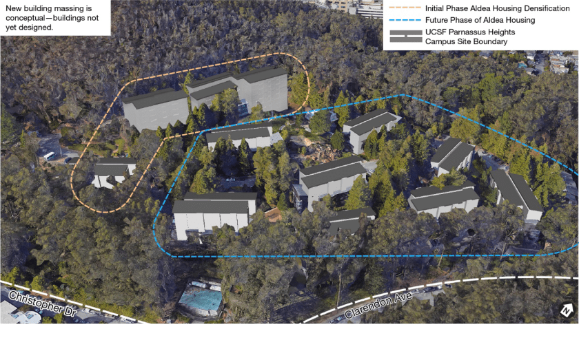
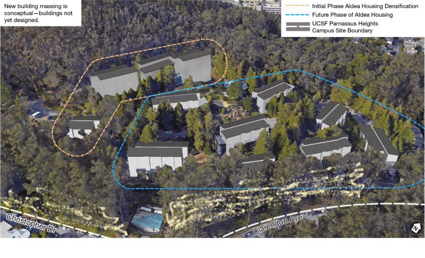
UCSF has revealed its plans for Aldea Housing. Back in 2014 when we reported that UCSF was removing Aldea student housing from the “space ceiling” that limited its expansion in the Parnassus area, we weren’t told what was planned. Now it’s been described in the 2020 DEIR (See the whole document here: UCSF-CPHP-Draft-EIR (1) ) Sept 11, 2020 is the last day for comments.
The plan is to demolish the existing low-rise wood-shingled buildings, and replace them with tall ones. The first phase will be three 8-storey and one 5-storey building. Here’s their impression from the DEIR document.
One of our concerns is that they’ll remove even more trees to accommodate the new buildings and the construction space to build them. We can probably expect most of the forest lying between Forest Knolls and the Aldea Housing to be thinned to the point that it is merely a few trees standing around instead of something resembling a wood.
I love that I can walk late at night in Forest Knolls. I’ve always enjoyed these magical (though infrequent walks). Now, with social distancing, they’re better than ever; there’s hardly anyone around.
Last week, I was out a couple of times. The first night was as still and quiet as if someone had turned off the world’s sound. On my way home I saw a dark shape on the sidewalk ahead. At first, it was so still that I thought it was a small abandoned suitcase or something. But as I came closer, it moved, and the light from the street-lamp showed me a raccoon. It looked at me and dived into the roadside shrubs. I went out to the middle of the road to give it enough room. Though I was pleased to see it. With all the precautions people (including us) take with their trashcans, I thought raccoons had abandoned our neighborhood for lack of food.
Another night, the quiet was broken by one of my favorite sounds: a Great Horned Owl up in Sutro Forest. It sounded like a lone owl, and stopped after a few hoots. Later in the year, perhaps I’ll hear the duets of a pair talking to each other.
And the same night, the best sighting of all: a coyote, out on Oak Park Drive near the staircase called Glenhaven Lane. When it saw me, it retreated up the staircase, and then onto the hillside so it could escape into the bushes if I pursued it. I didn’t, of course. I gave it a wide berth, and took a few blurry pictures with my cellphone.
This article is taken (with permission) from the SaveSutro.com website. It says UCSF’s Plan for Mount Sutro – which could start as early as this winter – could directly increase the risk for our neighbors on Christopher and Crestmont.
I started thinking about it. It’s a pretty insidious. The cutting of trees, and widening of the road to use heavy machinery and trucks up above our neighborhood could have very long-lasting effects – for five to ten years after the project, according to the research. Nothing might happen immediately – and then along comes a really wet stormy winter and whoosh!
Is this something real estate agents will have to disclose? I don’t know. And if something does happen – what’s the insurance situation? (I’m not even going to think of the risk to families living there.)
Anyway, this article is to let our Crestmont and Christopher neighbors know about these concerns. There’s more about the UCSF 2017 Plan on SaveSutro.com
Recently, we wrote that the Sutro Forest 2017 Plan Imposes a Landslide Risk. A University of Washington study shows that mudslides are most like 5-10 years after trees have been cut down on slopes. The picture below shows the South Ridge, which will be directly affected.
But it’s not just the tree-cutting. UCSF is widening two major trails into roads fit for heavy equipment, and adding nine quarter-acre “staging areas” for machines and felled trees. Both the roads are above Forest Knolls. (The heavy yellow lines in the map below are the new roads. The red squares are the locations of the staging areas, each of which will be a quarter acre.)
The picture at the top of this article gives some indication of how steep the hillside is. And the roads above Forest Knolls are atop a slope *known* to be unstable. Look at this landslide hazard map:
The double black arrows show landslide direction. The wiggly black arrows show soil creep direction. All those dark green areas? Potentially unstable. All the gold areas? Also potentially unstable.
Though the Draft Environmental Impact Report claims it’s making safety its first priority – it doesn’t look like it. In attempting to mitigate one (overstated) concern (dead trees falling), they’re worsening the risk of landslides.
This article is reprinted from SaveSutro.com with permission. The landslide hazard described touches our neighborhood; Christopher Drive and Crestmont are both in Forest Knolls!
This is risk that may actually increase over the years as a result of actions being taken now, for two reasons.
First, tree roots take time to die and rot, but when they do, they weaken the living geotextile that stabilizes the hillside.
Second, trees take up water and help to regulate moisture deep in the ground. When large trees are cut down and stop doing this, small saplings and ground cover are not an effective substitute. So if the trees are cut in dry or normal years, nothing may happen for a while – and then a really wet year can trigger landslides that would not have happened if the trees had remained.
Landslide under blue tarp. South Ridge at top left.
We’re reading the Draft Environmental Impact Report (DEIR) for the 2017 Sutro Forest Plan, and got to the section on landslide risk. This has been one of our concerns, especially since the tragedy at Oso, Washington, where the felling of trees in previous years was a factor in destabilizing the slope. (We wrote about that HERE: Cut Trees, Add Landslide Risk) We know this area is subject to landslides – we had a blue tarp covering unstable areas in Forest Knolls for a year when cutting trees destabilized a slope, and another just above UCSF’s Aldea housing area.
SHOCKING LANDSLIDE INFORMATION
We were shocked at what we found in the DEIR: “Increased instability could cause a landslide that would impact Crestmont Drive, Christopher Drive, and Johnstone Drive. An existing landslide scarp is visible above Christopher Drive. Some homes along Christopher Drive could be placed at additional risk from localized landslides due to plan implementation. Phase I activities would result in a potentially significant impact…”
The map above is taken from the DEIR. All the dark green areas are potentially unstable. All the gold areas are potentially unstable. All the cream areas are potentially unstable. The little red blobs and stars are already unstable. The black arrows show the direction of potential landslides – right into our communities. Here’s the key to the map. The light yellow and light green areas are where they are cutting down trees in Phase I (five years, starting this fall – 2017):
Legend to Landslide Hazard Map Sutro Forest 2017
What’s the proposed “mitigation”? Avoiding work in the forest for 2 days when the soil is wet after rain. This completely ignores the fact that landslides are a MULTI-YEAR hazard after tree removal.
Here’s the proposed mitigation in their own words:
“After a significant storm event (defined as 0.5 inches of rain within a 48-hour or greater period), the following conditions shall be met prior to any vegetation management activities:
The maps detailing areas of historic slope instability or rock fall in the Final Geotechnical and Geological Evaluation Report for UCSF Mount Sutro shall be reviewed (Rutherford + Chekene 2013)
If ground-disturbing or vegetation removal activities are proposed within or adjacent to areas of historic slope instability or rock fall, the saturation of the soils shall be estimated in the field; if muddy water drips from a handful of soil, the soil is considered saturated (Brouwer, Goffeau and Heibloem 1985)
The areas of historic slope instability or rock fall shall be flagged if the moisture content of the soils is determined to be high (i.e., muddy) and ground-disturbing or vegetation removal activities shall be avoided for a minimum of 48-hours after a significant storm event to permit soil drying…”
In other words, we won’t chop down trees in the rain or when the soil is wet.
Other mitigations are palliative. They’re planning to build roads into the forest for trucks and heavy equipment, and those roads will follow the contour of the slope. The quarter-acre staging plazas – where they’ll remove trees so trucks can turn around and heavy equipment be parked – will be flattish, with a slight slope for drainage. None of this is as effective as not building these roads or bringing in heavy equipment in the first place.
WHY THE MITIGATION IS MEANINGLESS
The problem is, the effect of cutting down trees is a LONG TERM problem. The effect of tree removal takes years – not days, not months – to fix. In Oso, Washington, the slope gave way three years after the last tree-destruction. Here’s the story (from the article we published at the time). The tragedy was foreseen… but the regulators thought they had enough mitigations in place.
On March 22, 2014, a huge landslide destroyed the small Washington community of Oso. Rain was of course a factor, as was erosion at the base of the slope. But it’s probable that tree-cutting above the slide area was an important factor too. An article in the Seattle Times that quotes a report from Lee Benda, a University of Washington geologist. It said tree removal could increase soil water “on the order of 20 to 35 percent” — and that the impact could last 16-27 years, until new trees matured. Benda looked at past slides on the hill and found they occurred within five to 10 years of harvests [i.e. felling trees for timber].
There had been red flags before. The area was second growth forest, grown back from logging in the 1920s/30s. Over 300 acres were again logged in the late 1980s.
The first time regulators tried to stop logging on the hill was in 1988. But the owner of the timber successfully argued that measures could be taken to mitigate the risk. Eventually, the state only blocked it from logging some 48 acres, and the owners gave in on that.
In 2004, new owners applied to cut 15 acres; when the Department of Natural Resources (DNR) objected, they halved the area and re-located the cut. DNR gave approval, subject to no work during heavy rain and for a day afterward. The tree-cutting finished in August 2005.
In January 2006, there was a major landslide 600 feet from the cut zone. The state built a log wall to shore up the slope.
The owners continued logging. In 2009, they removed 20% of the trees. In 2011, they removed another 15%. In 2014, the hillside collapsed.
The regulators were aware of the risk; they thought they were mitigating it with their restrictions and reaching a compromise with the owners. But it wasn’t enough. Destabilizing the mountainside is a long-term thing; the effects can show up in months, but it’s more likely to take years.
THE LESSON FOR MOUNT SUTRO
Our mountains not only are potentially unstable, they actually have landslides. The picture at the end of this article shows one on Twin Peaks, where rocks tumble after nearly every heavy rainy season.
The roots of the trees are helping to hold the unstable soil in place and that as the roots rot, landslide risk will increase. It is going to be more unstable 2-3 years after the trees are removed than 2 days after it rains. The information that instability increases over time is a little counter-intuitive.
Moreover, removing the trees takes away their ability to suck water out of the soil. If the tree-cutting is done in dry years, it may take a wet winter to trigger landslides… which would not have happened if the trees had been regulating the water and functioning as a living geotextile.
Since UCSF are not going to use herbicides on the stumps to prevent them from resprouting, they say they will grind the stumps. That is an effective way to prevent resprouting, but it will greatly increase the instability of the soil because the heavy equipment digs down several feet into the stump to destroy the roots. That’s another reason why they should not destroy trees where slide risk has been identified.
Anyone seriously considering the map above can only hope that UCSF will draw a better conclusion than the Washington State loggers and regulators. The planned destruction of thousands of trees – many within the first five years – could cause landslides in surrounding communities not days or months later, but years after the event.
I attended UCSF’s quarterly meeting of its Community Advisory Group on 3rd Dec 2014. (I’m not on the CAG, I went as a member of the public.)
UCSF’s Long Range Development Plan (2015-2035) has been approved. (This presumably includes removing the Aldea Student Housing from the space ceiling. You can read more about that HERE.)
Right now, there are two ongoing projects on the Parnassus campus (that’s the Inner Sunset campus, on the other side of Mount Sutro from Forest Knolls). The first is demolition and landscaping of 374 Parnassus, where a small building is being knocked down and converted to open space. The larger one is work on the old building, UC Hall which was earlier to be knocked down but is now to be converted to offices and housing.
SUTRO FOREST
UCSF staff made two presentations about Sutro Forest recently. One was to the Urban Forestry Council. The Council has a listening series in which they invited a large number of stakeholders to talk about San Francisco’s urban forests. (SaveSutro also made a presentation to them about Sutro Forest.) They expect to issue a report possibly next spring.
The other was to the Parks, Recreation and Open Space Committee (PROSAC). Christine Gasparac, who was one of the presenters, said that PROSAC was particularly interested in recreational access to Mount Sutro.
There was some discussion around Sutro Forest. CAG member Dennis Antenore spoke of the management plan written 14 years ago that embodied Best Management Practices. I pointed out that it didn’t – it was designed to cut down most of the trees. What management is implemented depends on what you’re trying to achieve. If you wish to preserve the forest – which is a unique and beautiful jewel of San Francisco – then it requires less intervention, not more. If you’re trying to turn it over to native plants, then you would want to cut down trees. Craig Dawson (also a CAG member, Executive Director of the Sutro Stewards, who favors cutting down trees and using herbicides to stop them coming back) said that the opponents of the plan were stopping UCSF from acting to save the forest and it’s dying.
They’ve been talking about the forest “dying” for years. (Here’s an article from the year 2000 – in which Craig Dawson is quoted. It’s based on the erroneous assumption that eucalyptus has a 100-year life-span, which is not true. It lives 300-500 years.) But experts inforestry, eucalyptus, and ecology have walked through and seen a healthy, thriving forest. Some trees are in poor condition, but that’s natural. If they are actually hazardous, they should of course be removed. But if they’re not, they’re valuable to the forest’s ecology. To say that the forest is dying because some trees in it are in poor condition is like saying San Francisco is dying because it has some people who are old and ailing.
DIVERSITY
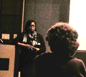
Dr Renee Navarro, UCSF’s Vice Chancellor for Diversity and Outreach, made an excellent presentation about UCSF’s progress in increasing the percentage of women and minorities among its students and employees. On the whole, they’ve done well in terms of employing women; UCSF staff are about 68% women, and even in the rarefied group of the 20 or so people who are in senior management, 40% are female.
For minorities, staff numbers superficially look quite good: around 58% non-white. There are two issues, though. First, most of this diversity is concentrated among the support staff. Only 36% of managers are minorities, and among the senior management, it’s 15%. Second, when it’s broken down, it shows the percentage of African Americans has actually declined between 2006 and 2014 – meaning growth in hiring hasn’t kept pace with UCSF’s expansion from 13 thousand employees in 2006 to 16.5 thousand in 2014. There’s been a marked increase in the percentage of Asian employees (from 33% to 37%), and some increase in the percentage of Hispanic employees, from 11% to 12.%)
It’s possible this reflects the changing demographics of San Francisco and the Bay Area, but UCSF is also taking measures to make attract and retain minority employees, and to create a multicultural and diverse organization.
She also spoke about community partnerships and early outreach to students in High School or even earlier, and opportunities UCSF is trying to create for its own employees to improve their skills and move to higher levels.
EBOLA
UCSF’s Intensive Care Unit at Mount Zion is their designated Ebola Isolation Unit should it become necessary. They are also encouraging medical workers who want to go fight the epidemic in West Africa to do so, preserving their jobs and seniority. There’s a quarantine procedure in place for when they return, depending on the level of exposure they have had. UCSF focuses on professional quarantine, but will co-ordinate with Department of Health in case community quarantine is appropriate.
OTHER ISSUES DISCUSSED
UCSF’s Mission Bay medical center is currently holding community tours and have had an excellent response. The hospital is scheduled to open February 1st, 2015, when a “stream of ambulances” will transport patients from Parnassus to Mission Bay.
UCSF has acquired two parcels of land – Blocks 33/ 34 in Mission Bay – and are beginning to plan what they’ll put there. Meanwhile, they are working with the City and the Warriors to figure out how to mitigate the traffic ad parking impact of the planned new stadium, which will be right next to the hospital’s Emergency Room.
They’re also proceeding with the plan to divest the Laurel Heights campus via a ground lease. They think the actual move from there will take about 4 years. It’s going to be replaced with housing and possibly some retail.
They continue with efforts to hire locally for construction projects. Part of the issue is they use Union contractors, who for skilled trades favor seniority over local residency. They also compete with other projects that seek to hire local workers in the construction trades.
UCSF has announced a meeting to talk about its plans for the Aldea San Miguel campus housing.
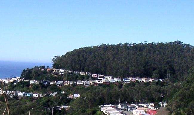
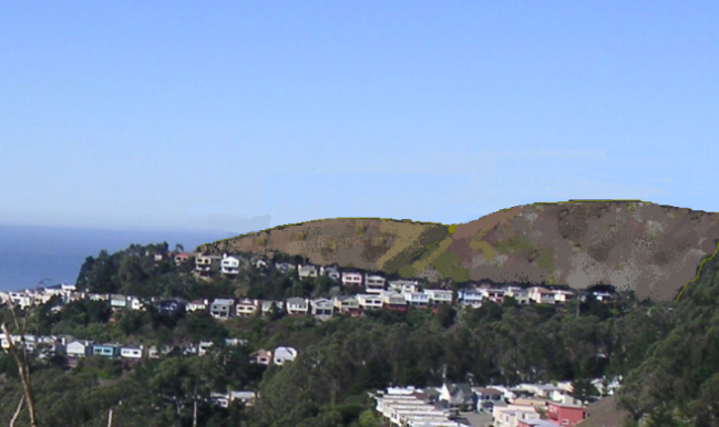
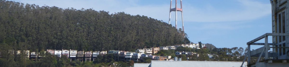
This is a cluster of wood-shingled buildings nestled at the foot of Sutro Forest, amid tall trees and landscaping. The house of the UCSF Chancellor is also in the same complex. It’s a charming place with almost a mountain-resort feel to it. It’s adjacent to our neighborhood, lying between Cole Valley and Forest Knolls and is approached from Clarendon Avenue and connects to Parnassus Avenue by Medical Center Way, a short winding route that resembles a country byway.
BACKGROUND
UCSF is in the midst of its Long Range Development Plan, which will be valid for 20 years. They expect to adopt it in November 2014.
In the 1970s, UCSF made an agreement not to expand in the Parnassus area. The Regents voted to impose ‘space ceiling’ that limited their space in the Parnassus areas to and also not to acquire any properties in the surrounding areas. (I attended a meeting in Feb 2014 and reported on that HERE.)
Here’s some background from one of my earlier posts.
“Back in 1976, UCSF had a strategy of stealth acquisition. It quietly acquired a bunch of houses (mainly in the 4th Avenue and 5th Avenue area in the Inner Sunset), used some eminent domain, and planned to knock them down and expand. It was trashing the neighborhood, and the neighbors revolted. The battle was bitterly fought, and went all the way up to Sacramento. When the smoke had cleared away, UCSF agreed to limits to growth in the neighborhood. The UC Regents passed a resolution. This had several important impacts on Forest Knolls.
It agreed to maintain the 61 acres of Sutro Forest as an Open Space. They weren’t going to build on it.
They imposed a limit – 3.55 million — on the total square footage in the Parnassus area. If they built something new, they would knock down something else.
They defined an expansion restriction area in which they would not acquire properties (they cannot accept gifts of properties in this area either. This restriction area – the map in the photo above – includes Forest Knolls (the line ends at Clarendon).
Recognizing that the influx of people (with the transport requirements and other pressures they bring) was also impacting neighborhoods, they included a goal of limiting the population to 13,400.”
WHAT’S UP NOW?
In fact, UCSF soon exceeded the space ceiling. They’ve also exceeded the people limit. (Details HERE.) But they have kept to points 1 and 3, maintaining Sutro Forest as open space, and not acquiring properties in the restriction area.
Student housing was explicitly excluded from the Space Ceiling, with the exception of Aldea Student Housing. Now, UCSF is considering excluding that, too.
What does that mean? I don’t know for sure. I’ve heard people say it could mean knocking down the old dorm buildings, and replacing them with something more modern. Probably not prettier, if the Hall they built a few years ago is any indication. Could it also be bigger? I don’t know. It depends on how they interpret their earlier undertakings – or how they choose to reinterpret them.
Will it impact the forest? It’s possible. In the last “fire safety” action, UCSF removed around 1,000 trees and all the understory on areas around the Aldea campus. This has made the forest in these areas much drier and less healthy, especially after drought conditions.
Will it impact Forest Knolls? Now that the forest between Forest Knolls and Aldea has been thinned to the point that Aldea is easily visible from Forest Knolls, whatever they do in Aldea will have more visual (and audible) impact on our neighborhood. What further impacts it may have I’m not sure.
Here’s the meeting announcement from UCSF. If you have concerns, it may be worth attending.
UCSF’s last Long Range Development Plan (LRDP), created in 1996, was designed to guide the university’s physical development through 2012. UCSF has embarked on its next LRDP, which has an expected planning horizon of 20 years. Community involvement is a key facet of this planning process.
This meeting will focus on the UCSF Aldea San Miguel housing complex. Information regarding past agreements with the community and current proposals within the draft LRDP will be discussed.
Date: Tuesday, August 12, 2014 Time: 6:30pm Location: Faculty Alumni House, 745 Parnassus Avenue @ 5th Avenue, San Francisco, CA
UCSF strives to ensure maximum public involvement in this important planning process. With an open and interactive process — identifying the best ideas and ensuring that all points of view are considered.
The UCSF Faculty Alumni House can be accessed by several MUNI Lines: #6, #43 and N-Judah. Parking is available in the Kirkham Avenue parking lot near the corner of Kirkham and 5th Avenue.
UCSF fully ascribes to the Americans with Disabilities Act. If at any time you feel you have a need for accommodation, please contact UCSF Community & Government Relations at 415-476-3206 or community@cgr.ucsf.edu with your suggested accommodation.
The San Francisco Forest Alliance and Save Sutro Forest are holding a meeting on 21 April 2013 to talk about the planned felling of trees on Mount Sutro — and on Mount Davidson. These actions would gut two important urban forests near our neighborhood and irretrievably alter the landscape.
Do you want to know:
How many thousand trees do they plan to cut down on Mount Sutro? On Mount Davidson?
Who’s “They”?
What about Pesticide use?
When will this happen?
For answers to these questions and more…
Come to the San Francisco Forest Alliance meeting.
WHERE: Miraloma Park Clubhouse, 350 O’Shaughnessy Blvd,
San Francisco, CA 94127
(It’s about 2 miles from Forest Knolls.)
WHEN: April 21st, 2013 (Sunday) – 4.30 p.m. to 6.30 p.m.
I guess by now, most people in Forest Knolls have some idea that big changes are planned for the forest behind our neighborhood. Essentially, UCSF plans to cut down over 90% of the trees on three-fourths of the forest, and remove 90% of the undergrowth. The only bit to be spared would be 15 acres or so of steep hillside on the western side, above Inner Sunset.
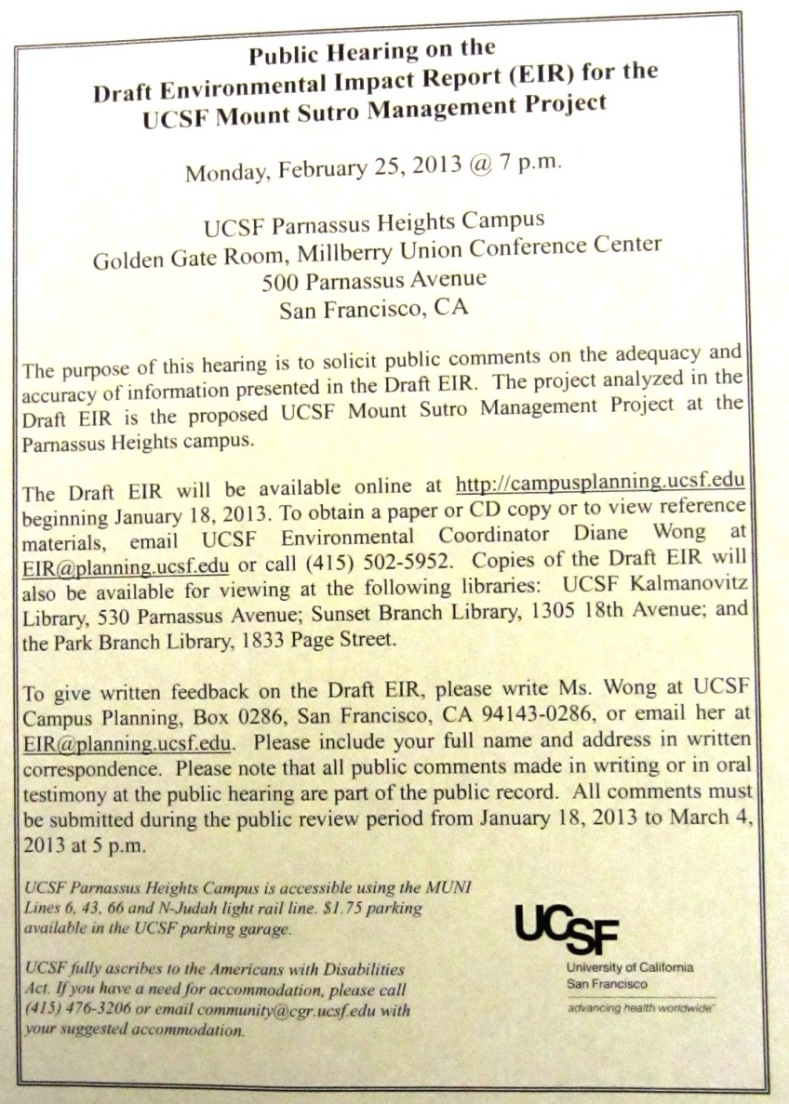
UCSF is having a hearing on Feb 25th at 7 p.m. (They sent around postcards about this.) It’s at the Milberry Union, 500 Parnassus, CA 94134. If you can attend, please do, and speak up. If there’s a big turnout, they may limit each speaker to 2-3 minutes, so have your points ready.
WHY WE’RE CONCERNED
We’re concerned that it would ruin the forest’s character, and Forest Knolls would face consequences like:
Changes in wind patterns (the tall, closely-spaced trees are an impressive windbreak);
Risk of landslides (the old forest has intertwined and intergrafted roots that function like a living geo-textile and hold up the mountain, while the exposed rock on Twin Peaks has a rock-slide every year or two);
Pesticide drift into our neighborhood, affecting us and our pets (right now, Sutro Forest may be the only pesticide-free wildland in the city; the Natural Areas Program, which controls most of it, uses pesticides regularly)
Increased noise (the vegetation – the leaves of the trees and the shrubs in the understory are like soft fabrics absorbing sound)
Changes in air quality (trees reduce pollution by trapping particle on their leaves until they’re washed down)
Environmental impact – (eucalyptus is the best tree species for sequestering carbon because it grows fast, large, is long-lived, and has dense wood; but felled and mulched trees release this carbon right back into the atmosphere).
The implementation would be in two phases; it would start with the “demonstration” plots, around 7.5 acres in Phase I. The largest of these, #1 in the map is a 3-acre strip directly above Forest Knolls. Most of the trees would be cut, and tarping or pesticides used to prevent resprouting. Later, UCSF would extend the same plan to the entire forest (except for the 15 acre piece mentioned).
WHAT ELSE YOU CAN DO:
1. Write to the Board of Regents, who will ultimately decide whether to approve this project. Ask them why they are undertaking this controversial, expensive, and ecologically destructive project, and gutting a San Francisco treasure to achieve a “parklike” environment. You can contact the Regents at their website HERE. (Their email address is: regentsoffice@ucop.edu )
2. Write a comment on the Draft Environmental Impact Report. The report is HERE. (It will take some time to load.) The person to write to is Diane Wong, and her email address is at: EIR@planning.ucsf.edu
The article below has been copied with some modifications from http://www.SaveSutro.com, which is a website set up to inform people about Mount Sutro Cloud Forest and to defend it.
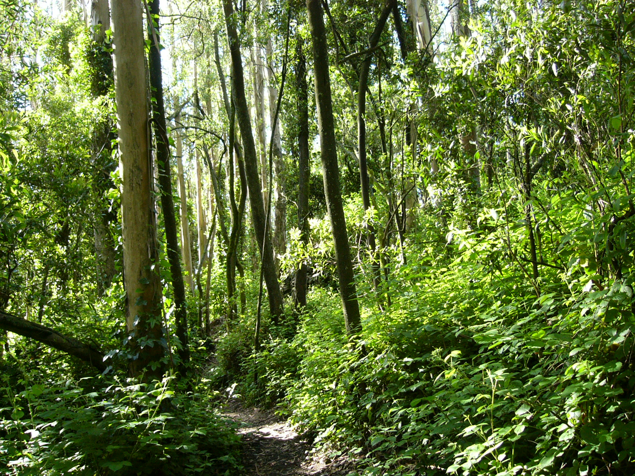
Mount Sutro Forest has approximately 45,000 trees in the 61 acres belonging to University of California, San Francisco (UCSF), and designated as an open space reserve. This dense forest, with an estimated 740 trees per acre, a sub-canopy of acacia, an understory of blackberry and nearly a hundred other plant species, is functionally a cloud forest. All summer long, it gets its moisture from the fog, and the dense greenery holds it in. Where it isn’t disturbed, it’s a lush beautiful forest, providing habitat for birds and animals, and a wonderful sense of seclusion from urban sounds and sights.
UCSF now has published a Draft Environmental Impact Report (DEIR) on a project to remove over 90% of the trees on three-quarters of the area. Only 15 acres – on the steep western edge of the forest – will remain as they are. Tree-felling could start as early as Fall 2013.
Comments were due on March 4th, but because of the length and complexity of the document, neighbors asked for, and got, an extension. Comments are now due before March 19, 2013.]
On most of the forest (44 acres), UCSF plans to cut down trees to achieve a spacing of 30 feet between trees – the width of a small road – and mow down nearly all the understory habitat. On another 2 acres, they will space the trees 60 feet apart. The stumps of the trees will be covered in black plastic, or else poisoned with Garlon to prevent re-sprouting. Eventually, this will kill the roots, which will start to decay. We’ll address some of these issues in more detail in later posts.
Right now, we want to talk about the number of trees that will be felled. A spacing of 30 feet between trees gives about 50-60 trees per acre. A spacing of 60 feet gives 12-15 trees per acre.
(The easiest way to think about it is that each tree occupies a 30 x 30 foot space, or 900 sq ft. An acre is 43,560 sq ft, so this would give 48.4 trees to an acre. The DEIR calculates it as 61 trees per acre, assuming each tree occupies a circle that’s 30 feet in diameter, 707 sq ft. But there’s no way to arrange circles without wasted spaces between them, so this doesn’t exactly work.)
So on 44 acres, they will retain maybe 50 trees per acre (or maybe fewer). On two more acres with a 60-ft spacing, they will retain 12-15 trees per acre. All the rest will be cut down. Even using the DEIR’s overly optimistic calculation, they will be felling some 31,000 trees. Our calculations are closer to 32,000. Either way, it’s a huge number.
That means that in the 46 acres where UCSF will be felling trees, they will remove more than 90% of the standing trees.
The DEIR says that they will start by cutting down trees that are dead or dying. Aside from their value as habitat (some birds like woodpeckers depend on them), there are not all that many of them in Sutro Forest, which despite everything that has been claimed to to opposite, is a thriving forest. Next in line will be trees with diameters under 12 inches, or roughly 3 feet around – as thick as an adult’s waist. Then they’ll start on the larger trees. Since it’s going to be 90% of the trees, we expect thousands of large trees to be removed.
IT GETS WORSE
However, this is not all. We expect further tree losses for four reasons:
Wind throw. Since these trees have grown up in a dense forest where they shelter each other, removing 90% of the trees exposes the remaining 10% to winds to which they’re not adapted. This can be expected to knock down a significant number of the trees not felled. Since the Plan only calls for monitoring the trees and felling any that seem vulnerable to wind-throw, it’s unlikely any vulnerable trees will be saved.
Physical damage. Damage done to the remaining trees in the process of removing the ones they intend to fell. With such large-scale felling, damage to the other trees is inevitable, from machinery, erosion, and falling timbers.
Pesticide damage. This forest has an intertwined, intergrafted root system. When pesticides are used to prevent resprouting on tree-stumps and cut shrubs and ivy, it is quite possible for it to enter the root system and damage remaining trees.
Loss of support. Compounding the effects of the wind-throw, the remaining trees will suffer from a lack of support as the root network dies with 90% of the trees being removed. This could destabilize them, and make them more likely to fail.
What remains will be a seriously weakened forest with a greater risk of failure and tree-loss, not the healthier forest that the DEIR claims. It is likely that the long-term impact of the Project will be the elimination of the forest altogether, and instead will be something like Tank Hill or Twin Peaks plus a few trees.
IMPLEMENTING THIS PLAN
The project is to be implemented in two phases. In the first phase, trees will be felled and the understory removed in four “demonstration areas” totaling 7.5 acres. They are shown on the map below in yellow, as areas #1-#4. [The 3-acre area #1 is right above Forest Knolls.] One of these, #4 “East Bowl”, is the two-acre area slated to have only 12-15 trees per acre.
One area (#5 on the map) is supposed to be a “hands off” area to demonstrate the untouched forest. However, a trail has already been punched through it in November 2011, even before the DEIR had been published.
During this phase, they would experiment with the 3 acres on the South Ridge, just above the Forest Knolls neighborhood. On 1 acre, they would use tarping to prevent regrowth of felled trees; on 1 acre, they would use pesticides, particularly Garlon; and 1 acre they would trim off sprouts by hand. They could also use pesticides on the understory “consistent with city standards” – presumably those of the Natural Areas Program (See article on NAP’s Pesticide Use.)
In the Second Phase, the plan would be extended to the remaining forest, with the proviso that not more than a quarter of the forest would be “thinned” at “any given time.”
Why it’s called “Forest” Knolls – and described as “Marin-like”Digitally-altered image – Forest Knolls without Sutro Forest. Maybe there’ll still be some trees left after this Plan is implemented.
I attended a Community Action Group (CAG) meeting of UCSF last evening, mainly about their Long Range Development Plan (LRDP), 2014-2035. (It was a follow-up to the previous meetings, one of which is reported HERE.) This meeting covered three broad areas: The Space Ceiling; Parnassus Avenue Streetscape and traffic; and UCSF Shuttle bus operations. But first, an announcement, important for anyone following the Mount Sutro forest battle:
The Sutro Forest Draft Environmental Impact Report (DEIR) will be published on Jan 18th, 2013. Then UCSF will take comments for 45 days; respond to the comments; and then they plan to certify the EIR. There’s a meeting on February 25th, at 7 p.m. during which people can give comments and feedback. (Clicking on the thumbnail picture here will take you to a larger – and hopefully readable version of the notice.)
SPACE CEILING
In that last article, I noted that UCSF had set itself a 3.55 mn square foot “space ceiling” in response to neighborhood anger at their expansion strategies in the 1970s. However, it shot past this space ceiling early on, and currently exceeds it by 8.2%. For many neighbors – especially those in the Inner Sunset – space ceiling compliance is one of the most important issues. They hoped the new LRDP would bring UCSF into compliance.
No such luck. It looks like it will actually go to as high as 9% over the limit when the existing Moffat Hospital is demolished and rebuilt, perhaps 10-12 years from now.
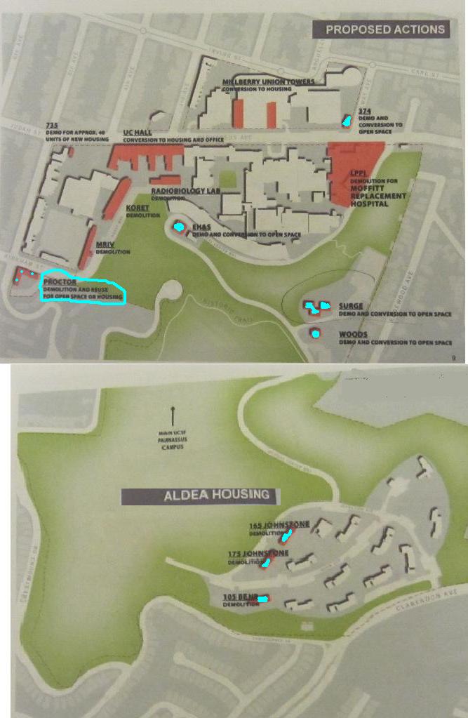
UC Hall, an old and historic building, was originally slated for removal. That would have reduced the excess over limit. But now they plan to convert it to a mix of housing and other uses. Since housing doesn’t come under the space ceiling, this helps – but it doesn’t actually reduce congestion and related concerns. Later, UCSF may convert UC Hall completely to student housing, thus taking it out of the calculation. They also plan a similar housing conversion for Milberry Union towers, which also will be gone from the numbers (though not from the campus).
Other minor reductions in the space ceiling will come from demolishing a bunch of small buildings, including several in the forest, and three blocks of student housing in Aldea campus. I’m finding this counter-intuitive. The main congestion impact is down in the Inner Sunset, so UCSF is demolishing buildings in the lightly-trafficked Sutro Forest, and adding housing along Parnassus?
Anyway, by a combination of housing conversions and minor demolitions, they expect to end 2035 at only 5% over the space ceiling, compared with 8.2% now. The map above shows the actual demolitions in turquoise; the pink buildings will either be demolished and rebuilt, or converted to housing. One building, Proctor, is undecided; it could be made Open Space, or converted to housing.
UCSF are also considering giving up their Laurel Heights space and co-locating those functions at Parnassus or Mission Bay (or both).
PEOPLE AND CROSSWALKS
The people numbers – which were originally supposed to be limited to 13,400 average daily population and then to 16,000 – is already at around 18,000. According to the forecast, it will rise to 18,500-18,900 in 2035. Members of the CAG were rather skeptical about this number.
In addition to construction and changes in use in the buildings along Parnassus, they plan to remodel the road itself to make it more pedestrian-friendly and give it a stronger sense of place. Better sidewalks and a huge cross-walk are in the plans. The tree plan involves removing some 60 trees that are hazardous or “poor quality” and planting around 70. They will also evaluate the redwood grove at Parnassus and 7th at some later date, if they haven’t removed it during their construction work first.
There was also a discussion of shuttle-bus operations, the upshot being that they may be better able to match demand (peak demand exceeds number of trips on some routes, but doesn’t match capacity on others) and supply.
The article below is republished with permission from Outsidelands (with some added emphasis). Click HERE for the original article. I want to thank Rex Bell for a wonderful step back in time.
———————————–
A WALK ALONG THE ALMSHOUSE ROAD:
A Historical Description of Today’s Clarendon Avenue
by Rex Bell
I’ve always been fascinated with San Francisco history. To indulge my interest, I sometimes try to imagine what areas of the City I’m so familiar with were like in the past. I recently got a little help when I discovered a detailed, descriptive article that appeared in the San Francisco Call on Sunday, November 8, 1896.
The author of the article is unknown and long forgotten, but he created with words a vivid image of what was then a truly rural part of San Francisco. He writes about his walk along a road, very close to the City, but well hidden and isolated. He clearly describes what he sees and hears along the way, orienting the reader to his starting point, the curves in the road, and the changes in grade.
The author began his walk at the top of Stanyan Street, just above Cole Valley on the east side of Sutro Forest, on a clear Fall day in 1896. He described a place at that location where Stanyan transitioned into a dirt road that provided access to the beautiful rural path then known as the “Almshouse Road.” (So-named because it led to the Almshouse, which was an infirmary that housed San Francisco’s sick and poor of the day, located at the present site of Laguna Honda Hospital).
As I studied the article, I came to realize that much of what the author described is today known as Clarendon Avenue—the street that winds through a wooded portion of the City beginning at Twin Peaks Boulevard near Clayton Street. It heads up and over the hill along the eastern edge of Sutro Forest, descends down into a valley between the neighborhoods of Midtown Terrace and Forest Knolls, past the Laguna Honda Reservoir, and ends at Laguna Honda Boulevard.
On a Sunday afternoon in July 2011, I set out to retrace the steps that the author took on that day in the Fall of 1896. I began at his starting point (at what is now the intersection of Stanyan and Belgrave Streets), but I found the path blocked by houses. Slightly annoyed, but not dissuaded, I walked around— over Tank Hill and up Clarendon to where Stanyan once came come through. From this location, with a copy of the article in-hand, I began my walk back in time along the section of Clarendon that was once known as the “Almshouse Road.”
This is the spot where my walk began on Clarendon Avenue. Stanyan Street no longer comes through. The sign points to several houses accessed by the isolated stairway.Top of Stanyan Street stairs at Clarendon Avenue, 2011 – Photograph by Rex Bell
From the San Francisco Call, November 8, 1896:
“A GENUINE OLD-FASHIONED COUNTRY ROAD WITHIN THE LIMITS OF THE CITY OF SAN FRANCISCO”
“What other city in the world the size of San Francisco can boast of a country road within its limits, only a short distance away from the busy marts of trade? By this is not meant a street with a rural appearance, but a real road, without side walks or lamp-posts, that winds among tree-covered hills, past ranches and gardens and pretty homes, with vines and flowers in the yard, at the same time being shut out from all sight and sound of the busy metropolis. It is very likely that the city by the Golden Gate stands alone in this respect, as she does in many others. It is also likely that comparatively few of the residents of this City know of such a road’s existence, although most of them have undoubtedly been within a few hundred feet of one end of it.
“Nevertheless the road exists and is not at all hard to find. It is down on the map of San Francisco as “the Almshouse Road,” and the end nearest town starts at Stanyan street, several blocks south from the Haight-street entrance to the Park.”
Route of the almshouse walk shown on 1915 map. Blue Mt. is today’s Mount Sutro. – Courtesy of Rex Bell The author began his walk where Stanyan Street joins Clarendon Ave. (red dot). He proceeded southwest through the valley between Blue Mountain (now Mt. Sutro) and the hill just to the east (right). (The latter hill is the present location of Sutro Tower. The buildings identified as the “Affiliated Colleges” are today’s UCSF Medical Center).
“At this point there is nothing unusual looking about the road, it having much the appearance of many of the newly laid out streets in the vicinity. It starts up a gradual incline and goes through a cut in the hill only about a block away. A little has been done in the way of improvement here. Wooden curbs have been put in and the center of the road is covered with crushed stone the same as is used in the park. But go up to the cut in the hill and look beyond. The entire aspect changes and every bit of suggestion of a city street disappears. The roadbed is simply laid on the surface of the ground and almost nothing done in the way of grading. On both sides there are hills and trees with vacant lots divided by fences.
“About two hundred feet from the end of the road it makes a curve and a descent at the same time, then a sudden ascent. Here there are a few small houses, and by turning back one can look over the park and even beyond and see the smoke of the big City mingling with the clear blue of the sky.
– Photograph by Rex Bell At about this location, the author turned back to look over the city. The Panhandle of Golden Gate Park is visible at the roofline of the house.
“But keep on and another descent will lead into a canyon and a few hundred feet up this and all sight of the big City is lost. When once within this big canyon it is hard to realize that only a few hundred feet to the northeast there is a big City throbbing and pulsating with life. There is no suggestion of it here, and as far as the general aspect of nature goes, one might as well be in the depths of the Sierras. Away to the south the road can be seen winding among the hills, every now and then disappearing behind a bluff only to reappear a short distance farther on.
– Photograph by Rex Bell Present day Clarendon Avenue. The spot is where the road “descends into a canyon”. Mt. Sutro (not visible in the photo) is to the right and the peak upon which Sutro Tower sits is to the left. It was just beyond this location where the author said, “one might as well be in the depths of the Sierras”.
“There is a breath of autumn in the air. The grass on the hill sides is sparse and brown, but the birds are singing and the murmur of the brook can be heard as it tumbles over the rocks. A gentle wind rustles the dead weeds and sends the dried leaves flying. Listen. Not the faintest sound of the big City comes in here. Surely this cannot be San Francisco. But it really is, and just over the hill to the right not much farther than a boy could throw a stone are well laid out streets, all the modern improvements that make up a metropolis.
– Courtesy of Rex Bell The map from 1897 shows two creeks flowing into Laguna Honda Reservoir. (The grids of streets shown on the map were never laid out). The upper creek is likely the one the author heard “tumbling over rocks”.
It [the creek] no longer flows on the surface but now runs just underground at the base of the lush gully located between Laguna Honda Hospital and Clarendon Avenue (below). – Photograph by Rex Bell“Although the road really goes up hill it does so so gradually as to be imperceptible. Every step takes one farther and farther into the depths of nature, and the canyon becomes almost wild for a short distance. There are big jagged rocks overhanging the way and seeming ready to fall at any moment. At this point the hills on both sides are so high the sea breeze is kept out and an absolute silence reigns.”
A section of the road that the author walked is visible in the lower portion of the photo. The cluster of buildings faintly visible at far left is the Almshouse. Laguna Honda Reservoir is barely visible in the distance near the center of the photo. The low spot in the foreground where the road forks is the present location of the Midtown Terrace playground and the covered Sutro Reservoir. This picture was taken from Twin Peaks in 1905; not a lot had changed since the article was written.The same location as the picture above, taken in July, 2011. Laguna Honda Hospital on the left has replaced the Almshouse. Sutro Reservoir is the large flat structure at middle-right. – Photograph by Rex Bell
“In the vicinity of the Almshouse the roadway is lined with pretty residences, and numerous ponds and reservoirs add to the country-like effect. Roosters are crowing, cows bellowing, dogs barking and hens cackling, mingled with the sound of the woodsman’s ax in the timber near by.
“The prettiest portion of the whole road is just beyond the Almshouse gate. It might properly be named the Eucalyptus road, for both sides of the driveway are lined with the most picturesque specimens of those artistic trees. The trees are just in their prime and make a most refreshing shade, that is pleasant to look at in cool weather and cooling when the sun is hot. This avenue is about 500 feet long, and in some places the branches of the trees meet overhead, forming a natural archway, the equal of any in the State. When the sun is low in the west and the trunks of the trees cast long shadows over the roadway, then is it indeed a beautiful sight. The spots of light dance as if endowed with life, and the whole interior of the archway is filled with a soft glow that mingles with the quivering sunshine.
Lithograph depiction of the old Almshouse on the present-day site of Laguna Honda Hospital. –
“Beyond the Almshouse there is a clearing where the inmates of the institution are want to come and rest while seated in the sun on the logs of the newly felled trees. They add considerably to the picturesqueness of the scene, those poor old people, as they move about, many of them attired in the most outlandish garments of the brightest colors. But some how they seem to blend with nature, and even if the clothes they wear have been out of fashion over half a century, the wearers are proud of them; perhaps proud of the length of time they have had them.”
“Half a mile from the Almshouse gate the road is of the most countryfied description. There are barns and stables on both sides, and back on the hills dozens of vegetable gardens. At present these gardens are looking their best. Great rows of all sorts of good things are in the most perfect condition of greenness, and walking among them are gardeners singing at their work.
“Every foot of the Almshouse road is a pleasure to walk over to any one who enjoys nature. Add to this the fact that it is within the limits of one of the largest cities in the world, and the trip over it becomes a most unique experience.”
“A peculiar feature of the Almshouse road is that it can be followed for about two miles and suggest nothing but the country, but after that distance it makes a curve toward the City, and in a mile more comes back to the streets of San Francisco not many blocks from where it started.” (End of article.)
The road leading to Seventh Avenue from Laguna Honda with Sutro Forest above, 1910s. The road back to the City, about half a mile north of the Almshouse (this is the location of present-day 7th Avenue). Around the bend and over the treeless portion of the hill (left) is the area not far from where the author began his walk.
The rural countryside has long since vanished, and the charming country road described by the author is now a four-lane boulevard. Most of the area has given way to residential housing. The Almshouse was long ago replaced by the Laguna Honda Hospital complex and Sutro Tower dominates the skyline for miles around.
But it would be wrong to say that absolutely nothing remains of the place described in the article. The rural roots of this part of the City still linger. Eucalyptus-covered Mount Sutro is still a forested wilderness and much of the landscape around Laguna Honda Reservoir remains undeveloped. Even within the quiet residential neighborhoods of Midtown Terrace and Forest Knolls, bisected by Clarendon Avenue, it still holds true that “…it is hard to realize that only a few hundred feet to the northeast there is a big City throbbing and pulsating with life. There is no suggestion of it here…“
It was late for a walk last night, and the fog had wrapped our neighborhood in its soft blanket. Yet the night called me, and out I went.
It was magical. The fog softened and dispersed the light of the streetlamps. As I walked up by the forest, I could hear the rain… except it was dry where I stopped on the sidewalk. In the forest, the trees made their own rain from the fog, and it pattered onto the leaves of the understory like a heavy shower. This is the Cloud Forest effect. Under the eaves of the forest, the cloud-rain was heavy enough to flow down the street and into the gutter. Inside the forest, the undergrowth and the duff absorbed it all. (If you walk in the forest — be prepared for mud on some of the interesting trails.)
It was late enough that I shouldn’t have expected anyone to be out there. But I’d have been wrong. In 30 minutes, I encountered 4 people, all walking dogs. As I said once in a post, the dogs of Forest Knolls make us all safer. Paws on the street mean eyes on the street.
As some of you already know, I received a letter from a major law firm on behalf of Sutro Stewards whose Executive Director is Craig Dawson. (It was actually for San Francisco Parks Trust and Sutro Stewards.) It said two things: First, that I had defamed Craig Dawson and the Sutro Stewards; second, that I had violated copyright on two maps. Most the of the allegations pertained to another website, www.sutroforest.com, which is a website fighting for Sutro Forest.
However, the copyright issue touches this website via a map I published in my post on hiking in the forest. I believe the map I used was based on one that was non-copyright. Nevertheless, I have taken down the map. For now, I’ve provided a link to a trail map; later I’ll add back a map for readers of the post to reference. [ETA: I’d also used it to explain what UCSF plans to do with the forest. That’s also been removed for now and will be replaced later.]
WHAT WAS THE ISSUE, ANYWAY?
The Letter said I had violated a Sutro Steward copyright.
This was confusing on several levels.
1. The map I used was distributed at a meeting called by Rec & Park. Rec & Park circulated it as Exhibit B of a memo for an agenda item before the Parks Commission, cropped exactly as described above. It carried no copyright information or attribution. [ETA: This memo can be obtained from Rec & Park under the Sunshine law. Anyone can get a copy.]
Did Rec & Park steal the map without the Sutro Stewards’ knowledge? No. The minutes show that both Craig Dawson and Ben Pease were at the hearing and were thus fully aware of how it was being used. In fact, Craig Dawson is mentioned in the memo under “People to Contact.” (Maybe one of them actually provided the map to Rec & Park?)
In my understanding, this has the effect of making it non-copyright: It is part of a memo prepared by a Rec & Park employee, whose (official) work cannot generally be copyright; and it wasn’t attributed to any other source. That’s why I felt free to use and make derivative maps as the Letter described.
2. How was it ever owned by Sutro Stewards? The copyright of even the original map is owned by Ben Pease and Pease Press. (That’s what the Letter says, I don’t know because the map I’ve been using has no copyright info.) While I believe Ben is a member of the Sutro Stewards, he is an independent entity. Did Ben Pease assign his copyright to Sutro Stewards? If so, shouldn’t the Letter mention it? If not, why isn’t it Ben Pease writing to me through his lawyer (or directly), instead of the Sutro Stewards through their lawyer?
3. So why did I take down the map? Well, I enjoy a discussion of copyright issues, but honestly, this is trivial. If it makes them happy, I’m okay with removing it. The map made the post easier to understand, and so I’ll look to replace it; but it wasn’t crucial to its value. The idea of that post was to share how to visit the forest, and I think it still does that.
And — I’d like to put in a plug for Pease Press Cartography. The Sutro Trail map (a PDF file) isn’t the only map he has on his site. If you’re a hiker, check out his trail map of the whole city. It’s the kind of amazing, a local business based on one person’s cartographic skills. Even the name is cool, and he has a really delightful logo… look out for it.
[I’d welcome comments here — just bear in mind they’re moderated and won’t show for a few hours or even a day. Or of course by e-mail at fk94131 at yahoo dot com.]
One of our neighbors, Lulu Carpenter, sent me a bunch of photographs she took on a walk around Forest Knolls. I was struck by two things. First, how much they resembled picture postcards. Any casual view seems to have a scenic quality to it. Second, how much the forest determines the character of our area — the look and feel and scent and sound — especially since, unlike Cole Valley or Forest Hill, we have hardly any street trees.
UCSF has sent out a notice that the newly re-opened Medical Center Way (i.e. the pretty Sutro Forest short-cut from Clarendon to Parnassus) will close for two days. From 8 a.m. to 5 p.m. Friday and Saturday, 26th and 27th November, the road will be blocked to traffic to allow heavy machinery through. They plan to re-open the road that Sunday morning. (In the map below, the green line indicates Medical Center Way.)
UCSF is removing 11 trees from the Western end of the new Regenerative Medicine Building (the “Stem Cell Research Building”). That’s the blue circle in the map above. The trees have been declared hazardous.
[Edited to Add Follow-up]
The trees have been removed; the road is open. Here are the Before and After pictures:
Medical Center Way is open again. This is the lovely mountain road that goes through Sutro Forest, connecting the UCSF Aldea student housing to Parnassus (and is the shortest route from Forest Knolls to Stanyan). I’ve heard it called the prettiest road in San Francisco, and people have told me they take that route just for its beauty. Certainly I’ve trundled down the half-mile stretch between Johnstone and the dog-leg above Parnassus at 15-20 mph, taking in the splendour of the trees and the scent of eucalyptus. It’s looking shorn now; a lot of the understory growth has been cut back, and some of the trees are gone. But even if not the lush wild place it was before, it’s still lovely.
A spaceship in the forest?
It had been closed for nearly a year, for the construction of UCSF’s stem cell research building (or rather, The Center for Integrative Medicine). That building looked amazing in the drawings, and fantastic from Golden Gate Park: like a spaceship that had landed in the forest. And someone else, gazing at the building said, “It looks like it’s been CGI’d into the forest.” (If anyone has a better picture, please send it! This really doesn’t do it justice. ETA: Thanks… this is a lot better.)
Close up, not so much. Snaking along the lower reaches of Medical Center Way, behind the hospital on Parnassus, it’s sheathed in what looks like aluminum siding. “Like a trailer abandoned by the roadside,” sniffed my companion. It does have a rather boxy, automotive appearance, like an RV or a railroad car. This is a pity, because the actual structure has a lot of interest.
That’s visible from the loading dock side, which isn’t technically a public access area. The box curves along the road, and it’s balanced on a network of struts that isolate it from its base in case of an earthquake. With the tall trees behind and beside it, it looks somewhat surreal.
[ETA 2: Here’s another article on the building, with a lot of architectural details. I notice they’ve used our spaceship metaphor. The sincerest form of flattery! And this article is from UCSF itself.]
We’ve been sent a report on a new cat that has shown up in the forest in the Belgrave/ Stanyan area. It’s probably someone’s pet. We don’t have photos, hence the public domain drawing on the right; but here is the description:
“It’s clearly some sort of purebred Siamese, maybe a lynx point? Big tawny body, very Siamese face and large ears. I was wondering if you’ve heard about any lost cats? This cat must have belonged to somebody. If you hear of anything, please let me know. I’ve just spotted it once, but the construction workers have spotted it a few times. The cat seemed quite fearful, sort of slinking along atop a fence, then down into the woods.”
(There’s construction work going on at Belgrave; a home-owner on the forest edge is doing a major re-model.)
If it’s your cat, contact us at fk94131 at yahoo.com and we’ll try to put you in touch with the people who’ve seen it.
One of the neat things about our neighborhood is that it’s so close to Tank Hill and to Twin Peaks, both excellent viewing platforms for anything happening on the Bay – flying exhibitions, firework displays, or fog flow.
On Saturday, armed with binoculars and pocket-camera, I went up to Tank Hill for the Blue Angels. The place was quite crowded, though some people, misled by the warm day, were driven off by the strong wind before the show ended. I’d worn a windcheater, so I was fine; it was the t-shirt crowd that were cold.
It was great. Not only could we see all the way over to the Golden Gate Bridge and the Bay, we could see the planes come by our own Sutro Forest.
On Sunday afternoon, I actually went into the forest, even though very little of the airshow is visible from there. But a couple of times, the planes come blasting past the forest, behind the eucalyptus. There’s something surreal about it – the contrast between the very sylvan forest and the power and thunder of the most artificial thing – a jet aircraft. I got a couple of poor-resolution photographs, but a spectacular experience.
In order to improve AT&T cellphone coverage in the shadow of Mt Sutro, UCSF is adding two temporary cellphone antennae: One at 400 Parnassus Avenue (which is down on their campus) and the other about halfway up Medical Center Way, quite near Edgewood Avenue. They’ll be on the roofs of existing buildings, and no trees will be felled on Medical Center Way to accomodate the antennae. It’s not overly visible (see the picture for a simulation, taken from UCSF’s Q&A pages). The temporary antennae will help AT&T coverage immediately.
A permanent installation is planned in about a year; that may be larger, and cover three providers. UCSF is looking at AT&T, T-Mobile, and Verizon.
Damon Lew, from UCSF’s Community Relations Office, sent out this message:
“To improve cellular phone service for doctors, nurses, patients, visitors, and staff of the UCSF Parnassus Campus, temporary cellular antennas will be installed on the Ambulatory Care Center at 400 Parnassus Ave. and on the Environmental Health & Safety facility at 50 Medical Center Way. Permanent equipment will eventually be installed to maintain good cellular telephone coverage and we will keep the community informed as the project proceeds. Installation of the temporary cellular antennas is scheduled to begin October 11…”
On the Landmark Tree Tour I wrote about recently, they were passing around an interesting book with a green cover: The Trees of San Francisco. “Mike Sullivan never met a tree he didn’t like…” said the inside flap, about the author. And he called eucalyptus “Australia’s gift to California” (though he takes a neutral position on the Sutro Forest issue). It was full of photographs and descriptions of San Francisco’s street trees.
I had to have this book.
Ready for a Tree Exploring Walk
It arrived today and it’s even better than I thought. The descriptions are lucid and easy to read. The photographs (by Jaime Pandolfo, a Brazilian resident of San Francisco) are beautiful; some are so artistic you can almost imagine them as posters. And it includes a whole bunch of walking tours, laid out by neighborhood and noting the special trees.
Unfortunately, some of those trees are now not what they were, as storms have taken their toll. A picture of the city’s Christmas Tree – a Monterey Cypress – in front of McLaren Lodge in Golden Gate Park shows the tree in its heyday; today, it’s sadly diminished as large branches have fallen off.
But many of the trees are even bigger. And with all the new trees being planted, we hope later editions of this book will still have thousands of trees to celebrate. Meanwhile, Mike Sullivan has a convenient website at sftrees.com that includes some updates to his book.
(Details: The Trees of San Francisco by Mike Sullivan, Pomegranate Communications, 2004)
It’s been a foggy summer, and here in the Fog Belt, it’s been like living inside a cloud.
It’s the perfect time, if you like mysterious ethereal forests, for a walk in our neighborhood Cloud Forest. On a foggy day, it may be the most beautiful place in all of San Francisco .
So for those who haven’t done it before… here’s my personal guide to the forest.
There are several ways to approach the forest from our neighborhood, but I’ll divide them into the Adventurous and the Easy. On foggy days, you could describe them as Wet and Dry. Generally, there’ll be few people on either set of routes (though maybe a few more on the Easy ones).
The two routes that lead directly from Forest Knolls are what I call adventurous, for two reasons.
First, access is very steep, especially for the first part of it. It involves scrambling up a trail. It’s not inaccessible by any means – I’ve been up there with neighbors in their sixties. But … it’s not a walk in the park. Also, it’s easier going up than coming down it, so you might plan a route that returns by a less steep path.
Second, on foggy days, it leads into the deepest Cloud Forest. This is actually my favorite part, but it’s Wet. The ground can get very slushy indeed, and I often return with much mud on my shoes and jeans. Sometimes, the narrowest trails can become boggy.
The first route starts with a few steps opposite 365 Crestmont. On the map, it’s the West Ridge Trail. It’s narrow and you may need to go carefully, moving back blackberry stems as you go. (And be aware there may be poison oak around.)
The second is the access to the South Ridge, opposite 101 Christopher, between the lamp-post and the chain-link fence (fenced radar site) hidden among the bushes. It may even be a little steeper.
There’s also another access point on Crestmont, about halfway between these two, but I think that’s maybe unofficial. It seemed to have more poison oak, too. And finally, I have sometimes scrambled up the Gash left by the SFPUC’s water-pipe replacement (on Christopher) but I don’t recommend it because it’s very steep. It brings you to the Aldea campus.
THE EASY ROUTES
The “dry” routes, which are still lovely but don’t feel as wild, start out in the Aldea Student Housing. If you want to drive up, you can sometimes find parking on Clarendon Avenue next to the campus. There’s no public parking on the campus itself.
Here again, there are two options.
1) If you go uphill on Johnstone and then along Behr, you will come to a chain blocking vehicle access. That’s the Nike Road, and it’s wide and paved. If you follow it to the top (this is a pretty short route) , you will find the Native Garden, officially the Rotary Meadow. It’s about 3 acres of shrubs, (which are green this time of the year) and grass (which is brown). It has wide gravel paths, and is surrounded by the forest. You can investigate some paths with an easy out if it becomes too steep or slushy.
2) The second option is the Fairy Gates trail, which starts on Johnstone, right in front of the Chancellor’s House. (That’s the very elegant house opposite the lower intersection of Johnstone and Behr. Do stop to notice the stand of redwoods right there…) This trail is pretty dry, not too steep, and quite broad except where it goes between two rocks (the “Fairy Gates”). It used to be more wooded in feeling, but some trees have been removed on either side and it’s now very open except at the beginning. It offers views of the forest in the ravine below, and has nasturtiums blooming along parts of it. It ends on the road through the forest, Medical Center Way. Though that is open to traffic, it has sidewalks. Also, not much traffic goes that way, especially not now when the bottom end is closed for construction. [ETA: It’s reopened. Watch out for cars, but there’s still not much traffic.]
If you feel like checking out the forest a bit more, the bottom part of the Historic Trail is also relatively dry, though if you follow it to the top it takes you back into the clouds. The Edgewood Trail will take you down into the Edgewood neighborhood. It’s steep but not very muddy. This area has some huge trees and interesting terrain.
3. [ETA June 2011: There is a new trail now from Stanyan (just above 17th) that climbs up to Medical Center Way. Of course, you can also take it in the opposite direction. Though it’s a climb, it’s quite broad and easy to hike. Its bottom end starts with a wooden staircase between two houses; the top end connects to Medical Center Way.]
OTHER TRAILS
These are many other trails, of course. Exploring the whole mountain probably wouldn’t take more than 3-4 hours. The rule of thumb is that in areas where the forest canopy is open and the undergrowth thinned, the trails tend to be dry (and sometimes slippery with dust and dry leaves). Where it’s closed, and the undergrowth remains, it’s usually damp or wet (and sometimes slippery with mud). Dress warm on foggy days, and expect it to be quite cool even on warmer ones. I always wear long sleeves, jeans, socks and walking shoes I can get muddy. (It also helps in case of poison oak… haven’t been hit by it yet, in all the time I’ve wandered around in there.) There’s a checklist here.
Despite all these warnings, this is a pretty accessible forest. To me, it’s completely worth it to be among those tall trees, their tops in the gray mist while inside the forest it’s fresh and green in the dimness. Birds don’t sing much in the fog, but there’ll be the odd tweet or rustle. Sounds get muffled. Usually, there are few people around. It’s the wild part of the woods. If it’s twilight, you might hear or see the Great Horned Owls. For those who enjoy a little walk on the wild side, one of the best features of Forest Knolls is the forest.
 +
+