Most of us, very fortunately, haven’t ever had to run for our lives ahead of a fire or flood or earthquake. But if it happens – it’s difficult to think straight. Someone posted this “Grab & Go” to Facebook and it looked so useful that I printed several copies.
This article is taken (with permission) from the SaveSutro.com website. It says UCSF’s Plan for Mount Sutro – which could start as early as this winter – could directly increase the risk for our neighbors on Christopher and Crestmont.
I started thinking about it. It’s a pretty insidious. The cutting of trees, and widening of the road to use heavy machinery and trucks up above our neighborhood could have very long-lasting effects – for five to ten years after the project, according to the research. Nothing might happen immediately – and then along comes a really wet stormy winter and whoosh!
Is this something real estate agents will have to disclose? I don’t know. And if something does happen – what’s the insurance situation? (I’m not even going to think of the risk to families living there.)
Anyway, this article is to let our Crestmont and Christopher neighbors know about these concerns. There’s more about the UCSF 2017 Plan on SaveSutro.com
Recently, we wrote that the Sutro Forest 2017 Plan Imposes a Landslide Risk. A University of Washington study shows that mudslides are most like 5-10 years after trees have been cut down on slopes. The picture below shows the South Ridge, which will be directly affected.
But it’s not just the tree-cutting. UCSF is widening two major trails into roads fit for heavy equipment, and adding nine quarter-acre “staging areas” for machines and felled trees. Both the roads are above Forest Knolls. (The heavy yellow lines in the map below are the new roads. The red squares are the locations of the staging areas, each of which will be a quarter acre.)
The picture at the top of this article gives some indication of how steep the hillside is. And the roads above Forest Knolls are atop a slope *known* to be unstable. Look at this landslide hazard map:
The double black arrows show landslide direction. The wiggly black arrows show soil creep direction. All those dark green areas? Potentially unstable. All the gold areas? Also potentially unstable.
Though the Draft Environmental Impact Report claims it’s making safety its first priority – it doesn’t look like it. In attempting to mitigate one (overstated) concern (dead trees falling), they’re worsening the risk of landslides.
Yesterday, I was horrified to receive this letter from some Forest Knolls neighbors. This is re-posted with permission. We stand with them against hatred.
[Edited to Add: If you want to email them in support, please use this email address: TamayoLee2017 at gmail.com ]
Dear Neighbors,
First Amendment Rights are being threatened here in Forest Knolls.
We are writing to you to seek your support for ensuring that residents of our neighborhood can express themselves without threats or fear of harm. Since late 2014 or early 2015 we have had a Black Lives Matter poster in our living room window at 11 Christopher Drive. No incidents have occurred because of the sign.
However, in mid-July 2017 we received an anonymous note in the mail addressed to “RESIDENT, 11 CHRISTOPHER DRIVE, SAN FRANCISCO, CA 94131” with the message “BLUE LIVES MATTER! Get rid of your sign, or WE will!”. We did not take any action at that time.
However, another note was mailed addressed to ‘BLM, 11 CHRISTOPHER DRIVE, SAN FRANCISCO, CA 94131″ postmarked August 14, 2017 – the Monday after the tragedies in Charlottesville, VA — which stated “It’s time to replace your BLM sign. How about CHINK LIVES MATTER”. (“Chink” is an anti-Chinese slur originating from the turn of the 20th century.) We reported these notes to the FBI and to the SFPD Park Station on August 17. We surmise that the notes were from someone who passes by our house on a regular basis and is aware that we are of Asian descent.
We placed the BLM sign in response to a national concern that African-Americans were not only victims of deadly violence but also suffered ongoing discrimination and disparities in health, education, job opportunities, etc. In June 2015, nine African-American members of an African-American Methodist church in Charleston, South Carolina were murdered in cold blood by an avowed racist. And as the recent events in Charlottesville point out, our concerns of a rising intolerance to people of color and immigrants are not unwarranted. We are sharing this experience with you as our neighbors so that we can ensure that all our lives are safe and that we can all continue to exercise our rights to post the BLM sign or display any other political statement of our choosing. (The sign was taken down in August as a safety precaution for houseguests, but it will be back up very soon.) We also want to make sure that our neighbors and other San Franciscans are not silenced.
We have lived at our house since January 1993, nearly twenty-five years. We have enjoyed our home, tending our colorful flower garden, creating art on our side fence, walking in the newly expanded trails of UC’s forest and meeting others at the reservoirs/ Tank Hill with our dog as well as at Forest Knolls back bench social and summer street parties. We are natives of San Francisco and our children have attended SFUSD from kindergarten to senior year.
Debbie is a Senior Vice President for Futures Without Violence, a national non-profit addressing domestic and sexual violence and child trauma, where she has worked for over thirty-five years. She and her mother have tended our front garden over the last fifteen years. Bill is the District Director for the U.S. Equal Employment Opportunity Commission and earlier served as the EEOC Regional Attorney for twenty years. Civil rights protections are very close to our hearts and we have dedicated our whole professional lives to that cause.
We have contacted Supervisor Norman Yee’s office and plan to meet with him soon. We are open to your ideas and suggestions to send a message that our neighborhood supports First Amendment rights and will not allow residents to be intimidated with racist threats. If you want to post a Black Lives Matter sign or any other sign to express concern and/or outrage, please do not hesitate to contact us.
Thank you for your support.
Bill Tamayo Debbie Lee Celi Tamayo-Lee
This article is reprinted from SaveSutro.com with permission. The landslide hazard described touches our neighborhood; Christopher Drive and Crestmont are both in Forest Knolls!
This is risk that may actually increase over the years as a result of actions being taken now, for two reasons.
First, tree roots take time to die and rot, but when they do, they weaken the living geotextile that stabilizes the hillside.
Second, trees take up water and help to regulate moisture deep in the ground. When large trees are cut down and stop doing this, small saplings and ground cover are not an effective substitute. So if the trees are cut in dry or normal years, nothing may happen for a while – and then a really wet year can trigger landslides that would not have happened if the trees had remained.
Landslide under blue tarp. South Ridge at top left.
We’re reading the Draft Environmental Impact Report (DEIR) for the 2017 Sutro Forest Plan, and got to the section on landslide risk. This has been one of our concerns, especially since the tragedy at Oso, Washington, where the felling of trees in previous years was a factor in destabilizing the slope. (We wrote about that HERE: Cut Trees, Add Landslide Risk) We know this area is subject to landslides – we had a blue tarp covering unstable areas in Forest Knolls for a year when cutting trees destabilized a slope, and another just above UCSF’s Aldea housing area.
SHOCKING LANDSLIDE INFORMATION
We were shocked at what we found in the DEIR: “Increased instability could cause a landslide that would impact Crestmont Drive, Christopher Drive, and Johnstone Drive. An existing landslide scarp is visible above Christopher Drive. Some homes along Christopher Drive could be placed at additional risk from localized landslides due to plan implementation. Phase I activities would result in a potentially significant impact…”
The map above is taken from the DEIR. All the dark green areas are potentially unstable. All the gold areas are potentially unstable. All the cream areas are potentially unstable. The little red blobs and stars are already unstable. The black arrows show the direction of potential landslides – right into our communities. Here’s the key to the map. The light yellow and light green areas are where they are cutting down trees in Phase I (five years, starting this fall – 2017):
Legend to Landslide Hazard Map Sutro Forest 2017
What’s the proposed “mitigation”? Avoiding work in the forest for 2 days when the soil is wet after rain. This completely ignores the fact that landslides are a MULTI-YEAR hazard after tree removal.
Here’s the proposed mitigation in their own words:
“After a significant storm event (defined as 0.5 inches of rain within a 48-hour or greater period), the following conditions shall be met prior to any vegetation management activities:
The maps detailing areas of historic slope instability or rock fall in the Final Geotechnical and Geological Evaluation Report for UCSF Mount Sutro shall be reviewed (Rutherford + Chekene 2013)
If ground-disturbing or vegetation removal activities are proposed within or adjacent to areas of historic slope instability or rock fall, the saturation of the soils shall be estimated in the field; if muddy water drips from a handful of soil, the soil is considered saturated (Brouwer, Goffeau and Heibloem 1985)
The areas of historic slope instability or rock fall shall be flagged if the moisture content of the soils is determined to be high (i.e., muddy) and ground-disturbing or vegetation removal activities shall be avoided for a minimum of 48-hours after a significant storm event to permit soil drying…”
In other words, we won’t chop down trees in the rain or when the soil is wet.
Other mitigations are palliative. They’re planning to build roads into the forest for trucks and heavy equipment, and those roads will follow the contour of the slope. The quarter-acre staging plazas – where they’ll remove trees so trucks can turn around and heavy equipment be parked – will be flattish, with a slight slope for drainage. None of this is as effective as not building these roads or bringing in heavy equipment in the first place.
WHY THE MITIGATION IS MEANINGLESS
The problem is, the effect of cutting down trees is a LONG TERM problem. The effect of tree removal takes years – not days, not months – to fix. In Oso, Washington, the slope gave way three years after the last tree-destruction. Here’s the story (from the article we published at the time). The tragedy was foreseen… but the regulators thought they had enough mitigations in place.
On March 22, 2014, a huge landslide destroyed the small Washington community of Oso. Rain was of course a factor, as was erosion at the base of the slope. But it’s probable that tree-cutting above the slide area was an important factor too. An article in the Seattle Times that quotes a report from Lee Benda, a University of Washington geologist. It said tree removal could increase soil water “on the order of 20 to 35 percent” — and that the impact could last 16-27 years, until new trees matured. Benda looked at past slides on the hill and found they occurred within five to 10 years of harvests [i.e. felling trees for timber].
There had been red flags before. The area was second growth forest, grown back from logging in the 1920s/30s. Over 300 acres were again logged in the late 1980s.
The first time regulators tried to stop logging on the hill was in 1988. But the owner of the timber successfully argued that measures could be taken to mitigate the risk. Eventually, the state only blocked it from logging some 48 acres, and the owners gave in on that.
In 2004, new owners applied to cut 15 acres; when the Department of Natural Resources (DNR) objected, they halved the area and re-located the cut. DNR gave approval, subject to no work during heavy rain and for a day afterward. The tree-cutting finished in August 2005.
In January 2006, there was a major landslide 600 feet from the cut zone. The state built a log wall to shore up the slope.
The owners continued logging. In 2009, they removed 20% of the trees. In 2011, they removed another 15%. In 2014, the hillside collapsed.
The regulators were aware of the risk; they thought they were mitigating it with their restrictions and reaching a compromise with the owners. But it wasn’t enough. Destabilizing the mountainside is a long-term thing; the effects can show up in months, but it’s more likely to take years.
THE LESSON FOR MOUNT SUTRO
Our mountains not only are potentially unstable, they actually have landslides. The picture at the end of this article shows one on Twin Peaks, where rocks tumble after nearly every heavy rainy season.
The roots of the trees are helping to hold the unstable soil in place and that as the roots rot, landslide risk will increase. It is going to be more unstable 2-3 years after the trees are removed than 2 days after it rains. The information that instability increases over time is a little counter-intuitive.
Moreover, removing the trees takes away their ability to suck water out of the soil. If the tree-cutting is done in dry years, it may take a wet winter to trigger landslides… which would not have happened if the trees had been regulating the water and functioning as a living geotextile.
Since UCSF are not going to use herbicides on the stumps to prevent them from resprouting, they say they will grind the stumps. That is an effective way to prevent resprouting, but it will greatly increase the instability of the soil because the heavy equipment digs down several feet into the stump to destroy the roots. That’s another reason why they should not destroy trees where slide risk has been identified.
Anyone seriously considering the map above can only hope that UCSF will draw a better conclusion than the Washington State loggers and regulators. The planned destruction of thousands of trees – many within the first five years – could cause landslides in surrounding communities not days or months later, but years after the event.
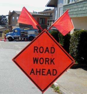
Yesterday on NextDoor, someone wanted to know what was going on with so much PG&E activity in our neighborhood.
I was curious, too, and even more so because today I saw this outside my house – a fleet of PG&E trucks, complete with a porta-potty. I counted four large trucks, and an earth mover.
The earth-mover was parked way at the back, waiting.
There was even a truck blocking one of our garages. When we came out, the PG&E guy running the project offered to moved it if we wanted. As it happened, we didn’t need that garage today, so we said not to bother.
Two men were digging a hole near the house opposite.
I asked one of the PG&E men what it was about. They’d done a survey some time back, he said, checking for leaks. They were now fixing the ones where they’d detected a problem. He said they had already completed a couple of jobs.
After the terrible accident in San Bruno, I’m glad they’re being proactive here.
The earthmover came down by our house. I’m not sure why it was wearing so much jewelry.
The truck in front of my house tipped up, and the earthmover grabbed the soil. I presume they filled in the hole they’d dug.
Within a couple of hours, they were done and had moved on. The road was empty, the signs and traffic cones gone, and all was quiet.
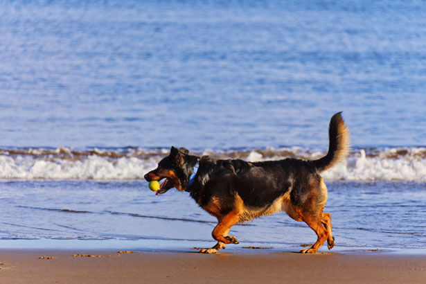
Recently, a neighbor out walking her dog encountered a large unfriendly dog that bit her dog so badly it required stitches. In the public interest, she would like this dog to be identified and asked me to put it here.
She writes:
Alfie was attacked by a grey Great Dane on January 24. His owner could not control him. When he finally got his dog off Alfie he left the scene showing no concern for my small dog.
If you know where the dog lives, please let me know – it will remain confidential. Animal Care and Control consider this a “bite and run.” We do not want it to happen to another dog, cat, child or adult.
If you respond in comments, we can pass it on to the neighbor.
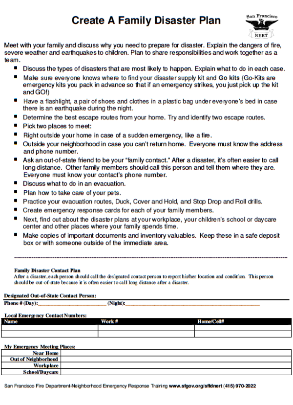
I don’t usually post twice on one day, but I think this is something people may find useful – especially after the recent wake-up call of the Napa Valley earthquake. I was browsing the NERT newsletter, and they had this 6-day preparedness plan for earthquakes.
No one can plan for every eventuality, but it’s reassuring to know one has made a good start. So here it is:
Start small. Just do one thing to get yourself prepared.
Every day!
DAY 1: put an old pair of comfortable shoes under your bed
DAY 2: Get a cardboard box to start your supply gathering
Day 3: House hunt, in your own house. Got a flashlight? Some bottled water? Extra roll of toilet paper? Maybe a radio? Think “what do I need if I get to stay in my home after an earthquake?” Put it in your box.
I was here in Forest Knolls when the Loma Prieta earthquake hit, with small kids at home. The children were watching Sesame Street or something similar. Suddenly, there was a quake. Then the power went out…
Knowing what to do (because it was part of the children’s training!) was valuable.
I received this letter from Diane Rivera, Coordinator Chair of the San Francisco Neighborhood Emergency Response Team (NERT), asking me to spread the word about NERT training.
Please join Mayor Edwin Lee, the Department of Emergency Management and the SFFD Neighborhood Emergency Response Team (NERT) in our efforts to reach all the people who live and work in San Francisco to learn about and register for the NERT training.
We find that citizens will take the NERT training outside of their neighborhoods as it fits into their schedules. Please publish all training dates if possible.
The San Francisco Neighborhood Emergency Response Team (NERT) is free trainingfrom the San Francisco Fire Department in how to help you, your family and your neighbors prepare for and respond to a disaster by working together. The 20-hour training taught by First Responders includes personal preparedness, light search and rescue, disaster medicine, shutting off your utilities, and how to participate as a member of a neighborhood response team.
NERT also offers continuing training for graduates and activities that support building robust neighborhood teams. For more information, visit the NERT website at http://www.sfgov.org/sfnert or contact Lt. Erica Arteseros at sffdnert@sfgov.org or 415-970-2022.
UPCOMING TRAINING CLASSES
(The schedule is updated on the NERT website training page whenever a new class is added.)
Numbers 1 and 2 are the full series of NERT training classes: six classes, given as 3 full-day sessions (at Civic Center) or 6 evening classes (at Duboce). Number 3 is a one-time, 2-hour workshop (at Noe Valley).
1) Civic Center,San Francisco Federal Bldg. 90 7th Street
September 23, 8:30a-4:30p: Class 1 & 2
September 30, 8:30a-4:30p: Class 3 & 4
October 7, 8:30a-4:30p: Class 5 & 6
2) Castro-Duboce Triangle – Davies, N. Tower Auditorium, Duboce Ave @ Scott St
October 9, 6:30p-10:00p: Class 1
October 16, 6:30p-10:00p: Class 2
October 23, 6:30p-9:30p: Class 3
October 30, 6:30p-10:00p: Class 4
November 6, 6:30p-9:30p: Class 5
November 13, 6:30p-10:00p: Class 6
3) Personal Readiness for a resilient Community: ONE TIME workshop for you and your neighbors!
Thursday October 23, 2014, 7:00pm-9:00pm
Noe Valley, St.Philip Church & School, 775 Diamond St @ 24th St
What’s in it for you?
You will learn the basics to take care of yourself and others. SFFD NERT and SAFE want you to have skills to be prepared for emergencies big or small, and get to know your neighbors on your block to maximize resiliency after a disaster.
Risk Awareness
Disaster supplies
Personal/Family Disaster Planning
NERT Overview
Disaster Pre-Planning – building community one block at a time
SFFD NERT and SFSAFE want you to have skills to be prepared for emergencies big or small, and get to know your neighbors on your block to maximize resiliency after a disaster. The San Francisco Neighborhood Emergency Response Team (NERT) is free training from the San Francisco Fire Department in how to help you, your family and your neighbors prepare for and respond to a disaster by working together.
NERT will be holding several new trainings in various neighborhoods in San Francisco during the month of June and July 2014. We find that citizens will take the NERT training outside of their neighborhoods as it fits into their schedules. Register on Eventbrite or call (415)970-2024 In addition, NERT will hold a Personal Readiness Workshop in the Ingleside and the Richmond Districts in June 2014.
The regular training sessions are once a week for 6 weeks. The 20-hour training taught by First Responders includes personal preparedness, light search and rescue, disaster medicine, shutting off your utilities, and how to participate as a member of a neighborhood response team. NERT also offers continuing training for graduates and activities that support building robust neighborhood teams. For more information, visit the NERT website at http://sfgov.org/sffdnert, or contact Lt. Erica Arteseros at (415)970-2022 or sffdnert@sfgov.org.
Bernal Heights
St. Kevin Church
702 Cortland Ave @ Ellsworth St.
Tuesdays
June 10 ~ July 15
6:30p-10:00p
RSVP for New Student – http://bit.ly/1j8BdER
RSVP for Recert – http://bit.ly/1kT8YcD
Nob Hill
St. Francis Memorial Hospital
900 Hyde St, Lower level, near Bush St.
Thursdays
June 19~ July 24
6:30p-10:00p
RSVP for New Student – http://bit.ly/1tahozD ;
RSVP for Recert – http://bit.ly/RUD317
Potrero Hill
St. Teresa’s Church
19th St @ Connecticut St
Wednesdays
July 16 ~ August 20
6:30p-10:00p
RSVP for New Student – http://bit.ly/1onD48w
RSVP for Recert – http://bit.ly/1oNQmyQ
And here are the one-day workshops:
Wednesday June 4, 2014
Supervisor Cohen hosts Sunnyside Community Center
1654 Sunnydale Ave
6:00p-8:00p
Enroll – http://bit.ly/1g1oi8m (Sorry, that was over before I got this posted)
Wednesday June 11, 2014
Supervisor Mar hosts Richmond Library Branch
351 – 9th Ave
6:00p-8:00p
Enroll – http://bit.ly/1gRWsEC
I got an email asking me to signal-boost three new Neighborhood Emergency Response Team (NERT) 6-session training series – and a one-time NERT workshop.
NERT will be holding one workshop and three (3) new training beginning February 13 and March 18, 2014. Please add our PDF flyer to your E-Newsletter/Website for the coming weeks. We find that citizens will take the NERT training as it fits into their schedule.
NEW! Personal Readiness for a resilient Community One time workshop for you and your neighbors!
WHEN:Thursday February 13, 2014 6:30pm-8:30pm WHERE: SFFD Division of Training 2310 Folsom St. enter through parking lot gate on 19th St http://bit.ly/KqZV4g
REGULAR NERT CLASSES
STARTING FEBRUARY
1) Noe Valley – Thursdays
Holy Innocents Church
455 Fair Oaks St @ 26th St
February 20, 6:30-10:00p: Class 1
February 27, 6:30-10:00p: Class 2
March 6, 6:30-9:30p: Class 3
March 13, 6:30p-10:00p: Class 4
March 20, 6:30p-9:30p: Class 5
March 27, 6:30p-10:00p: Class 6
Register: http://bit.ly/1cxowvc
2) Civic Center – Tuesdays
Hiram W. Johnson State Building (Identification needed)
455 Golden Gate Ave. @ Polk St.
Milton Mark Conference room, lower level
February 25, 8:30a-4:30p: Class 1 & 2
March 4, 8:30a-4:00p: Class 3 & 4
March 11, 8:30a-4:30p: Class 5 & 6
Register: http://bit.ly/1c57A3J
March 18, 6:30-10:00p: Class 1
March 25, 6:30-10:00p: Class 2
April 1, 6:30-9:30p: Class 3
April 8, 6:30p-10:00p: Class 4 school closed April 15
April 22, 6:30p-9:30p: Class 5
April 29, 6:30p-10:00p: Class 6
Register: http://bit.ly/1fn93kq
The San Francisco Neighborhood Emergency Response Team (NERT) is free training from the San Francisco Fire Department in how to help yourself and your neighbors prepare for and respond to a disaster by working together. The 20-hour training taught by First Responders includes personal preparedness, light search and rescue, disaster medicine, shutting off your utilities, and how to participate as a member of a neighborhood response team. NERT also offers continuing training for graduates and activities that support building robust neighborhood teams. For more information, visit the NERT website or contact Lt. Erica Arteseros at (415)970-2022 or sffdnert@sfgov.org.
I was sent this note by two of our neighbors. Though I don’t personally have a dog, I believe that dogs and their walkers make areas safer for *everyone* to use.
Why? It’s because dog-walkers are around. In all weathers, every day of the year, dogs need their walks. Who else uses the parks? Joggers do, but they usually go by running, often with their music on. So do hikers and trekkers and parents with their kids – but they usually select nice weather and convenient times. Dog walkers are the eyes and ears of our parks.
Paws in our parks means eyes in our parks.
So I’m pleased that our neighborhood is dog-friendly, and I’m happy to post this – for the dog-walkers, and for people like me who benefit from their presence. I’ve made some minor edits and corrected the deadline date.
SAVE OFF-LEASH DOG WALKING IN THE GGNRA!
What’s the Deal?
This past September, the GGNRA released a revised version of its Dog Management Plan in the form of the Supplemental Environmental Impact Statement, or SEIS. This document proposes eliminating 90% of off-leash dog access, and severely restricting all dog walking in 21 existing GGNRA sites in Marin, San Francisco, San Mateo counties, as well as in all future sites managed by the GGNRA.
Why Should I care?
If the GGNRA implements their preferred alternatives, Marin will lose off-leash access to the Oakwood Valley Trail, Muir Beach and almost all other GGNRA trails. The only off-leash opportunity in Marin would be Rodeo Beach, the one beach that is only reachable by car by any and all users. And most trails within the GGNRA in Marin would no longer allow any use by people with their dogs, leashed or unleashed. People and their dogs would go from having access to an already tiny 1 % of the GGNRA down to a mere .1 %, effectively removing an entire user group from the GGNRA.
Several years ago, when the plan was first unveiled, public comment ran 3-1 against the GGNRA’s preferred alternatives. But the GGNRA apparently isn’t listening. They’ve re-heated the same plan, with even more restrictions in many locations. And they are requiring new comments for the “new” plan. Even if you commented a couple of years ago, you need to do it again.
What can I do about it?
Comments close on 18 Feb 2014 at 11 p.m. [Webmaster; It’s been extended from January 11th, 2014]. You must submit substantive comments that directly address aspects of the SEIS. No form letters or petitions will be accepted or counted. The GGNRA is making it difficult for a reason. Comments mailed in the old fashioned way always carry more weight. We’ve tried to make it easy for you: key points/phrases to include in your comments are listed below. You may also comment on the NPS website, by clicking on the “Comment on Document” button. Here’s the link: http://parkplanning.nps.gov/document.cfm?parkID=303&projectID=11759&documentID=55416
HERE ARE SOME IMPORTANT POINTS TO MAKE IN YOUR COMMENTS
Mention where you walk, how long you ‘ve walked there, and what impact this will have on you as a dog guardian and as a citizen.
The SEIS lacks scientific data. Instead, it makes assumptions and assertions with absolutely no peer reviewed site-specific studies as required by law. Without these studies and corresponding data, there is no legitimate or legal foundation for these policy changes.
The plan doesn’t differentiate between impacts caused by humans or other animals. It just assumes all the negative impacts are caused by dogs.
If the GGNRA further limits dog walking as recreation, what few surrounding parks and trails that do allow off-leash will become overcrowded and overburdened. We need more access, not less.
A well-exercised dog is a well-behaved dog. The SFSPCA and Marin Humane Society, as well countless other dog behaviorists are opposed to GGNRA’s preferred alternatives.
There is no federally designated critical habitat in the GGNRA. Yet they cite possible impacts on critical habitat as a reason to ban dogs or restrict access to dog owners.
The GGNRA is an urban park, not a wilderness area. It’s critical recreational open space for a densely populated urban area. By severely reducing off leash dog walking, the GGNRA is in violation of its enabling legislation that allows different user groups -it specifically mentions off-leash dog walkers -to recreate.
Oppose the GGNRA’s preferred alternative and tell them you support the NO ACTION alternative.
Tell the GGNRA to enforce the existing (and adequate) rules to manage dogs.
For more info, visit saveoffleash.com
Send comments to: Frank Dean, General Superintendent Golden Gate National Recreation Area Fort Mason Building 201 San Francisco, CA 94123-002
SPREAD THE WORD! TOGETHER WE CAN KEEP THE GGNRA DOG FRIENDLY!
Sometimes, we need to leave our cars outside for convenience. If you’re doing that – bring your garage door opener inside. Thieves are breaking into cars, and snagging openers. As someone pointed out, a thief, can check the car’s registration papers to get the probable address. And then they’re into the garage and maybe the house.
I thought our neighborhood was pretty safe, but it happened on Devonshire yesterday. Here’s what a neighbor posted on our Yahoo Group:
Our car was unlocked last night, mistakenly, and someone opened it, got the garage remote and opened our garage door during the night. Apparently nothing was stolen except for the remote, but it’s scary and creepy. The same thing happened a few weeks ago, when the car was parked on a different street, and the remote was found a block away.
Let’s all keep a neighborhood watch –
PLEASE REPORT SUSPICIOUS PEOPLE and ACTIONS TO POLICE Non-Emergency Situations – 415-553-0123
Lock your house and your cars.
Keep the holidays safe and happy.
Thanks to the original poster for the heads up and the warning.