UCSF has revealed its plans for Aldea Housing. Back in 2014 when we reported that UCSF was removing Aldea student housing from the “space ceiling” that limited its expansion in the Parnassus area, we weren’t told what was planned. Now it’s been described in the 2020 DEIR (See the whole document here: UCSF-CPHP-Draft-EIR (1) ) Sept 11, 2020 is the last day for comments.
The plan is to demolish the existing low-rise wood-shingled buildings, and replace them with tall ones. The first phase will be three 8-storey and one 5-storey building. Here’s their impression from the DEIR document.
One of our concerns is that they’ll remove even more trees to accommodate the new buildings and the construction space to build them. We can probably expect most of the forest lying between Forest Knolls and the Aldea Housing to be thinned to the point that it is merely a few trees standing around instead of something resembling a wood.
I attended a meeting at UCSF’s Milberry Union last evening, 20 March 2019.
UCSF is rejigging its plans for Parnassus. After spending the last many years focused on its new location at Mission Bay, they want to come back to where it all started: Parnassus. They’re planning a new hospital by 2029, which will comply with new seismic codes. Beyond that, they want to improve the aesthetics of the Parnassus experience – create a sense of entry, strengthen the connection to Golden Gate Park and Mount Sutro, and build more space. They have a community group working on it, with mostly Inner Sunset residents and UCSF staff. (The list is here as a PDF: UCSF_Parnassus_Heights_Roster )
NEW PLANS FOR ALDEA
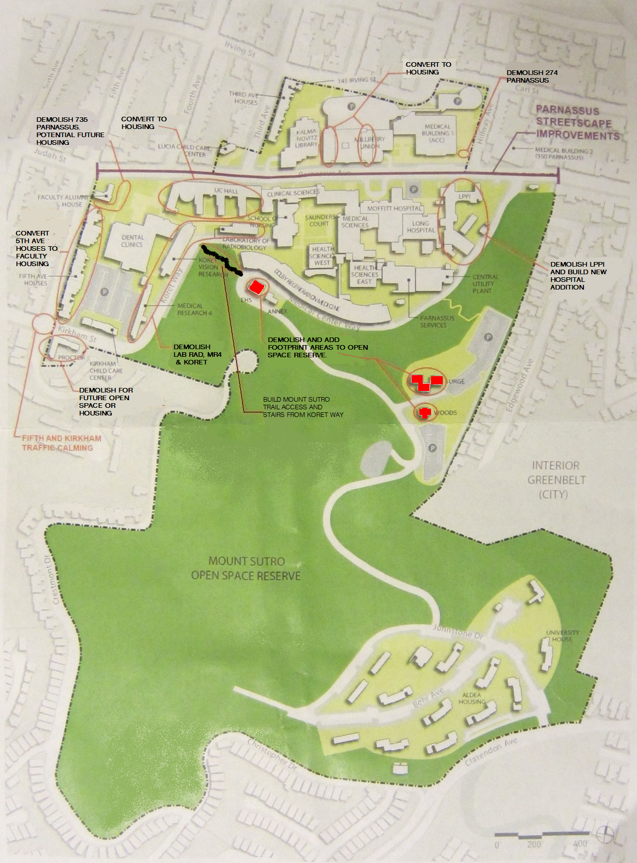
For those who aren’t aware of it, UCSF’s Aldea Student Housing adjoins Forest Knolls to the north just above Christopher Drive from Clarendon Avenue to where the forest is cut for the pipeline.
Among the plans to expand housing for students and staff, they are considering rebuilding the student housing at Aldea, from 171 units now to 500+ units when the project concludes. Aldea used to be subject to the “space ceiling” (explained in this post: UCSF’s Space Ceiling Saga) but apparently in 2014, the UC Regents decided to exempt it – as with all the other student housing.
To do this, they plan to replace their current, mostly 3-storied buildings, with 5-8 story buildings. They will probably start with the oldest ones, which are nearest to Forest Knolls.
For our neighborhood, it raises several questions:
Parking. As it is, a lot of UCSF people park in Forest Knolls and Midtown Terrace because of inadequate parking at Aldea and Parnassus. If the number of units at Aldea triples, what happens to parking?
Traffic. Aldea gives on to Clarendon at an awkward spot, just before the wide road up from Laguna Honda turns into the narrow one joining Twin Peaks Boulevard. Right now, Aldea doesn’t generate much traffic. But if it’s going to be housing 500 families? This is an area with NO amenities within walking distance – even a gallon of milk is a car-ride away. The connections to MUNI are also dismal. The only thing they have is the UCSF shuttle, down to Parnassus.
Aesthetics. Aldea is adjacent to Forest Knolls on the north. Right now, the Aldea buildings are low-key, low-rise shingled buildings partially hidden by trees. With plans for major tree removal as part of the “Vegetation Management Plan” for Mount Sutro, these buildings will be much more visible. The most recent structure at Aldea, the community center, is not very reassuring in terms of aesthetic inspiration. (See the boxy structure in the picture below.)
Time Line. I didn’t get a clear sense of the time-line on Aldea. There’s something on the last slide that suggests 2025 as the target date, which means they will move quickly. As a state organization, they don’t need city permission, and are exempt from the usual constraints on building.
THE PRESENTATION
I’m uploading a bunch of pictures I took of the presentation. They said that they would be putting it on their website, so hopefully you can get better quality pictures there soon. (I might download it here if it’s feasible.)
This article is taken (with permission) from the SaveSutro.com website. It says UCSF’s Plan for Mount Sutro – which could start as early as this winter – could directly increase the risk for our neighbors on Christopher and Crestmont.
I started thinking about it. It’s a pretty insidious. The cutting of trees, and widening of the road to use heavy machinery and trucks up above our neighborhood could have very long-lasting effects – for five to ten years after the project, according to the research. Nothing might happen immediately – and then along comes a really wet stormy winter and whoosh!
Is this something real estate agents will have to disclose? I don’t know. And if something does happen – what’s the insurance situation? (I’m not even going to think of the risk to families living there.)
Anyway, this article is to let our Crestmont and Christopher neighbors know about these concerns. There’s more about the UCSF 2017 Plan on SaveSutro.com
Recently, we wrote that the Sutro Forest 2017 Plan Imposes a Landslide Risk. A University of Washington study shows that mudslides are most like 5-10 years after trees have been cut down on slopes. The picture below shows the South Ridge, which will be directly affected.
But it’s not just the tree-cutting. UCSF is widening two major trails into roads fit for heavy equipment, and adding nine quarter-acre “staging areas” for machines and felled trees. Both the roads are above Forest Knolls. (The heavy yellow lines in the map below are the new roads. The red squares are the locations of the staging areas, each of which will be a quarter acre.)
The picture at the top of this article gives some indication of how steep the hillside is. And the roads above Forest Knolls are atop a slope *known* to be unstable. Look at this landslide hazard map:
The double black arrows show landslide direction. The wiggly black arrows show soil creep direction. All those dark green areas? Potentially unstable. All the gold areas? Also potentially unstable.
Though the Draft Environmental Impact Report claims it’s making safety its first priority – it doesn’t look like it. In attempting to mitigate one (overstated) concern (dead trees falling), they’re worsening the risk of landslides.
Yesterday, I was horrified to receive this letter from some Forest Knolls neighbors. This is re-posted with permission. We stand with them against hatred.
[Edited to Add: If you want to email them in support, please use this email address: TamayoLee2017 at gmail.com ]
Dear Neighbors,
First Amendment Rights are being threatened here in Forest Knolls.
We are writing to you to seek your support for ensuring that residents of our neighborhood can express themselves without threats or fear of harm. Since late 2014 or early 2015 we have had a Black Lives Matter poster in our living room window at 11 Christopher Drive. No incidents have occurred because of the sign.
However, in mid-July 2017 we received an anonymous note in the mail addressed to “RESIDENT, 11 CHRISTOPHER DRIVE, SAN FRANCISCO, CA 94131” with the message “BLUE LIVES MATTER! Get rid of your sign, or WE will!”. We did not take any action at that time.
However, another note was mailed addressed to ‘BLM, 11 CHRISTOPHER DRIVE, SAN FRANCISCO, CA 94131″ postmarked August 14, 2017 – the Monday after the tragedies in Charlottesville, VA — which stated “It’s time to replace your BLM sign. How about CHINK LIVES MATTER”. (“Chink” is an anti-Chinese slur originating from the turn of the 20th century.) We reported these notes to the FBI and to the SFPD Park Station on August 17. We surmise that the notes were from someone who passes by our house on a regular basis and is aware that we are of Asian descent.
We placed the BLM sign in response to a national concern that African-Americans were not only victims of deadly violence but also suffered ongoing discrimination and disparities in health, education, job opportunities, etc. In June 2015, nine African-American members of an African-American Methodist church in Charleston, South Carolina were murdered in cold blood by an avowed racist. And as the recent events in Charlottesville point out, our concerns of a rising intolerance to people of color and immigrants are not unwarranted. We are sharing this experience with you as our neighbors so that we can ensure that all our lives are safe and that we can all continue to exercise our rights to post the BLM sign or display any other political statement of our choosing. (The sign was taken down in August as a safety precaution for houseguests, but it will be back up very soon.) We also want to make sure that our neighbors and other San Franciscans are not silenced.
We have lived at our house since January 1993, nearly twenty-five years. We have enjoyed our home, tending our colorful flower garden, creating art on our side fence, walking in the newly expanded trails of UC’s forest and meeting others at the reservoirs/ Tank Hill with our dog as well as at Forest Knolls back bench social and summer street parties. We are natives of San Francisco and our children have attended SFUSD from kindergarten to senior year.
Debbie is a Senior Vice President for Futures Without Violence, a national non-profit addressing domestic and sexual violence and child trauma, where she has worked for over thirty-five years. She and her mother have tended our front garden over the last fifteen years. Bill is the District Director for the U.S. Equal Employment Opportunity Commission and earlier served as the EEOC Regional Attorney for twenty years. Civil rights protections are very close to our hearts and we have dedicated our whole professional lives to that cause.
We have contacted Supervisor Norman Yee’s office and plan to meet with him soon. We are open to your ideas and suggestions to send a message that our neighborhood supports First Amendment rights and will not allow residents to be intimidated with racist threats. If you want to post a Black Lives Matter sign or any other sign to express concern and/or outrage, please do not hesitate to contact us.
Thank you for your support.
Bill Tamayo Debbie Lee Celi Tamayo-Lee
This article is reprinted from SaveSutro.com with permission. The landslide hazard described touches our neighborhood; Christopher Drive and Crestmont are both in Forest Knolls!
This is risk that may actually increase over the years as a result of actions being taken now, for two reasons.
First, tree roots take time to die and rot, but when they do, they weaken the living geotextile that stabilizes the hillside.
Second, trees take up water and help to regulate moisture deep in the ground. When large trees are cut down and stop doing this, small saplings and ground cover are not an effective substitute. So if the trees are cut in dry or normal years, nothing may happen for a while – and then a really wet year can trigger landslides that would not have happened if the trees had remained.
Landslide under blue tarp. South Ridge at top left.
We’re reading the Draft Environmental Impact Report (DEIR) for the 2017 Sutro Forest Plan, and got to the section on landslide risk. This has been one of our concerns, especially since the tragedy at Oso, Washington, where the felling of trees in previous years was a factor in destabilizing the slope. (We wrote about that HERE: Cut Trees, Add Landslide Risk) We know this area is subject to landslides – we had a blue tarp covering unstable areas in Forest Knolls for a year when cutting trees destabilized a slope, and another just above UCSF’s Aldea housing area.
SHOCKING LANDSLIDE INFORMATION
We were shocked at what we found in the DEIR: “Increased instability could cause a landslide that would impact Crestmont Drive, Christopher Drive, and Johnstone Drive. An existing landslide scarp is visible above Christopher Drive. Some homes along Christopher Drive could be placed at additional risk from localized landslides due to plan implementation. Phase I activities would result in a potentially significant impact…”
The map above is taken from the DEIR. All the dark green areas are potentially unstable. All the gold areas are potentially unstable. All the cream areas are potentially unstable. The little red blobs and stars are already unstable. The black arrows show the direction of potential landslides – right into our communities. Here’s the key to the map. The light yellow and light green areas are where they are cutting down trees in Phase I (five years, starting this fall – 2017):
Legend to Landslide Hazard Map Sutro Forest 2017
What’s the proposed “mitigation”? Avoiding work in the forest for 2 days when the soil is wet after rain. This completely ignores the fact that landslides are a MULTI-YEAR hazard after tree removal.
Here’s the proposed mitigation in their own words:
“After a significant storm event (defined as 0.5 inches of rain within a 48-hour or greater period), the following conditions shall be met prior to any vegetation management activities:
The maps detailing areas of historic slope instability or rock fall in the Final Geotechnical and Geological Evaluation Report for UCSF Mount Sutro shall be reviewed (Rutherford + Chekene 2013)
If ground-disturbing or vegetation removal activities are proposed within or adjacent to areas of historic slope instability or rock fall, the saturation of the soils shall be estimated in the field; if muddy water drips from a handful of soil, the soil is considered saturated (Brouwer, Goffeau and Heibloem 1985)
The areas of historic slope instability or rock fall shall be flagged if the moisture content of the soils is determined to be high (i.e., muddy) and ground-disturbing or vegetation removal activities shall be avoided for a minimum of 48-hours after a significant storm event to permit soil drying…”
In other words, we won’t chop down trees in the rain or when the soil is wet.
Other mitigations are palliative. They’re planning to build roads into the forest for trucks and heavy equipment, and those roads will follow the contour of the slope. The quarter-acre staging plazas – where they’ll remove trees so trucks can turn around and heavy equipment be parked – will be flattish, with a slight slope for drainage. None of this is as effective as not building these roads or bringing in heavy equipment in the first place.
WHY THE MITIGATION IS MEANINGLESS
The problem is, the effect of cutting down trees is a LONG TERM problem. The effect of tree removal takes years – not days, not months – to fix. In Oso, Washington, the slope gave way three years after the last tree-destruction. Here’s the story (from the article we published at the time). The tragedy was foreseen… but the regulators thought they had enough mitigations in place.
On March 22, 2014, a huge landslide destroyed the small Washington community of Oso. Rain was of course a factor, as was erosion at the base of the slope. But it’s probable that tree-cutting above the slide area was an important factor too. An article in the Seattle Times that quotes a report from Lee Benda, a University of Washington geologist. It said tree removal could increase soil water “on the order of 20 to 35 percent” — and that the impact could last 16-27 years, until new trees matured. Benda looked at past slides on the hill and found they occurred within five to 10 years of harvests [i.e. felling trees for timber].
There had been red flags before. The area was second growth forest, grown back from logging in the 1920s/30s. Over 300 acres were again logged in the late 1980s.
The first time regulators tried to stop logging on the hill was in 1988. But the owner of the timber successfully argued that measures could be taken to mitigate the risk. Eventually, the state only blocked it from logging some 48 acres, and the owners gave in on that.
In 2004, new owners applied to cut 15 acres; when the Department of Natural Resources (DNR) objected, they halved the area and re-located the cut. DNR gave approval, subject to no work during heavy rain and for a day afterward. The tree-cutting finished in August 2005.
In January 2006, there was a major landslide 600 feet from the cut zone. The state built a log wall to shore up the slope.
The owners continued logging. In 2009, they removed 20% of the trees. In 2011, they removed another 15%. In 2014, the hillside collapsed.
The regulators were aware of the risk; they thought they were mitigating it with their restrictions and reaching a compromise with the owners. But it wasn’t enough. Destabilizing the mountainside is a long-term thing; the effects can show up in months, but it’s more likely to take years.
THE LESSON FOR MOUNT SUTRO
Our mountains not only are potentially unstable, they actually have landslides. The picture at the end of this article shows one on Twin Peaks, where rocks tumble after nearly every heavy rainy season.
The roots of the trees are helping to hold the unstable soil in place and that as the roots rot, landslide risk will increase. It is going to be more unstable 2-3 years after the trees are removed than 2 days after it rains. The information that instability increases over time is a little counter-intuitive.
Moreover, removing the trees takes away their ability to suck water out of the soil. If the tree-cutting is done in dry years, it may take a wet winter to trigger landslides… which would not have happened if the trees had been regulating the water and functioning as a living geotextile.
Since UCSF are not going to use herbicides on the stumps to prevent them from resprouting, they say they will grind the stumps. That is an effective way to prevent resprouting, but it will greatly increase the instability of the soil because the heavy equipment digs down several feet into the stump to destroy the roots. That’s another reason why they should not destroy trees where slide risk has been identified.
Anyone seriously considering the map above can only hope that UCSF will draw a better conclusion than the Washington State loggers and regulators. The planned destruction of thousands of trees – many within the first five years – could cause landslides in surrounding communities not days or months later, but years after the event.
But it didn’t proceed. Instead, it was put up for sale.
SF Overlook Project on a very steep slope – Google Maps image
FOR SALE AT $14 MILLION
In May 2015 SocketSite reported that the site was for sale, with the plans for the units (but without building permits).
In January 2016 they reported that the asking price, initially $20 million, had been cut to $15 million.
And in November 2016, they said the price had been cut to $14 million.
Hmm. According to a November 2016 mailing I received from realtor John Kirkpatrick, homes in the Forest Knolls neighborhood sold for an average of $1.195 million. Forest Knolls homes have 2 or 3 bedrooms and 1 or 2 bathrooms, but the back half of the garage typically offers customizable space. You can put in another 2 rooms and bathroom down there if you want. They’re standalone homes with no shared walls and most of them have a yard. That’s the competition to this project.
Let’s say these 29 luxury homes are priced at about $1.5 million, because they’ll have the latest fit and finish. Other benefits, like a 2-car garage and views are not unique to the development.
That would be a gross take of $43.5 mn, roughly 3 times the asking cost of the land and plans. Is it worth it? I don’t know.
ACCESS IS STILL AN ISSUE
Though there’s an agreement with the Mt Sutro Woods HOA, the project’s only access runs through the very narrow Crestmont Drive, which has houses on one side and a steep hillside on the other. Though on the map it looks like you could easily link it up to 5th Avenue, the intervening land doesn’t belong to the developer and is also very steep.
The way in to these 29 would-be homes is through the Forest Knolls neighborhood. Fears of destabilizing the mountainside where many homes are supported by concrete piers, fears of added traffic on an already narrow street, fears of potential emergency situations with very poor access, all could fuel more opposition.
Are you a short-term rental host? (AirBnB, VRBO, even on Craigslist – anything less than 30 days at a time) The city of San Francisco requires you to register. Walter Kaplan asked me to publish this PSA:
Forest Knolls residents who wish to act as a short-term rental host MUST register with the City’s Office of Short Term Rentals.The City is hosting a registration event at the Ortega Branch of the San Francisco Public Library on Thursday May 5, from 5:30 to 8:30 PM. There will be walk-in registration, and no appointment is required.
Here’s the original message from the city:
Hi. Here is the information on the upcoming (City-run) registration event at the Ortega Branch of the Public Library. Feel free to share with your neighbors.
Short Version: If you plan to host short-term rentals (including through websites such as VRBO, Airbnb, & Craiglist) in your home, then registration is required with the City’s Office of Short-Term Rentals. A walk-in registration event (no appointment required) will be held at the community room of the Ortega Branch Library, on the evening of May 5th from 5:30 PM to 8:30 PM. For more information visit http://www.sfgov.org/OSTR.
Long Form Version:
The San Francisco Office of Short-Term Rentals is offering additional opportunities to apply for registration as a Short-Term Rental host** or just to ask questions.
At the Ortega branch (3223 Ortega Street – meeting room) of the San Francisco Public Library on the evening of May 5th, from 5:30 PM to 8:30 PM. Walk-in registration (no appointment required). This is not a library sponsored program.
Walk-in registrations (no appointment required) at 1660 Mission Street (inside the Dept. of Building Inspection), on the 5th floor, on every Wednesday afternoon, between 1:00 PM to 4:00 PM.
Evening walk-in registrations (no appointment required) on the first Monday of every month, from 5:30 PM to 7:30 PM, at the Planning Department. Located at 1650 Mission Street, on the 4th Floor.
At the Earthquake Retrofit Fair on April 18th from 3:00 PM to 7:00 PM, at Bill Graham Auditorium, located at 99 Grove Street. No appointment required.
Registrations can also be handled, by appointment, on most weekdays (at 1660 Mission Street), and take about 20 minutes. Appointments are held at 1660 Mission Street, on the 5th floor. Appointments can be requested online at http://www.sfgov.org/OSTR.
Having a complete application and required documents (listed on Page 3 of the application form) can help speed up review and approvals after the registration event or appointment.
Registration is required with BOTH the Office of Short-Term Rentals AND the Office of the Treasurer & Tax Collector.
For more information on the application requirements, including documents needed in order to register visit http://www.sfgov.org/OSTR.
Hosting Short-Term Rentals WITHOUT being registered with the Office of Short-Term Rentals can result in daily fines. The City’s Administrative Code (Section 41A) requires registration if a permanent San Francisco resident would like to host short-term rentals in their home. To file a complaint about a Short-Term Rental, or if you have any questions please contact us at shorttermrentals@sfgov.org or (415) 575-9179.
**Short-Term Rentals are for stays of 30 days or less, that are hosted in residential dwellings. This includes if you offer stays in your home through the use of online platforms such as: Airbnb, Craigslist, Flipkey, HomeAway, and VRBO.
Regards,
OMAR MASRY, AICP | SENIOR ANALYST
Office of Short Term Rentals, City & County of San Francisco
omar.masry@sfgov.org
P. 415.575.9116 l F. 415.558.6409
1650 Mission Street | 4th Floor | San Francisco | CA 94103 http://www.sfgov.org/OSTR
The Sutro Stewards and UCSF are going ahead with plans to build the Clarendon connector trail, which would run inside the screen of trees that divides Forest Knolls from UCSF’s Aldea Housing. This is, coincidentally, the area that was severely thinned in August 2013. (Before picture above, after picture below.) This means that the actual trail probably will cause less destruction than it would have before. They hope to finish it by November 2016.
The trail would start on the Clarendon- Christopher corner, go into the narrow alley behind the pump house and fence, and continue on parallel to Christopher. (That’s the orange line on the map below.)
They’re also going to punch a new trail through on the South Ridge (the purple squiggly line), in addition to the Quarry Road Trail that was built with no notice to the community. These trails would not be bad, except that they always end up destroying trees – if not immediately, a year or two later when tree lining the trail are declared hazardous. Over 1500 trees have been removed since 2013, with around 350 being felled this last winter. There’s such a thing as too many trails for a 63-acre forest.
NEW TRAIL HEAD PLANNED
On March 14th, they had a meeting to design a formal new trail head at Clarendon x Christopher. (The red labels aren’t original to the picture, they’re just to orient you.)
The initial designs showed a seating area of granite, a kiosk with maps and signs, and gravel. The idea was to provide a well-marked entrance to the forest from the UCSF side (there is already one from the Stanyan side) that would avoid the campus, connect to new trails across Clarendon Avenue being built by San Francisco Recreation and Parks (SFRPD) near Sutro Tower, and have street parking available since UCSF has no plans to provide additional parking for this. They were looking for public input on what they wanted at the Trail Head.
Some of the ideas – seating, some kind of shelter from the wind that blows up Clarendon, a water-fountain, an earthen berm along the Christopher side to provide wind protection, permeable pavers on the ground instead of gravel.
So far, no funds have been set aside for this. It seems to be a fund-raising opportunity for the Sutro Stewards, who plan to write grant proposals for the money. UCSF may provide some funding too, but it is unclear how much. The team – the Sutro Stewards, and Julie Sutton of UCSF, seemed to want people to think big. Maybe that would justify a bigger grant?
CONNECTING TO OTHER SFRPD TRAILS
Lisa Wayne of SFRPD attended, to show how the new trail would link to three other trail projects SFRPD is working on: The Creeks-to-Peaks Trail from Glen Canyon to Twin Peaks (already being built); the plan to turn half of the figure 8 on Twin Peaks into a bicycle/ pedestrian area by restricting cars to the other half (in design); and trails to connect Twin Peaks to Mount Sutro via trails past Sutro Tower (yellow dotted line below – in planning).
She’s hoping to get work started this summer, for an opportunity to use VOCAL volunteers. Hope this doesn’t mean cutting down trees in the nesting season. Actually, not cutting down trees at all would be better, but trees are apparently the casualty of every SFRPD project, especially near any “Natural Area.”
CONNECTING TO THE BAY AREA RIDGE TRAIL
Several people from the Bay Area Ridge Trail group came, and Bern Smith spoke about how this new trail would connect to other trails and become part of a 550-mile trail system around the Bay.
WHAT DOES THIS MEAN FOR FOREST KNOLLS?
Quite aside from such issues as tree removal and thinning of the forest, this project will practically be part of our neighborhood. On the one hand, if there’s enough seating, it might make a picnic or gathering spot for a neighborhood that doesn’t have one. On the other – could this mean parking problems on nice days?
UCSF is taking comments. You can send them to Christine Gasparac: christine.gasparac@ucsf.edu
COMMENTS AT THE MEETING
The gallery below shows the comments from people at the meeting – which included a few members of the public, but no neighborhood representatives. If you click on the pictures, they should become legible.
A couple of days ago, neighbor Greg Flowers posted this on our Nextdoor site. (It’s reproduced here with permission.)
COYOTE SCARE
“After my experience last night, I plan to behave much differently when I am met by a coyote (or two) on the Sutro trails or on our neighborhood sidewalks. My usual MO is to respect its space and maybe snap a few photos of it as past encounters have been limited to in the woods of Mt. Sutro, and they usually run away.
“I took my dog out last night for a walk around the neighborhood around 10:45p following Christopher Dr east. As we were passing 15 Christopher, there was a rustle in the bushes and my dog lunged into the darkness. I pulled him back and we continued a few steps and then I saw it was indeed a coyote. It crossed the street into the woods and we made it to Clarendon before I turned and saw there were now two coyotes stalking us.
“Now I’m concerned and my dog is very interested in playing or giving chase. I tried to make myself look big and menacing, yelled a bit and made like I was going to charge them but they continued toward us so I then made the mistake of turning and continuing down Clarendon to get to Oak Park, looking over my shoulder constantly. No cars or people were out at this time and the fog + blood moon combo + coyotes stalking me really affected my nerves. The coyote in front crossed Clarendon as if it was planning to circle around to surround us and so when I got to Oak Park we turned the corner and sprinted all the way back to Christopher and Oak Park til we got home. That wasn’t the smartest choice but they didn’t follow me back into the neighborhood which was a huge relief.
“I’m posting this as a learning experience for myself and hoping it will help raise the awareness about the coyote presence around these parts. The closest I let them get to us was about 20 yards and my dog is 60lbs and these coyotes appeared larger than him. Because they were unaffected by my dog’s size and my scare tactic, I looked online and found this explanation of how to ‘haze’ coyotes so that they will fear humans again: Coyote Hazing: Guidelines for Discouraging Neighborhood Coyotes
“Hopefully we can make a neighborhood effort toward keeping coyotes, all our pets, and ourselves safe and that starts with coyotes maintaining a healthy fear of humans.”
A COYOTE WATCHER’S OBSERVATIONS
As readers of this site know, I’m a believer in coyote coexistence. This report was concerning, especially in the context of recent reports in which coyotes attacked dogs (one fatally) at Pine Lake (behind Stern Grove), a popular dog-play area. So I reached out to Janet Kessler, the Jane Goodall of San Francisco’s coyotes. She’s been studying our coyotes for years, and maintains a great blog, CoyoteYipps.com where she puts up her observations. Why were we suddenly getting this bold behavior?
“There seems to be a change in their behavior going on, but I’m told that it’s not due to habituation, it’s due to the drought. All urban coyotes are habituated by definition, yet they still keep a healthy distance (can’t use habituated and wary at the same time). For dogs, it’s a different story — and it’s going to be the same story whether a coyote is habituated to humans or not. Habituation to humans has nothing to do with coyotes approaching dogs — especially when they are curious about them.
“[Greg] did the right thing by moving away from the coyote — that’s how you diffuse a situation and maintain control — you are simply not going to engage. If a coyote follows… he’s just checking out your dog, gauging whether it’s a threat to be worried about, and making sure it is a safe distance away.
“We’re seeing more coyotes because of the drought. Because of the drought, there are fewer gophers and voles in the coyotes’ home range, so they are expanding that range as they hunt for their favorite foods. However, as they hunt in new areas, they will opportunistically take free roaming cats.”
This is also a concern; I know some people in Forest Knolls do have outdoor or indoor-outdoor cats. I think it’s also important for people with small dogs to be especially careful. Coyotes may see them as rivals or as prey, and they’re much more vulnerable. Humane Society guidelines recommend keeping cats indoors, and not letting small dogs off-leash in the backyard at night. Here’s their article: Coyotes, Pets and Community Cats.
From Janet Kessler: “And, yes, coyotes have been approaching dogs, much more than we’ve seen before. Walk away always, and keep walking (never run) away from the coyote, even if he follows.”
There’s more useful information on the CoyoteYipps website, here: CoyoteYipps.com
It also has some great photographs and observations of coyote behavior.
If you were thinking of going to tomorrow’s hearing about Sutro Tower (adding 50 antennae, removing an unspecified number of trees) – the hearing has been RESCHEDULED TO MARCH 19:
“The Zoning Administrator determined that further review of the existing site is needed with respect to the applicable Conditional Use Authorization. Therefore, we are continuing the Mandatory Discretionary Review hearing to March 19, 2015.”
I don’t consider myself particularly political. But in recent years, I’ve become aware of various kinds of community activism, and developed a real appreciation of what democracy means.
So I’m especially concerned about one Proposition that will be on the Ballot in November 2014. It’s Proposition I: Increased Usage of Children’s Playgrounds, Walking Trails, and Athletic Fields Act.
Prop I is being talked about as the opposite of Proposition H (opposing artificial turf on the Beach Chalet Soccer Fields), hence such campaigns as Yes on H/ No on Prop I.
But it’s not just that.
Here’s what I worry about: If passed, Prop I would sharply erode community voices in future decisions made by SF Recreation and Parks Department (SFRPD) regarding our parks and open spaces. It tips the scales strongly in favor of SFRPD.
WHAT IS PROPOSITION I?
Proposition I changes the Parks Code so that any major project that SFRPD forecasts will double usage in an calendar year gets the go-ahead once its Environmental Impact Report is certified. Here’s the proposition (as a PDF): Nov2014_ParkCode
Here’s what it does:
Applies to any SFRPD project concerning athletic fields, children’s playgrounds, or walking trails – which sounds like it would cover most SFRPD parks and open spaces.
Makes “doubles usage in a calendar year” as a benchmark – even if doubling usage isn’t a good objective or usage would fall after one calendar year. (And of course, since it’s about the future, it’s a forecast.)
Says that once such a project’s EIR has been certified, it “should be allowed” – presumably cutting off appeals, ballot measures and other community input.
It’s also got a “poison pill” for Proposition H. If it gets more votes that Prop H, then it invalidates Proposition H even if Prop H got over 50% of the votes.
Because of the “poison pill” some people are saying Proposition I is ‘the anti-H.’ However, its impact is much broader.
The Anti-Prop H Clause – Prop I – Nov 2014
MUCH WIDER IN SCOPE THAN JUST AN ANTI-PROP-H MEASURE
It allows SFRPD to proceed with any major project that they estimate will double usage in a calendar year, independent of the community’s desires or priorities. It removes nearly all means of appeal or review. So if this Prop I passes, then for any SFRPD project, they need only:
Pick any project and estimate it will at least double usage within a calendar year;
Hire a consultant to complete an EIR and agree that it will double forecast usage in a calendar year;
As long as the EIR is certified, SFRPD can implement the project without any community input or challenge.
Estimating doubled usage in a calendar year is enough reason?
WHAT ABOUT CEQA?
The California Environmental Quality Act (CEQA), which is what requires projects to get Environmental Impact Reports, is enforced through lawsuits. There’s no regulatory body.
It’s not clear whether Prop I would take away the right to a legal appeal, or to a ballot measure. But the way it’s worded, it could do so.
Even worse – the language specifies it shall be “liberally construed.” This could mean anything.
“Liberal Construction” – Prop I – Nov 2014
Prop I can also be amended by a two-thirds majority vote of the Board of Supervisors with the Mayor’s approval. It doesn’t need to go back to the voters. This means the Supes and the Mayor can change a lot of the wording afterward.
“Amendment” – Proposition I – Nov 2014
WHY THE SUPERVISORS MIGHT NOT UNDERSTAND
I know that City Hall is much in favor of Prop I. Seven supervisors signed to put it on the ballot, including Scott Wiener and David Chiu, both people whom I respect. Supervisor Wiener in particular feels it’s wrong for people opposing an SFRPD project to get more “bites at the apple” – after the Supervisors have approved it, and the EIR has been certified. I do understand that it’s frustrating when a multi-million dollar project is held up because a group of people in the community don’t want it.
What that argument doesn’t allow for is that the situation is inherently asymmetrical. The saying “You can’t fight City Hall” exists for a reason. All these rules – the Sunshine Act, the ability to go directly to the electorate via a ballot measure, the ability to take legal action – they all exist to redress the power imbalance, at least somewhat.
Theoretically, “City Hall” represents us. But a lot of things have to be weighed in any decision – from funds to feasibility to desirability of a project. And these can set up things so that what City Hall wants is not aligned with what the community wants.
Taking away avenues of recourse – including putting things on the ballot – feels efficient. But ‘efficient’ decisions are not always the right decisions.
JUST ABOUT SOCCER FIELDS?
Even though the main campaigners against Prop I are those who support Proposition H (and oppose artificial turf in Golden Gate Park), the issue is so much broader.
That’s why I hope that Prop I doesn’t pass, no matter what happens to Prop H.
I was talking to friends who plays soccer, and are willing to accept artificial turf as the price of play. “I’m voting No on H, No on I,” they said.
From where I sit it looks like Proposition I muffles the public voice about what happens in our parks.
I attended the UCSF quarterly Community Advisory Group meeting on Sept 3, 2014. The two topics of immediate interest to the Forest Knolls neighborhood are Aldea Student Housing and Sutro Forest.
ALDEA
Recently [Aug 12, 2014], UCSF had a meeting specifically to discuss removing Aldea student housing from the Space Ceiling. I reported on that HERE. At this meeting [i.e. the Sept 3rd meeting], they said they will go ahead.
Here’s the background:
In brief – following UCSF’s massive conflict with neighbors about its expansion plans, in 1976 the University of California Board of Regents passed a resolution that introduced a “space ceiling” that prohibited UCSF from expanding to more than 3.55 million sq feet of space in the Parnassus campus. The ceiling (which has been exceeded years ago, but still serves as a target and benchmark) does not apply to housing. However, Aldea Student Housing, which is next to Forest Knolls along Clarendon Avenue, was specifically excluded from the exclusion, meaning that it does count toward the space ceiling. UCSF wants to remove the restriction on Aldea Student Housing.
At the August 12th meeting, nearly everyone present opposed removing Aldea from the Space Ceiling. Here’s why:
Removing Aldea Housing from the space ceiling could trigger an expansion, limited only by funding availability. (Technically, UCSF as a state organization doesn’t even have to follow city codes – though they usually do try to comply.)
It would set a poor precedent in which the Board of Regents could remove any restrictions despite prior agreements with the community.
It ignored earlier commitments. When UCSF built the Stem Cell Research facility, it used about 0.5 acres of the Forest; it was going to demolish two dorms in Aldea Student Housing and return the area to the forest in compensation. Under the new proposal, this would not happen.
As Rick Osmon said in a comment to my earlier report:
“I was at the meeting on August 12. After it became clear that the neighbors who were at the meeting were in agreement that the Aldea housing should not be removed from UCSF’s overall space limits, Lori Yamauchi proposed adding language to the LRDP [Long Range Development Plan that would restrict any increase in density of units at the Aldea housing site. The biggest fear expressed by those at the meeting is that UCSF would embark on intensive development of the Aldea site. The [Associate] vice-chancellor’s proposal was welcomed by everyone I heard speak.”
At this CAG meeting, Associate Vice Chancellor Lori Yamauchi said they will ask the Regents to remove Aldea from the space ceiling. They think only a minority of the community oppose it. However, they were not asking for the repeal of the space ceiling as a whole.
They also said they would not increase the density of units at Aldea beyond existing levels. They only wished to retain the buildings they had earlier undertaken to knock down.
I found this reassuring. However, I met Lori later as we were leaving the building, and mentioned I’d be writing a report to the neighborhood on this website.
“You can say the LRDP has no plans to build more housing at Aldea,” she said.
“No plans to build isn’t the same as will not build,” I said. “Can you give a letter saying will not build?”
“I’m not prepared to negotiate that with the neighbors,” she said. (In all fairness, it was reasonable she wouldn’t give an undertaking then. It was an informal chat, as we were leaving the meeting.)
“But,” she added, “You can write a comment from the neighborhood.” She said they would be taking comments on the LRDP to the end of this month, and on the Environmental Impact Report until October 14, 2014.
You can email Damon Lew at dlew@CGR.UCSF.EDU and Lori Yamauchi at lyamauchi@planning.ucsf.edu
CREDIBILITY
One issue that was discussed was UCSF’s credibility. We’re all supporters of this great medical school. However, we have had numerous occasions when we thought we had a commitment… and found we didn’t.
I don’t think there’s a huge problem with retaining the dorms as they are. But I do think there’s a problem when UCSF undertakes something, and then pretty much decides to waive its decision. Situations do change, and there may be reasons to revisit earlier decisions. But it has to be done in consultation with the broader community.
OTHER ISSUES DISCUSSED
UCSF presented their ten-year capital plan (2014-15 to 2023-24), which included projects greater than $750,ooo in size. It totaled $1.6 billion, and included $460 mn of seismic safety work as well as some major building projects. (The presentation UCSF made, including these details, is HERE.)
They discussed minority hiring goals, and the EXCEL program that trained people from areas surrounding Mission Bay campus. There was concern about the African-American hiring goals specifically, and whether UCSF was doing enough.
They hope to build a new building behind SF General Hospital (which is not seismically upgraded) to move staff currently in the old building.
They discussed the new helipad at Mission Bay, which will be commissioned in October/ November.
They are in talks about the Warriors planned stadium, which will be right behind the Mission Bay campus (and close to the pediatric Emergency Room), regarding traffic flows and security issues.
MOUNT SUTRO FOREST
There’s been another evaluation of the trees for hazard. They said they do a hazard evaluation every two years, and they will be removing trees by year end. They did not know how many trees they would remove. (This would be in addition to around 1200 trees removed in the last 13 months.)
They will putting in signs for mountain-bike riders, informing them that they must yield to hikers and joggers.
A new trail – “The Sunset Trail” is being included in the capital budget. (I think that’s the black line near the top of the map.) It will likely be built this year or next. They did not say how many trees (if any) they would remove now – or later, in consequence of the trail’s existence.
UCSF will be holding a meeting on September 22nd, 2014, to further discuss the Long Range Development Plan.
About a month ago, I’d posted about a UCSF meeting regarding its plans for the Aldea San Miguel student housing. (This is the UCSF area off Clarendon Avenue just up the hill from Forest Knolls – see map at the bottom of this post.)
I attended the meeting, in the beautiful Spanish-revival UCSF Faculty Alumni Building. The gathering was relatively small. Damon Lew of UCSF said they had sent out 2,000 postcards notifying people. I guess it’s summer.
BACKGROUND
At present, Aldea is currently included in the overall “space ceiling” that restricts UCSF from expanding over 3.55 million square feet in the Parnassus area. (I wrote about those details in an earlier post, HERE.) Now UCSF wants to remove the 130,000 sq feet of Aldea housing from the 3.55 mn sq feet space ceiling. It argues that other university housing is not included in the space ceiling, and Aldea is an anomaly that could be rectified. (UCSF has actually exceeded the space ceiling for years, but seems to use it as a sort of benchmark and target.)
From what I understood, UCSF wants:
Initially, to preserve 3 dorm buildings it wasscheduled to demolish by 2024 in order to reduce square footage and bring it closer to the space ceiling. It represents 42 units of housing.
Later, it could replace them (and others of the 12 buildings at Aldea) with larger and more modern housing units – or, if it’s outside the space ceiling, maybe even with offices or other work areas.
COMMENTS FROM THE PUBLIC
Here are some of the key comments:
Dennis Antenore, a UCSF Community Advisory Group member, said he didn’t support removing Aldea. However, he thought if the community fought it, there was a real threat that the UC Board of Regents could decide to abolish the Space Ceiling altogether. If UCSF recommended that, the Regents would undoubtedly vote in favor.
Walter Caplan of the Forest Knolls Neighborhood Organization pointed out that our neighborhood would be directly impacted by anything that was done at Aldea, and he opposed removing Aldea from the space ceiling. He considered removal essentially giving UCSF a blank check for expansion in that area.
UCSF’s Lori Yamauchi responded by pointing out that even with the space ceiling, it didn’t limit Aldea to its current size; they could demolish elsewhere and expand in Aldea.
UCSF’s Barbara Bagot-Lopez said that when UCSF built housing elsewhere, it did so in consultation with the neighbors. As a state institution, they are not bound by city regulations about height limits, but they did observe them anyway out of respect for the community. So if they did decide to expand in Aldea, they would do the same thing.
Craig Dawson (Sutro Stewards, and also a member of UCSF’s Community Advisory Group -CAG) opposed removing Aldea from the space ceiling for several reasons. First, it would affect UCSF’s credibility; Aldea was included in the space ceiling for a reason, even when other housing wasn’t. Moreover, the demolition of 2 Aldea buildings were specifically included as an offset to the new Stem Cell research building, which took in 0.5 acres of the Forest. Finally, he said, it’s not a suitable place to expand housing, with no public transport or neighboring community. He also felt UCSF had not kept to the undertakings made in the previous Long Range Development Plan of 1996.
Lori Yamauchi disagreed vehemently; she said UCSF worked in good faith with the community, and though they may not have done everything they said (mainly demolition of some buildings), they were working to achieve the same goals.
Serena, a student of UCSF who lives at Aldea, emphasized how important housing was to students. She left a well-paid Federal job and came to San Francisco a full three months before her course started, only to ensure she got into housing. She pointed out that medical students make good neighbors, and add value to society. We should be supportive.
Several in the group agreed with her on both counts.
Bob (didn’t get his surname) asked what UCSF meant by “community.” Did it consider people like him, who were just residents of the area?
I thought that was an excellent question. UCSF calls the Community Advisory Group the “backbone” of its community engagement – but that’s a hand-picked group, many of whom have been on the CAG for years if not decades. It also refers to neighborhood organizations, but those often have the same structure. It’s important, in my opinion, to get the voices of the broader community – people who may not have the time to attend numerous meetings over many years, but nonetheless care about and are impacted by UCSF decisions.
Another person whose name I didn’t catch thought UCSF should keep its promises to neighbors, and consider the ripple effects of its actions on the neighborhoods – for instance, making parking impossible to get.
I am fine with delaying the demolition of the 3 dorms and preserving the 42 units beyond year 2024, but removing Aldea from the Space Ceiling is too open-ended of a change. From UCSF’s viewpoint, it probably is not worth the loss of credibility nor the potential conflict with the neighborhood. I also think it’s probably true that the Regents would agree to whatever UCSF proposes. But in my opinion, it’s for UCSF to avoid proposing something the community opposes. It shouldn’t be our responsibility to calculate whether the Regents would or wouldn’t support us.
I was surprised (and rather flattered) to find the photograph from our Forest Knolls site used on the opening page of UCSF’s presentation! For the record – I have no objection to their using this image.
SENSE OF THE MEETING
This is my sense of the meeting as it ended:
Almost everyone was opposed to removing Aldea from the space ceiling; even Dennis Antenore, who said the community should not oppose it, was not in favor. He just thought it might be a compromise.
Everyone understood the need for housing, especially below market-rate housing, for students and faculty near their place of work. Post-docs and doctoral students are paid between $32,000 and $45,000 annually – not enough in San Francisco’s rental market. It also reduces the need for commuting and thus reducing congestion and energy needs.
There was little opposition to retaining the 3 dorms scheduled for demolition.
There were concerns about UCSF and its undertakings to the community.
UCSF should not rely only on the CAG for its definition of “Community” but should broaden the viewpoints represented.
SEND COMMENTS AND OPINIONS
UCSF is in the process of making its Long Range Development Plan (LRDP), about which I posted HERE and HERE. It covers all the physical changes they plan for the Parnassus area (including of course the Aldea segment). The EIR is due out this Friday, Aug 15th, 2014. The UCSF website with all the LRDP information is HERE. They will be accepting comments on the LRDP and the Environmental Impact Report (EIR) on it to October 14, 2014.
You can email Damon Lew at dlew@CGR.UCSF.EDU and Lori Yamauchi at lyamauchi@planning.ucsf.edu
Forest Knolls would be impacted by changes at UCSF’s Aldea San Miguel housing
UCSF has announced a meeting to talk about its plans for the Aldea San Miguel campus housing.
This is a cluster of wood-shingled buildings nestled at the foot of Sutro Forest, amid tall trees and landscaping. The house of the UCSF Chancellor is also in the same complex. It’s a charming place with almost a mountain-resort feel to it. It’s adjacent to our neighborhood, lying between Cole Valley and Forest Knolls and is approached from Clarendon Avenue and connects to Parnassus Avenue by Medical Center Way, a short winding route that resembles a country byway.
BACKGROUND
UCSF is in the midst of its Long Range Development Plan, which will be valid for 20 years. They expect to adopt it in November 2014.
In the 1970s, UCSF made an agreement not to expand in the Parnassus area. The Regents voted to impose ‘space ceiling’ that limited their space in the Parnassus areas to and also not to acquire any properties in the surrounding areas. (I attended a meeting in Feb 2014 and reported on that HERE.)
Here’s some background from one of my earlier posts.
“Back in 1976, UCSF had a strategy of stealth acquisition. It quietly acquired a bunch of houses (mainly in the 4th Avenue and 5th Avenue area in the Inner Sunset), used some eminent domain, and planned to knock them down and expand. It was trashing the neighborhood, and the neighbors revolted. The battle was bitterly fought, and went all the way up to Sacramento. When the smoke had cleared away, UCSF agreed to limits to growth in the neighborhood. The UC Regents passed a resolution. This had several important impacts on Forest Knolls.
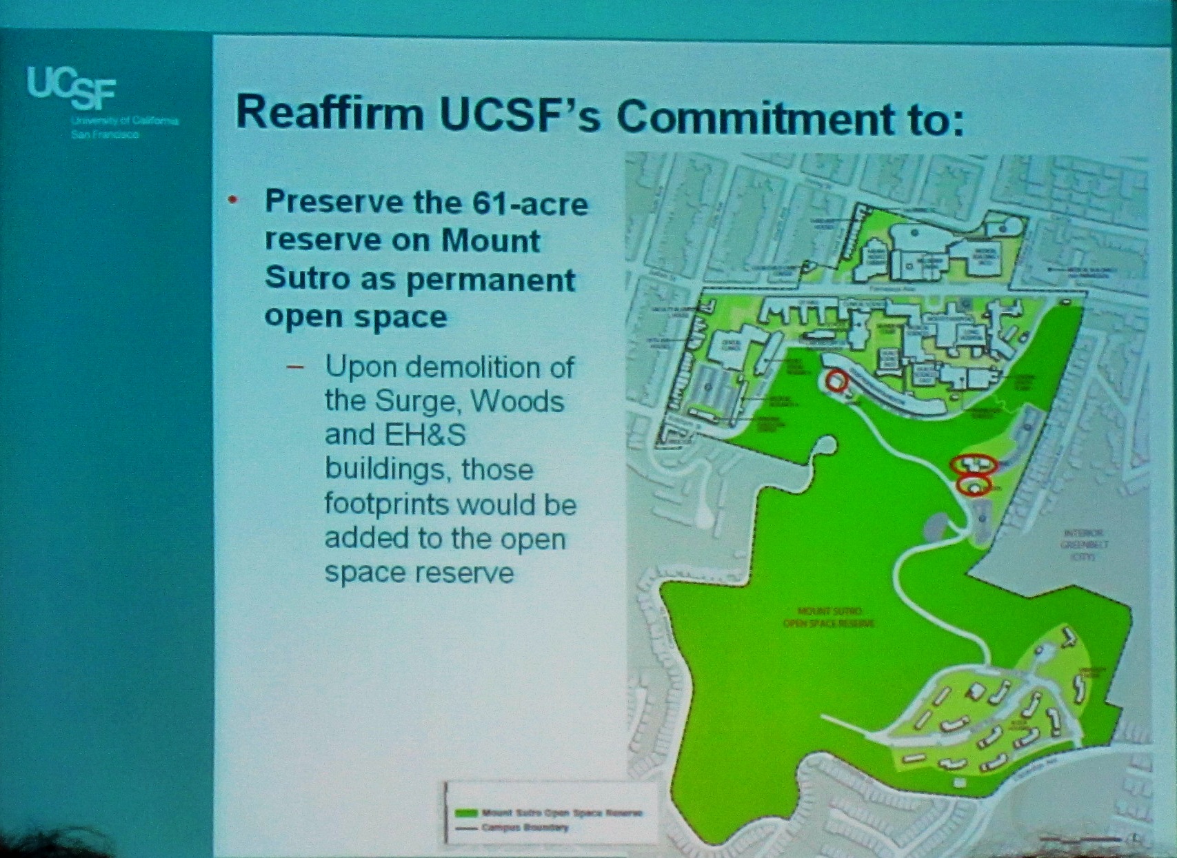
It agreed to maintain the 61 acres of Sutro Forest as an Open Space. They weren’t going to build on it.
They imposed a limit – 3.55 million — on the total square footage in the Parnassus area. If they built something new, they would knock down something else.
They defined an expansion restriction area in which they would not acquire properties (they cannot accept gifts of properties in this area either. This restriction area – the map in the photo above – includes Forest Knolls (the line ends at Clarendon).
Recognizing that the influx of people (with the transport requirements and other pressures they bring) was also impacting neighborhoods, they included a goal of limiting the population to 13,400.”
WHAT’S UP NOW?
In fact, UCSF soon exceeded the space ceiling. They’ve also exceeded the people limit. (Details HERE.) But they have kept to points 1 and 3, maintaining Sutro Forest as open space, and not acquiring properties in the restriction area.
Student housing was explicitly excluded from the Space Ceiling, with the exception of Aldea Student Housing. Now, UCSF is considering excluding that, too.
What does that mean? I don’t know for sure. I’ve heard people say it could mean knocking down the old dorm buildings, and replacing them with something more modern. Probably not prettier, if the Hall they built a few years ago is any indication. Could it also be bigger? I don’t know. It depends on how they interpret their earlier undertakings – or how they choose to reinterpret them.
Will it impact the forest? It’s possible. In the last “fire safety” action, UCSF removed around 1,000 trees and all the understory on areas around the Aldea campus. This has made the forest in these areas much drier and less healthy, especially after drought conditions.
Will it impact Forest Knolls? Now that the forest between Forest Knolls and Aldea has been thinned to the point that Aldea is easily visible from Forest Knolls, whatever they do in Aldea will have more visual (and audible) impact on our neighborhood. What further impacts it may have I’m not sure.
Here’s the meeting announcement from UCSF. If you have concerns, it may be worth attending.
UCSF’s last Long Range Development Plan (LRDP), created in 1996, was designed to guide the university’s physical development through 2012. UCSF has embarked on its next LRDP, which has an expected planning horizon of 20 years. Community involvement is a key facet of this planning process.
This meeting will focus on the UCSF Aldea San Miguel housing complex. Information regarding past agreements with the community and current proposals within the draft LRDP will be discussed.
Date: Tuesday, August 12, 2014 Time: 6:30pm Location: Faculty Alumni House, 745 Parnassus Avenue @ 5th Avenue, San Francisco, CA
UCSF strives to ensure maximum public involvement in this important planning process. With an open and interactive process — identifying the best ideas and ensuring that all points of view are considered.
The UCSF Faculty Alumni House can be accessed by several MUNI Lines: #6, #43 and N-Judah. Parking is available in the Kirkham Avenue parking lot near the corner of Kirkham and 5th Avenue.
UCSF fully ascribes to the Americans with Disabilities Act. If at any time you feel you have a need for accommodation, please contact UCSF Community & Government Relations at 415-476-3206 or community@cgr.ucsf.edu with your suggested accommodation.
I just got an email from the SFMTA with updates to proposed route changes. “Your participation has made a difference!” it said. It continued with an explanation of the changes proposed by the Policy and Governance Committee (PAG).
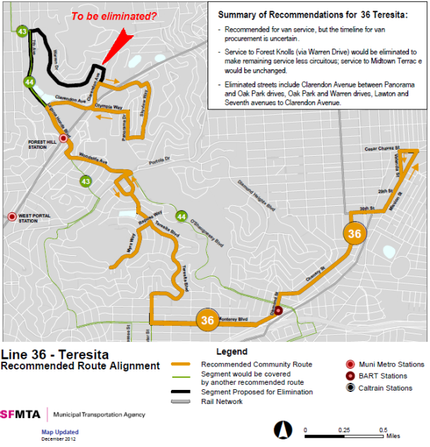
Among them:“36 Teresita: The PAG supports maintaining the entirety of the existing 36 alignment.”
Thanks, everyone who spoke up, commented, and wrote in against the original plan and particularly to those who spearheaded this effort. Clearly, our voices were heard.
[Special thanks also to our District 7 Supervisor, Norman Yee, for his assistance.]
Here’s the text of the whole message, in case you’re interested in other routes. There’ll be a meeting on March 28th, 8 a.m. at City Hall during which the final decision will be made. It’s expected to be in line with the recommendations.
Your participation has made a difference!
The service change proposals of the Transit Effectiveness Project, an ongoing project to make Muni more reliable for its customers, were reviewed by the SFMTA Policy and Governance Committee (PAG) on Friday, March 21. Based on their input, staff is recommending the following proposal modifications outlined below. Staff will present the following recommendations to the SFMTA Board on Friday, March 28. These modifications aim to retain the benefits of the initial proposals, while addressing key community concerns.
Here’s what we proposed, what we modified based on what we heard, and what we will be recommending to the SFMTA Board:
2 Clement: The PAG supports the recommended proposal of using existing overhead wires to implement 2 Clement trolley service on the entire Sutter/Post Street corridor, adding service on the Sutter Street route segment, and realigning the 2 line to operate on California Street to Eighth Avenue, on Eighth Avenue south to Clement Street, on Clement Street between Eighth and Sixth Avenues, and to California via Sixth Avenue. Service will be discontinued on Clement Street; between Arguello Boulevard and 6th Avenue, and 8th and 15th Avenues.
3 Jackson: The PAG supports maintaining service on the 3 Jackson with reduced frequency to better match customer demand.
6 Parnassus: The PAG supported maintaining the 6 Parnassus in the line’s current alignment through Ashbury Heights to UCSF and Golden Gate Heights and to reduce the frequency of the line to better match customer demand west of Masonic Avenue. Service will be further increased on the 71L Haight/Noriega Limited.
8X Bayshore Express: The PAG supports the continuation of 8X service north of Broadway for every other trip.
10 Townsend: The PAG supports the current 10 Townsend (Sansome) proposal to reroute through Mission Bay.
17 Parkmerced: The PAG supports the revised 17 realignment proposal, which shifts service to portions of Lake Merced Boulevard and Brotherhood Way to access the Daly City BART Station.
22 Fillmore and 33 Stanyan: The PAG supports the original realignment proposals for these routes, which include realigning the 22 along 16th Street to provide a direct transit connection to Mission Bay and realigning the 33 Stanyan off of Potrero Avenue and along the former 22 Fillmore alignment into the Dogpatch neighborhood. The PAG also supports increasing 33 service from 15 minute service to 12 minute service all day.
27 Bryant: The PAG supports maintaining the entirety of the existing 27 alignment.
28/28L 19th Avenue: The PAG supports the revised proposal for the 28 and 28L, which calls for the termination of the 28L in the Richmond District to Park Presidio and California Street and extension to the Balboa Park BART Station and the Mission corridor, as well as the continuation of the 28 to the Marina District via the Golden Gate Bridge to a new terminal at Van Ness Avenue and North Point Street.
35 Eureka: The PAG supports the revised proposal for the 35, which includes the continuation of service on Moffitt, Farnum, Addison, and Bemis Streets, and the extension of service to the Glen Park BART Station via Miguel and Chenery Streets.
36 Teresita: The PAG supports maintaining the entirety of the existing 36 alignment.
43 Masonic: The PAG supports connecting the route with the Presidio Transit Center while maintaining the existing route segment on Letterman Drive and Lombard Street.
47 Van Ness: The PAG supports maintaining 47 line service on 11th Street between Mission and Bryant Streets, rather than on 13th Street as originally proposed.
48 Quintara/24th Street: The PAG supports the original 48 service change proposal to remove service in the vicinity of Hoffman and Grandview Streets and instead straighten service along Clipper and Douglass Streets. However, the PAG supports maintaining the 48’s current alignment until the new 58 24th Street route is introduced, which is proposed to serve the former 48 alignment along Douglass Street, 21st Street, and Grandview Avenue.
56 Rutland: The PAG supports maintaining the entirety of the existing 56 alignment.
What’s next? See your input in action!
Proposed service and route changes to be reviewed by SFMTA Board of Directors at the following upcoming public hearings at City Hall Room 400, 1 Dr. Carlton B. Goodlet Place
Friday March 28, 2014 at 8am
TEP Service change recommendations will be presented. (SFMTA board will make decisions at this meeting)
A few weeks ago, I wrote about SF MTA’s plans to leave our steep and hilly area without public transportation by dropping the Forest Knolls loop of the 36-Teresita bus. (And this is after the previous battle to save this line, which ended with frequency being reduced from 20 minutes to 30.) Neighbors have been fighting this plan. The Forest Knolls Neighborhood Organization has joined the battle to save the bus route, and has some great suggestions about how you can help. Here’s their flyer:
FOREST KNOLLS NEIGHBORHOOD ORGANIZATION
MUNI plans to eliminate the Forest Knolls loop of our 36 Teresita bus.
Proposed service and route changes will be reviewed by SFMTA Board of Directors at a public hearing this Friday March 14, 2014 at 9am in City Hall, room 400.
TEP Informational Hearing – staff will present proposals from feedback gathered at recently held community meetings. The SFMTA Board will then take additional testimony from the public on proposed route changes.
It is important that Forest Knolls residents appear at this hearing to make known their strong objection to the proposed elimination of MUNI service to our Forest Knolls neighborhood.
Please plan to attend the meeting this Friday March 14 at 9 am in City Hall, room 400.
The SFMTA Board responds to community participation – we must be present in large numbers to voice our objections. Plan to attend this important hearing if at all possible.
E-mail your opposition to http://www.tellmuni.com and tweet SFMTA (@sfmta_muni) to make your opposition known. Also e-mail your opposition to the Planning Manager of MTA’s “Transit Effectiveness Project” Sean Kennedy: sean.kennedy@sfmta.com and call our supervisor (Norman Yee) at 415-554-6516 to seek his assistance.
Meanwhile, neighbors have been talking to the SF MTA – which seemed responsive, but has not published any planned changes (which it has made to its plans for other routes). Here’s what Joe Humphreys wrote to update us:
The SFMTA had a public meeting on February 25th at San Francisco State. Forest Knolls was well represented with a number of neighborhood residents raising substantial protest to rerouting the 36 line to no longer include Warren Drive. It appeared at the meeting that the SFMTA staff understood and were sympathetic to the concerns raised. However, they announced today a number of changes that they had made to the staff’s proposed “Transit Effectiveness Plan” Apparently, however, what they are recommending does not include keeping bus service in Forest Knolls as the 36 line is not one of those where they indicated some accommodation to public concerns. This announcment is here : http://sfmta.com/news/project-updates/tep-service-change-proposals-revised-based-community-feedback .
The West of Twin Peaks Central Council – which is a “Council of councils” comprising twenty different neighborhood organizations, passed a Resolution in Support of the 36-Teresita.
A Resolution in Support of the 36-Teresita By: The West of Twin Peaks Central Council
PASSED UNOPPOSED
WHEREAS, It is clear that the San Francisco Muni is looking to cut or severely curtail service on the 36-Teresita Bus line in their upcoming budget meeting: and
WHEREAS, there have 6 independent West of Twin Peaks Central Council Member Neighborhoods [The Woods, Galewood Circle, Forest Knolls, Midtown Terrace, Mount Sutro Woods and Sherwood Forest] on steep hillsides that depend exclusively on the 36-Teresita as the only Muni connection to the rest of the city and the Bay Area: and
WHEREAS, these neighborhoods are filling up with new families with children that need the 36-Teresita to get them to and from school: and
WHEREAS, the elderly residents of these neighborhood depend on the home health care workers that come to them via the 36-Teresita Bus to make it possible for them to stay in their homes for as long as is possible:
Now, therefore,
BE IT RESOLVED: that the West of Twin Peaks Central Council assembled this 24th
day of February, 2014, in the City of San Francisco, California, urges the Muni to see the immense value that the 36-Teresita Muni bus line contributes to the residents, visitors, commerce, and children of the above mentioned neighborhoods and the city as a whole: and
BE IT FURTHER RESOLVED that the Muni should keep the current 36-Teresita service available to these taxpayers who crowd this line at commute times and depend on it as a lifeline in this increasing congested city.
We hope that SFMTA is listening. Please attend the meeting if you can, and also send in your comments to tellmuni.com, to sean.kennedy@sfmta.com, and to our District 7 Supervisor Norman Yee.
About a year ago, Joe Humphrys warned us that the SFMTA was planning to abandon the Forest Knolls section of the 36 Teresita bus service. I wrote about that HERE, and Joe contributed a post HERE.
So, it’s happening, unless the neighborhood manages to get SFMTA to re-think this. The public hearing is on Feb 25th, 2014. (I got another message from Joe, with a link to the public hearing notice.)
Date: Feb 25th, Time: 6 p.m. Where: San Francisco State University,
Seven Hills Conference Center,
800 Font Blvd., San Francisco, CA 94132
And then Sara Lu wrote a note. This is important, because clearly if anything is going to change, it will need to come from neighborhood pressure. Otherwise, our bus is gone. Here’s her note (with minor edits and added emphasis):
[Webmaster: This is similar to the map at the top of this post, available as a PDF here: rte_036_BW]
Muni proposed to change route 36 by eliminating stops include Clarendon Avenue between Panorama and Oak Park drives, Oak Park and Warren drives, Lawton and Seventh avenues to Clarendon Avenue. This means no bus will come through Forest Knoll at all, which is completely unacceptable.
I sent in my objections on Muni’s website (http://tellmuni.com); but a singular post is not going to make the difference – we will need as much neighborhood support as possible. I strongly recommend posting the subject on the Forest Knoll website and throughout the neighborhood, encouraging as many residents to attend the public hiring on Feb 25 (6pm) and post on tellmuni feed back as possible.
I am a daily rider on the 36 bus from Devonshire and Warren drive. Route 36 is the only form of public transit through the Forest Knoll neighborhood. For daily commuters like myself and the many elderly residents in the neighborhood, it is the only form of connection to Forest Hill Muni station. A 30-minute bus frequency is already inconvenient enough; eliminating the route through Forest Knoll is completely unacceptable. It will leave the entire community stranded, without any feasible form of public transportation.
The proposed alternative is not at all realistic. Walking to 7th and Lawton or Clarendon may not seem terribly far on flat map; but anyone who knows the area topography would know, the Forest Knoll neighborhood is on a very steep hill. In fact, it is one of the highest points in San Francisco. It is impossible for any elderly resident to talk from the proposed alternative stops (20-30 minutes straight uphill); and completely impractical for daily rider like myself. I, as well as most residents, cannot afford to drive and park in downtown San Francisco, and have no intention to add to the congestion on the road.
I am trained as an urban planning, and fully support public transportation. Leaving a whole neighborhood/community without any form of accessible public transportation is not acceptable.
What would you propose we can do to make sure our neighborhood is not overlooked?
The only way to stop this is to protest. As Sara Lu points out, a few posts will not make a difference, but a whole lot will.
Please go to tellmuni.com and explain that there’s a lot of difference between a healthy young person strolling on a level street, and forcing elderly people to climb 30 minutes up one of the steepest slopes in San Francisco.
Please attend the hearing if you can and make your voices heard.
From time to time, I attend UCSF’s Long Range Development Plan meetings. My main concern is the forest on Mt Sutro, but I’m also interested in what’s happening down at Parnassus. Yesterday, I learned more about the ongoing saga of the Space Ceiling. (My last report on that was HERE and it provides background on some of the issues.)
The Space Ceiling was a self-imposed limit to growth that UCSF decided on in 1976. [See that here:1976-regents-resolution ] That was when it got into a huge battle with its Inner Sunset neighbors as the University spilled out in all directions, and started changing nearby neighborhoods. At the time, the limit was set at 3.55 million square feet. By 1996, it was at 3.66 mn (or 6% over) with a plan to reduce it to only 2% over by 2012. Instead, by 2012, it was 8.2% over the limit, at 3.84 mn sq ft.
WIN SOME, LOSE SOME
What’s happened since? Three things, which left them with a tiny net increase in the space to 3.844 mn sq feet, or 8.3% over the Ceiling.
They knocked down the building at 735 Parnassus, gaining 2,766 square feet.
They gained another 3,121 sq feet when they converted the office building at 1486-1488 Parnassus to student housing, which doesn’t count against the space ceiling. (The only housing that counts toward the Space Ceiling are the student housing units at Aldea, up above Forest Knolls off of Clarendon Avenue.)
However, they also did a careful re-measuring of the existing square footage of the Parnassus campus. They found that two changes increased the actual square footage: They enclosed the Food Court, which made it an inside space instead of an outside space; and they converted a mechanical space in Moffet Hospital into an “occupied space.” They also found some of the old measurements were inaccurate. So all told, they found that the actual existing space had been understated by 10,700 sq feet.
It’s really difficult to start knocking things down mainly to get UCSF under the Space Ceiling, so while it’s doing some demolition, UCSF is also converting more space to student housing (which, as we said, doesn’t count). They expect to double the amount of student housing at Parnassus.
They are also going to ask the Regents to revise the Ceiling specifications so that Aldea housing doesn’t count either.
Here are the current plans:
Click on map for larger version
THE RESTRICTION ZONE
The other restriction on growth was on purchase or acquisition of properties in the “restriction zone” that includes Forest Knolls – see below. (UCSF’s aggressive acquisitions had been changing neighborhoods around it, and neighbors wanted it to stop.)
Anyway, UCSF reaffirmed their commitment to observing that Zone, but noted that they weren’t prohibited from leasing commercial properties, or affiliating with other public agencies in this area.
Here’s a closer view of the Restriction Zone. It includes Forest Knolls, Edgewood, Inner Sunset and Cole Valley.
OTHER ISSUES
They seem to have given up on the 16,000-a-day people limit. It’s crossed 18, 000 now. But they’ve promised an annual community meeting to monitor all the parameters.
Neighbors have been concerned with truck traffic, and UCSF did a traffic study. They’re looking for solutions like making loading/ unloading more efficient by having a permanent dockmaster stationed at Medical Center Way; using some of the demolished areas on Koret as additional truck parking, and consolidating deliveries elsewhere into UCSF trucks, so reducing the number of trips.
One commenter spoke about the problems of living next to the UCSF campus – glaring lights by the ammonia tank; 30-50 smokers daily, who were not allowed to smoke on UCSF’s Smoke-Free campus ended up under his window; noise from blaring radios on vehicles as they waited to move; and syringes being tossed over his fence. Not a great environment for his two small kids.
MOUNT SUTRO FOREST
Though the University wasn’t planning to discuss Sutro Forest, some of the changes planned will have a (apparently quite minor) impact on the forest. Also, supporters and opponents of UCSF’s current plan for Sutro Forest took the opportunity of this meeting to speak up. The report is HERE.
At this meeting, UCSF reiterated its commitment to keeping Mount Sutro as publicly accessible open space. (Some commenters had suggested that the University might have other plans.)
GOING FORWARD
Here are the milestones going forward. The LRDP is to be adopted in November 2014.
I just got the details of Supervisor Yee’s interesting plan for participatory budgeting that he mentioned at the West of Twin Peaks Central Council (WTPCC) meeting on January 2014. Read on:
YOUR IDEAS. YOUR VOTE. YOUR DECISION.
WHAT IS PARTICIPATORY BUDGETING?
Participatory Budgeting is a democratic process that gives community members the opportunity to set budgeting priorities and make decisions on what community projects should be funded.
HOW DOES IT WORK?
For the first time, District 7 residents will be able to help decide how best to spend $100,000 for general projects and $250,000 for pedestrian safety improvements in District 7.
KICK-OFF COMMUNITY MEETING
Saturday, February 22, 2014 | 10:30AM to Noon
West Portal Clubhouse | 131 Lenox Way (b/t Ulloa and Verdon)
Join Supervisor Yee and community members to learn more about Participatory Budgeting and the grant application process for projects. All District 7 residents are eligible to vote on the projects!
PROJECT PROPOSAL WORKSHOP
Wednesday, March 5, 2014 | 6:00PM to 7:30PM
Commodore Sloat Elementary School | 50 Darien Way (b/t Junipero Serra and San Rafael Way)
Learn more about the Participatory Budgeting process and how to develop your project ideas.
VOTE ON THE PROJECTS
End of April (Dates to be Announced) After proposals are finalized and submitted, community members like you will get to vote on which projects to fund!
I was sent this note by two of our neighbors. Though I don’t personally have a dog, I believe that dogs and their walkers make areas safer for *everyone* to use.
Why? It’s because dog-walkers are around. In all weathers, every day of the year, dogs need their walks. Who else uses the parks? Joggers do, but they usually go by running, often with their music on. So do hikers and trekkers and parents with their kids – but they usually select nice weather and convenient times. Dog walkers are the eyes and ears of our parks.
Paws in our parks means eyes in our parks.
So I’m pleased that our neighborhood is dog-friendly, and I’m happy to post this – for the dog-walkers, and for people like me who benefit from their presence. I’ve made some minor edits and corrected the deadline date.
SAVE OFF-LEASH DOG WALKING IN THE GGNRA!
What’s the Deal?
This past September, the GGNRA released a revised version of its Dog Management Plan in the form of the Supplemental Environmental Impact Statement, or SEIS. This document proposes eliminating 90% of off-leash dog access, and severely restricting all dog walking in 21 existing GGNRA sites in Marin, San Francisco, San Mateo counties, as well as in all future sites managed by the GGNRA.
Why Should I care?
If the GGNRA implements their preferred alternatives, Marin will lose off-leash access to the Oakwood Valley Trail, Muir Beach and almost all other GGNRA trails. The only off-leash opportunity in Marin would be Rodeo Beach, the one beach that is only reachable by car by any and all users. And most trails within the GGNRA in Marin would no longer allow any use by people with their dogs, leashed or unleashed. People and their dogs would go from having access to an already tiny 1 % of the GGNRA down to a mere .1 %, effectively removing an entire user group from the GGNRA.
Several years ago, when the plan was first unveiled, public comment ran 3-1 against the GGNRA’s preferred alternatives. But the GGNRA apparently isn’t listening. They’ve re-heated the same plan, with even more restrictions in many locations. And they are requiring new comments for the “new” plan. Even if you commented a couple of years ago, you need to do it again.
What can I do about it?
Comments close on 18 Feb 2014 at 11 p.m. [Webmaster; It’s been extended from January 11th, 2014]. You must submit substantive comments that directly address aspects of the SEIS. No form letters or petitions will be accepted or counted. The GGNRA is making it difficult for a reason. Comments mailed in the old fashioned way always carry more weight. We’ve tried to make it easy for you: key points/phrases to include in your comments are listed below. You may also comment on the NPS website, by clicking on the “Comment on Document” button. Here’s the link: http://parkplanning.nps.gov/document.cfm?parkID=303&projectID=11759&documentID=55416
HERE ARE SOME IMPORTANT POINTS TO MAKE IN YOUR COMMENTS
Mention where you walk, how long you ‘ve walked there, and what impact this will have on you as a dog guardian and as a citizen.
The SEIS lacks scientific data. Instead, it makes assumptions and assertions with absolutely no peer reviewed site-specific studies as required by law. Without these studies and corresponding data, there is no legitimate or legal foundation for these policy changes.
The plan doesn’t differentiate between impacts caused by humans or other animals. It just assumes all the negative impacts are caused by dogs.
If the GGNRA further limits dog walking as recreation, what few surrounding parks and trails that do allow off-leash will become overcrowded and overburdened. We need more access, not less.
A well-exercised dog is a well-behaved dog. The SFSPCA and Marin Humane Society, as well countless other dog behaviorists are opposed to GGNRA’s preferred alternatives.
There is no federally designated critical habitat in the GGNRA. Yet they cite possible impacts on critical habitat as a reason to ban dogs or restrict access to dog owners.
The GGNRA is an urban park, not a wilderness area. It’s critical recreational open space for a densely populated urban area. By severely reducing off leash dog walking, the GGNRA is in violation of its enabling legislation that allows different user groups -it specifically mentions off-leash dog walkers -to recreate.
Oppose the GGNRA’s preferred alternative and tell them you support the NO ACTION alternative.
Tell the GGNRA to enforce the existing (and adequate) rules to manage dogs.
For more info, visit saveoffleash.com
Send comments to: Frank Dean, General Superintendent Golden Gate National Recreation Area Fort Mason Building 201 San Francisco, CA 94123-002
SPREAD THE WORD! TOGETHER WE CAN KEEP THE GGNRA DOG FRIENDLY!
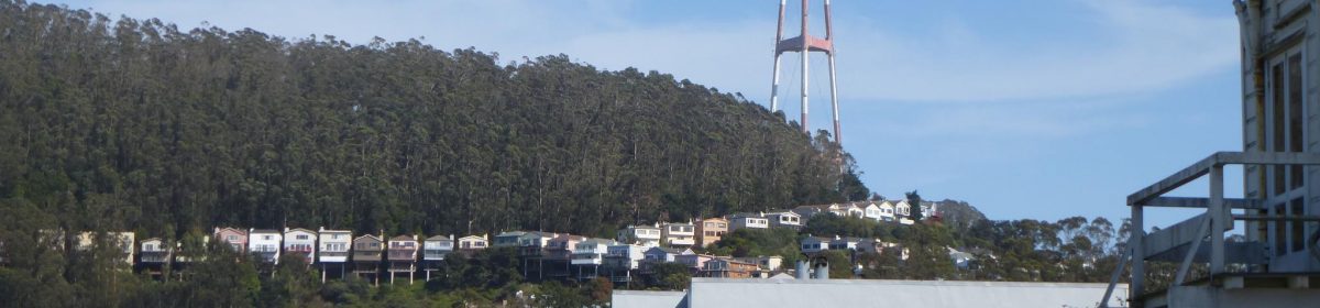
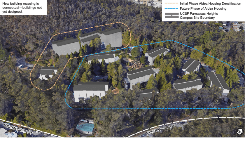
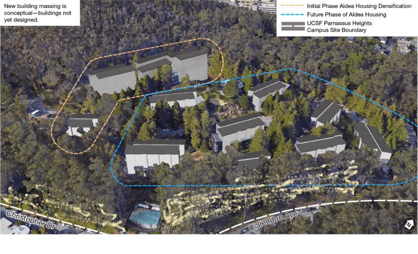
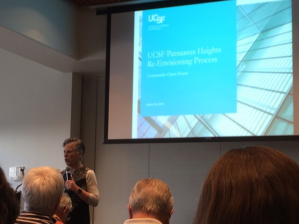
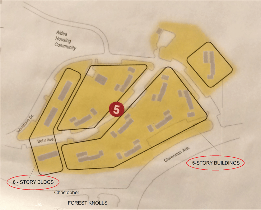
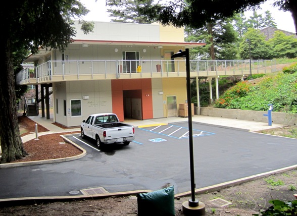


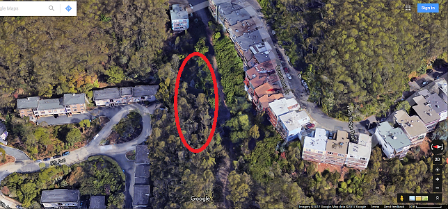


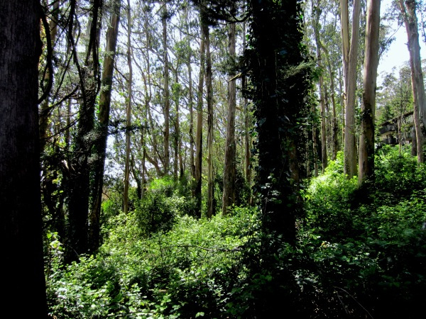
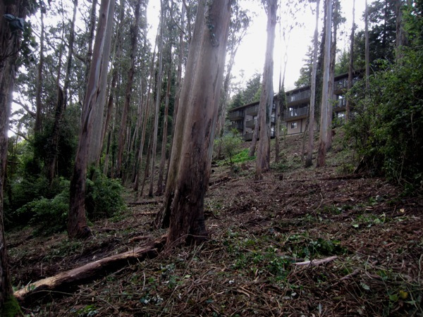
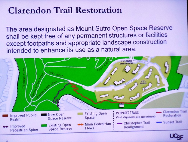
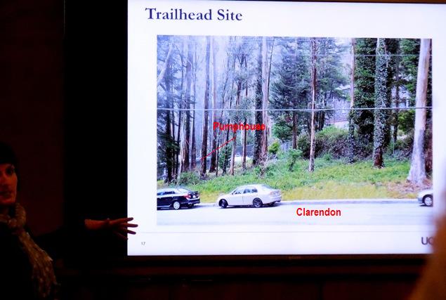
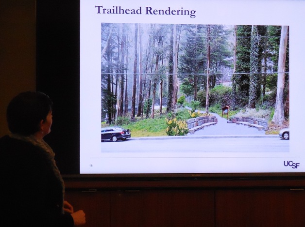
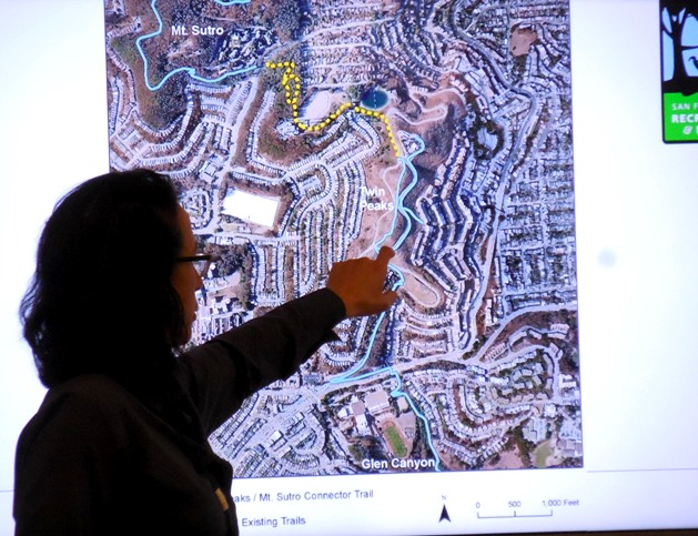
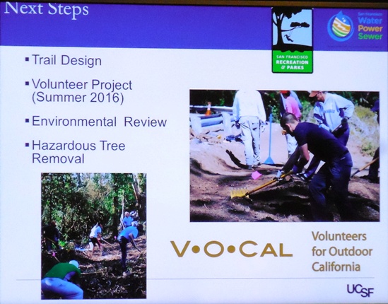
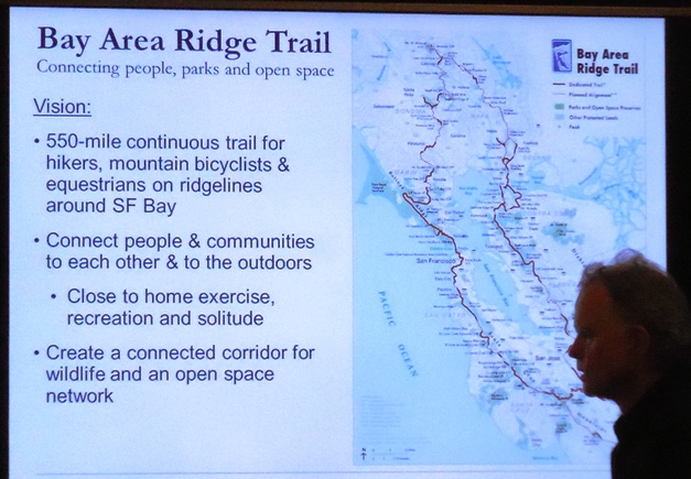
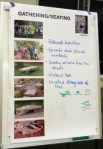
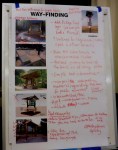
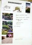


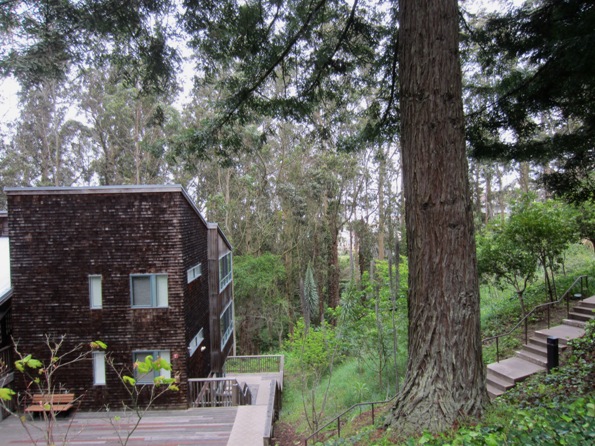
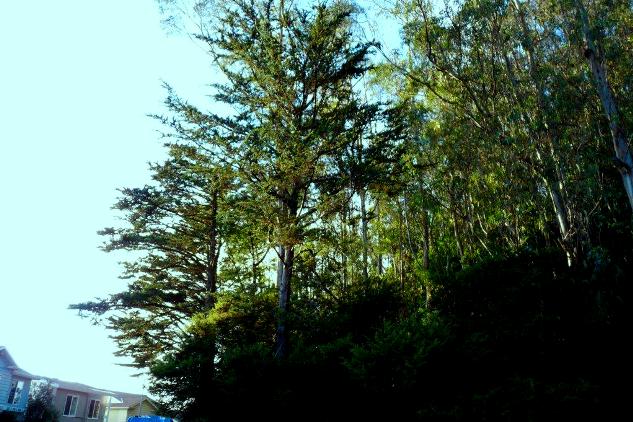


 Your participation has made a difference!