Sometimes, we need to leave our cars outside for convenience. If you’re doing that – bring your garage door opener inside. Thieves are breaking into cars, and snagging openers. As someone pointed out, a thief, can check the car’s registration papers to get the probable address. And then they’re into the garage and maybe the house.
I thought our neighborhood was pretty safe, but it happened on Devonshire yesterday. Here’s what a neighbor posted on our Yahoo Group:
Our car was unlocked last night, mistakenly, and someone opened it, got the garage remote and opened our garage door during the night. Apparently nothing was stolen except for the remote, but it’s scary and creepy. The same thing happened a few weeks ago, when the car was parked on a different street, and the remote was found a block away.
Let’s all keep a neighborhood watch –
PLEASE REPORT SUSPICIOUS PEOPLE and ACTIONS TO POLICE Non-Emergency Situations – 415-553-0123
Lock your house and your cars.
Keep the holidays safe and happy.
Thanks to the original poster for the heads up and the warning.
Just over on the other side of the hill, someone was getting a house renovated. They were lifting the whole house to strengthen the foundations so they could build higher. On Monday night, it collapsed and slid 50 feet downhill.
According to the SF Chronicle news report, the owner had wanted to demolish the dilapidated 1400-square foot rental and build a 4200-square foot house instead. He couldn’t get Planning Commission permission for that since it would reduce rental housing stock; instead he went with a major “remodel.” Neighbors fought the plan for 6 years, saying the larger house would be out of keeping with the neighborhood. But in the end, the Planning Commission approved it 5-2.
Looks like the house is totaled and the owner (Port Commissioner Melvin Murphy) will need to demolish and rebuild after all!
The good news: No one was hurt. Although another building apparently had to be evacuated, I think it was found to be safe and everyone was let back in. When I went by to take this photograph, they were allowing traffic through on Graystone Terrace, the narrow winding road below the structure.
It did make me think, though, about building on steep hillsides, and collateral risk. Hope whoever finally builds San Francisco Overlook is a lot more careful.
I’ve written here about neighbor Beverly Mack’s long battle to get traffic calming on Warren Drive. Then, finally, there were emails from SFMTA that they had approved two speed humps for Oak Park Drive, and two speed cushions for Warren Drive. Recently, someone let me know they’d actually been installed. And here they are. (Thanks, Beverly! It’s taken 5 years, but it’s done!)
OAK PARK DRIVE
Oak Park has two speed humps – like a gentle speed bump, on the stretch of road below the hillside. I drove over them, and I found them quite benign, they didn’t jerk my car.
WARREN DRIVE
Warren has speed cushions – like speed bumps, but with gaps so that a bus (or fire-truck) can avoid going over it.
While I was taking pictures, the 36 Teresita bus came by.
It needs to cross the double-yellow line to get past the speed cushion without going over it, but seemed to have no problem navigating it.
On the other hand, while I was waiting on Oak Park to turn left onto Warren, a car came by pretty fast on Warren Drive – from the direction on the speed cushions. So I think they’re a good thing, but maybe they haven’t slowed things down all that much. I’d still be careful on Warren.
I’d gone for a walk toward Tank Hill, the other evening, when I saw a shape scurrying across the road. Raccoon! And sure enough, it was Garbage Night, and there was the overturned trashcan. As I approached, I made out its tail, sticking out of the trashcan, and then, as it heard me, it came out and tried to decide whether to stay or run.
The light was poor, and the picture worse, but here you are. (It scampered off before I could get anything better.)
I’ve been wondering what’s happened – raccoons never used to up-end trashcans like this. They’ve been on a learning curve, it seems. Apparently, that’s what urban wild-life does – it becomes smarter. Here’s an article from Wired Science: How City Living Is Reshaping the Brains and Behavior of Urban Animals
Article from Wired Science: How City Living is Changing Animals’ Brains
THREE TRASHCAN SOLUTIONS
Meanwhile, our latest solution seems to be holding up – two crossed bungees, snagged outside the lid hinges on one side, and on either side of the main lip of the trashcan lid on the other. Like in this picture.
Walking around the neighborhood on garbage nights, we’ve seen other solutions.
One neighbor drilled a hole in the lid, and attached a strap with a bolt and washer. They then snagged the strap to the bar below.
But the solution that looked simple and ingenious was the one that tied up the trashcans with a bow, like shoe-laces in a larger size. Because it’s rope, not bungee, it doesn’t stretch, so presumably it’s difficult for the raccoons to pry off.
I got an email from Dan Provence of SFMTA. The measures – speed humps on Oak Park Drive, and speed cushions on Warren Drive – were approved. This is from the e-mail:
Thank you for all of the input regarding the proposed speed humps on Oak Park and the proposed speed cushions on Warren. The ballot results found that 89% of responding households were in favor of speed humps on Oak Park and 67% of responding households were in favor of speed cushions on Warren. We also received 6 emails in favor of the proposals and 3 emails against. These were presented to the public hearing officer prior to the hearing for consideration. At the hearing were several residents in favor of the proposals and none opposed. All of the measures were approved.
We will work with the Department of Public Works to schedule construction and we will be in touch with more details soon. Please let me know if you have any questions.
Dan Provence, Livable Streets Subdivision
He’s at:
SFMTA | Municipal Transportation Agency , Sustainable Streets Division
1 South Van Ness Ave, 7th floor
San Francisco, CA 94103
Phone: 415.701.4448
Fax: 415.701.4343
email: Dan.Provence@sfmta.com
(Note: The photo is of a 2011 accident on Devonshire, but it’s the kind of thing we fear could happen elsewhere.)
Readers of this blog may remember that neighbor Beverly Mack has been working since 2008 to get some traffic calming for Warren Drive and Oak Park. If you’d like to read about that, the details are in my September 2012 post: Traffic Calming on Warren Drive: When?
Well, we have Action! SFMTA will be sending round letters and ballots to us all with a proposal for traffic calming. I’m not sure what it will be (Beverly asked for speed bumps).
But – when you get the letter and ballot, please respond! You could be saving lives.
Here’s what SFMTA wrote to Beverly:
From: “Provence, Dan” <Dan.Provence@sfmta.com>
To: “Beverly Mack (bmack4paws@sbcglobal.net)” <bmack4paws@sbcglobal.net>
Sent: Friday, June 28, 2013 3:17 PM
Subject: Traffic Calming on Warren and Oak Park
Hi Beverly,
I wanted to let you know that soon you and your neighbors will be receiving letters and ballots regarding traffic calming on your street. The proposal included in the letter has been approved by various City departments and now it is up to residents to decide whether or not they would like to proceed with traffic calming measures. I will be out of the office next week but I will be available beginning July 8 to answer any questions.
Thanks,
Dan
Dan Provence
Livable Streets Subdivision
SFMTA | Municipal Transportation Agency
Sustainable Streets Division
1 South Van Ness Ave, 7th floor
San Francisco, CA 94103
Phone: 415.701.4448
Fax: 415.701.4343
email: Dan.Provence@sfmta.com
The San Francisco Forest Alliance and Save Sutro Forest are holding a meeting on 21 April 2013 to talk about the planned felling of trees on Mount Sutro — and on Mount Davidson. These actions would gut two important urban forests near our neighborhood and irretrievably alter the landscape.
Do you want to know:
How many thousand trees do they plan to cut down on Mount Sutro? On Mount Davidson?
Who’s “They”?
What about Pesticide use?
When will this happen?
For answers to these questions and more…
Come to the San Francisco Forest Alliance meeting.
WHERE: Miraloma Park Clubhouse, 350 O’Shaughnessy Blvd,
San Francisco, CA 94127
(It’s about 2 miles from Forest Knolls.)
WHEN: April 21st, 2013 (Sunday) – 4.30 p.m. to 6.30 p.m.
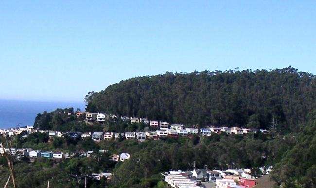
The Westside Observer had a detailed article about the planned San Francisco Overlook project. This is the 34-unit development planned for the end of Crestmont, a long winding road that has no other exit. (Click on the picture below to go to the Westside Observer website.)
I’ve been following the story for some years now, but it seemed like it was mainly being watched by a bunch of blogs. Now there’s a detailed story out there.
The steep hillside above the planned development
Of course, our neighborhood doesn’t need to read about the potential downsides of a large development in this location. We can see for ourselves. Just a quick walk through the area shows the risks: steep and unstable terrain; narrow roads where it’s a real possibility that emergency vehicles can’t get through; more traffic on a road where people walk and children play.
The hearing at City Hall is today, 7 March 2013, starting at 12 noon. Crestmont Preservation is calling on neighbors to turn out and make their presence felt. All the details are HERE.
This is being posted at the request of the Crestmont Preservation Organization. They support “Alternative B” that would result in 16 single-family homes rather than 34 units, with less traffic and safety impacts.
——————————
The steep hillside above the planned development
The important PLANNING COMMISSION HEARING on the San Francisco Overlook Development will be held THURSDAY, MARCH 7 [2013]. The session starts at noon at City Hall.
This is our opportunity to let the Planning Commissioners hear our community’s opposition to this ill-conceived project which threatens to overwhelm our neighborhood with its size, density and increased traffic in a hazardous hillside location which may threaten our homes both above and below the site. The hazards of much increased traffic on a dangerously narrow and winding street and the streets of Forest Knolls, especially at night and in foggy conditions, have not been experienced by the Commissioners or planners, most of whom have not visited the site to our knowledge.
COME TO THE HEARING AND LET THE COMMISSIONERS SEE BY OUR NUMBERS AND HEAR FROM THOSE OF US WHO WISH TO SPEAK HOW STRONG OUR OPPOSITION IS!
IN ADDITION, we encourage you to write or call our new District 7 Supervisor, NORMAN YEE (copy Commissioners, see contact list below). We, as his constituents, are hoping that he will stand up for our community to preserve its special character, ensure its safety and limit the volume of traffic that would be added if the project moves forwarding its currently proposed size. APPEAL to Supervisor Yee to support a smaller development (Alternative B in the EIR with 16 single family homes) which would markedly cut down on the traffic volume and safety risks.
Posting a recent email to the Planning Commissioners from an affected Forest Knolls Neighbor:
As the owner/occupant of (a Forest Knolls residence), I am directly affected by the proposed Crestmont development which includes 34 units of medium density housing.
I request that the Planning Commission refuse to certify the Final EIR for this project.
I request that the Planning Commission DENY the applicant’s request for a conditional use permit.
I am unalterably opposed to this project because:
1) The density of this proposed Crestmont Development is totally out of scale with the neighborhood.
2) The proposed 34 unit development will degrade the quality of life in the surrounding neighborhood by increasing traffic, overloading the available street parking, and increasing emergency service response time, particularly to the end of Crestmont Dr.
3) The proposed 34 Unit development lies within the Northwest Mt. Sutro Slope Protection Area. The hillside adjacent to the proposed project has already had several landslides. The proposed project is both a landslide hazard and an earthquake slide hazard. The underlying soil cannot be reinforced sufficiently to prevent the project from sliding down the hill during an earthquake, particularly if the underlying soil is infiltrated by water to any degree.
4) The zoning for the subject parcel is erroneous. The subject parcels should be rezoned to conform with the lower density zoning of the immediate neighborhood.
5) The Environmental Impact Report that has been prepared is fatally flawed because the emergency service vehicle access test that was run by the SFFD was run during the day during the week when there were few if any vehicles parked on Crestmont.
6) I submit that it is impossible for a fire engine or an ambulance to negotiate Crestmont Dr. at any reasonable speed when there are numerous vehicles parked on both sides of the street. Any victims in need of emergency services at the end of Crestmont Dr. will be dead before emergency service vehicles can reach them.
7) I contend that Crestmont is too narrow to allow a fire truck or other emergency vehicle to pass even one car travelling in the opposite direction.
8) I submit that elimination of street parking on either side of the street would exacerbate the existing parking shortage.
9) I request that the emergency service vehicle access test be redone on a Sunday evening at 10 PM when there are numerous vehicles parked on Crestmont.
I contend that the inaccessibility of the Crestmont Development site is good cause to down zone the subject parcels to conform with the low density zoning of the immediate neighborhood thereby restricting occupancy to a maximum of 10-14 units.
As the developer paid less than $100,000 per lot, he will still be able to make millions of dollars even if he only constructs ten single family homes instead of the 34 units he is proposing.
SUPERVISOR NORMAN YEE
City Hall
1 Dr. Carlton B. Goodlett Place, Room 244
San Francisco, CA 94102-4689
(415) 554-6516 – voice
(415) 554-6546 – fax
Norman.Yee@sfgov.org
Contact list for Planning Commissioners
RODNEY FONG
Commission President
San Francisco Planning Department
1650 Mission Street, Suite 400
San Francisco, CA 94103-2414
(415) 202-0436
planning@rodneyfong.com
CINDY WU
Commission Vice-President
1650 Mission Street, Suite 400
San Francisco, CA 94103-2414
cwu.planning@gmail.com
MICHAEL J. ANTONINI
Commissioner
2827 Franklin Street
San Francisco, CA 94123-3107
PH: (415) 558-6615 ext.2
FX: (415) 558-6409
wordweaver21@aol.com
GWYNETH BORDEN
Commissioner
San Francisco Planning Department
1650 Mission Street, Suite 400
San Francisco, CA 94103
PH: (415) 367-3801
plangsf@gmail.com
RICH HILLIS
Commissioner
San Francisco Planning Department
1650 Mission Street, Suite 400
San Francisco, CA 94103-2414
richhillissf@yahoo.com
KATHRIN MOORE
Commissioner
San Francisco Planning Department
1650 Mission Street, Suit 400
San Francisco, CA 94103
PH: (415) 558-6615 ext.5
mooreurban@aol.com
HISASHI SUGAYA
Commissioner
San Francisco Planning Department
1650 Mission Street, Suite 400
San Francisco, CA 94103-2414
PH: (415) 558-6615 ext.7
FX: (415) 558-6409
hs.commish@yahoo.com
REMINDER: Please display the poster in your window and urge your neighbors to also display the poster! If you need a poster, please email info@crestmontpreservation.org.
I guess by now, most people in Forest Knolls have some idea that big changes are planned for the forest behind our neighborhood. Essentially, UCSF plans to cut down over 90% of the trees on three-fourths of the forest, and remove 90% of the undergrowth. The only bit to be spared would be 15 acres or so of steep hillside on the western side, above Inner Sunset.
UCSF is having a hearing on Feb 25th at 7 p.m. (They sent around postcards about this.) It’s at the Milberry Union, 500 Parnassus, CA 94134. If you can attend, please do, and speak up. If there’s a big turnout, they may limit each speaker to 2-3 minutes, so have your points ready.
WHY WE’RE CONCERNED
We’re concerned that it would ruin the forest’s character, and Forest Knolls would face consequences like:
Changes in wind patterns (the tall, closely-spaced trees are an impressive windbreak);
Risk of landslides (the old forest has intertwined and intergrafted roots that function like a living geo-textile and hold up the mountain, while the exposed rock on Twin Peaks has a rock-slide every year or two);
Pesticide drift into our neighborhood, affecting us and our pets (right now, Sutro Forest may be the only pesticide-free wildland in the city; the Natural Areas Program, which controls most of it, uses pesticides regularly)
Increased noise (the vegetation – the leaves of the trees and the shrubs in the understory are like soft fabrics absorbing sound)
Changes in air quality (trees reduce pollution by trapping particle on their leaves until they’re washed down)
Environmental impact – (eucalyptus is the best tree species for sequestering carbon because it grows fast, large, is long-lived, and has dense wood; but felled and mulched trees release this carbon right back into the atmosphere).
The implementation would be in two phases; it would start with the “demonstration” plots, around 7.5 acres in Phase I. The largest of these, #1 in the map is a 3-acre strip directly above Forest Knolls. Most of the trees would be cut, and tarping or pesticides used to prevent resprouting. Later, UCSF would extend the same plan to the entire forest (except for the 15 acre piece mentioned).
WHAT ELSE YOU CAN DO:
1. Write to the Board of Regents, who will ultimately decide whether to approve this project. Ask them why they are undertaking this controversial, expensive, and ecologically destructive project, and gutting a San Francisco treasure to achieve a “parklike” environment. You can contact the Regents at their website HERE. (Their email address is: regentsoffice@ucop.edu )
2. Write a comment on the Draft Environmental Impact Report. The report is HERE. (It will take some time to load.) The person to write to is Diane Wong, and her email address is at: EIR@planning.ucsf.edu
The article below has been copied with some modifications from http://www.SaveSutro.com, which is a website set up to inform people about Mount Sutro Cloud Forest and to defend it.
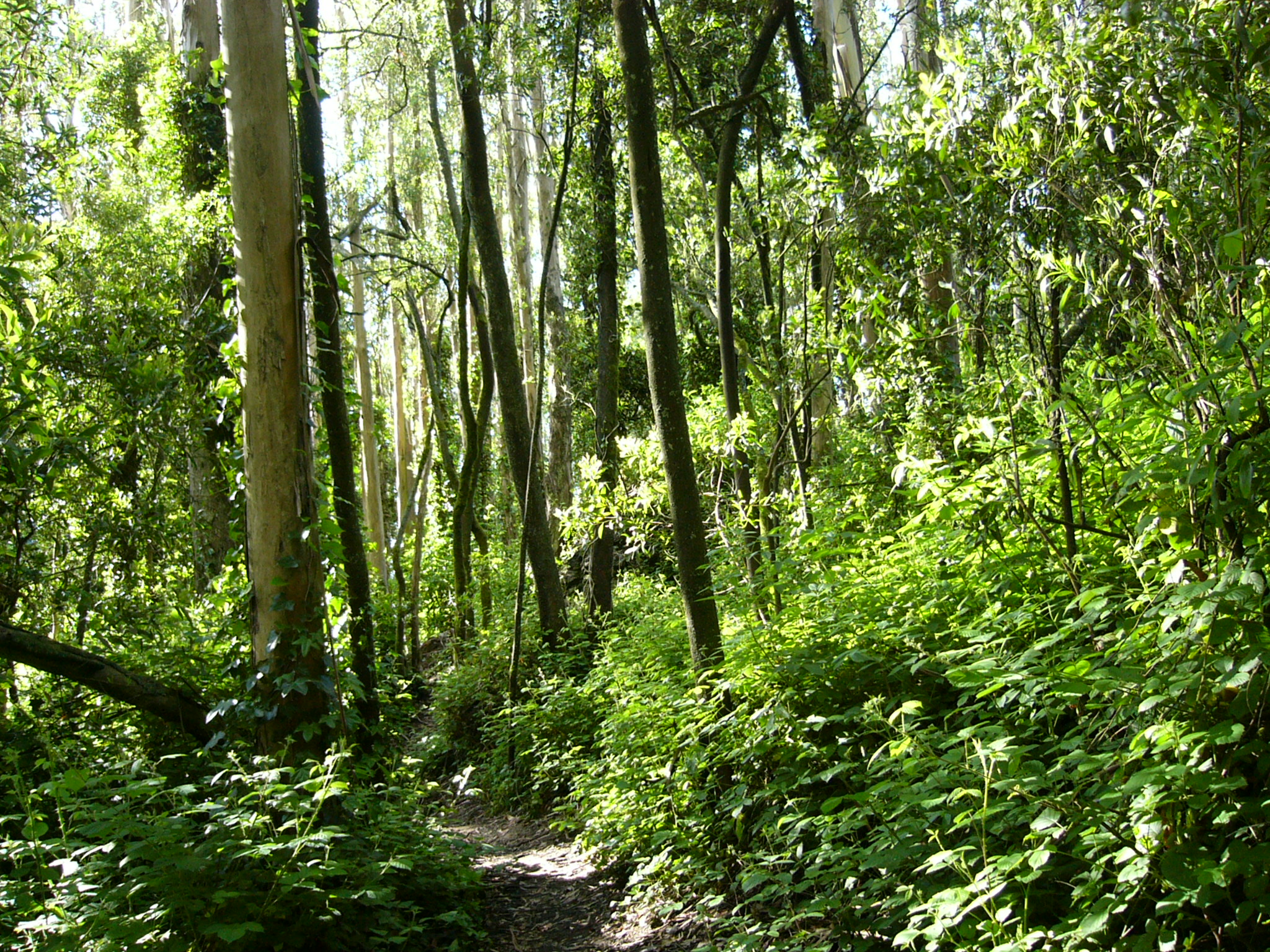
Mount Sutro Forest has approximately 45,000 trees in the 61 acres belonging to University of California, San Francisco (UCSF), and designated as an open space reserve. This dense forest, with an estimated 740 trees per acre, a sub-canopy of acacia, an understory of blackberry and nearly a hundred other plant species, is functionally a cloud forest. All summer long, it gets its moisture from the fog, and the dense greenery holds it in. Where it isn’t disturbed, it’s a lush beautiful forest, providing habitat for birds and animals, and a wonderful sense of seclusion from urban sounds and sights.
UCSF now has published a Draft Environmental Impact Report (DEIR) on a project to remove over 90% of the trees on three-quarters of the area. Only 15 acres – on the steep western edge of the forest – will remain as they are. Tree-felling could start as early as Fall 2013.
Comments were due on March 4th, but because of the length and complexity of the document, neighbors asked for, and got, an extension. Comments are now due before March 19, 2013.]
On most of the forest (44 acres), UCSF plans to cut down trees to achieve a spacing of 30 feet between trees – the width of a small road – and mow down nearly all the understory habitat. On another 2 acres, they will space the trees 60 feet apart. The stumps of the trees will be covered in black plastic, or else poisoned with Garlon to prevent re-sprouting. Eventually, this will kill the roots, which will start to decay. We’ll address some of these issues in more detail in later posts.
Right now, we want to talk about the number of trees that will be felled. A spacing of 30 feet between trees gives about 50-60 trees per acre. A spacing of 60 feet gives 12-15 trees per acre.
(The easiest way to think about it is that each tree occupies a 30 x 30 foot space, or 900 sq ft. An acre is 43,560 sq ft, so this would give 48.4 trees to an acre. The DEIR calculates it as 61 trees per acre, assuming each tree occupies a circle that’s 30 feet in diameter, 707 sq ft. But there’s no way to arrange circles without wasted spaces between them, so this doesn’t exactly work.)
So on 44 acres, they will retain maybe 50 trees per acre (or maybe fewer). On two more acres with a 60-ft spacing, they will retain 12-15 trees per acre. All the rest will be cut down. Even using the DEIR’s overly optimistic calculation, they will be felling some 31,000 trees. Our calculations are closer to 32,000. Either way, it’s a huge number.
That means that in the 46 acres where UCSF will be felling trees, they will remove more than 90% of the standing trees.
The DEIR says that they will start by cutting down trees that are dead or dying. Aside from their value as habitat (some birds like woodpeckers depend on them), there are not all that many of them in Sutro Forest, which despite everything that has been claimed to to opposite, is a thriving forest. Next in line will be trees with diameters under 12 inches, or roughly 3 feet around – as thick as an adult’s waist. Then they’ll start on the larger trees. Since it’s going to be 90% of the trees, we expect thousands of large trees to be removed.
IT GETS WORSE
However, this is not all. We expect further tree losses for four reasons:
Wind throw. Since these trees have grown up in a dense forest where they shelter each other, removing 90% of the trees exposes the remaining 10% to winds to which they’re not adapted. This can be expected to knock down a significant number of the trees not felled. Since the Plan only calls for monitoring the trees and felling any that seem vulnerable to wind-throw, it’s unlikely any vulnerable trees will be saved.
Physical damage. Damage done to the remaining trees in the process of removing the ones they intend to fell. With such large-scale felling, damage to the other trees is inevitable, from machinery, erosion, and falling timbers.
Pesticide damage. This forest has an intertwined, intergrafted root system. When pesticides are used to prevent resprouting on tree-stumps and cut shrubs and ivy, it is quite possible for it to enter the root system and damage remaining trees.
Loss of support. Compounding the effects of the wind-throw, the remaining trees will suffer from a lack of support as the root network dies with 90% of the trees being removed. This could destabilize them, and make them more likely to fail.
What remains will be a seriously weakened forest with a greater risk of failure and tree-loss, not the healthier forest that the DEIR claims. It is likely that the long-term impact of the Project will be the elimination of the forest altogether, and instead will be something like Tank Hill or Twin Peaks plus a few trees.
IMPLEMENTING THIS PLAN
The project is to be implemented in two phases. In the first phase, trees will be felled and the understory removed in four “demonstration areas” totaling 7.5 acres. They are shown on the map below in yellow, as areas #1-#4. [The 3-acre area #1 is right above Forest Knolls.] One of these, #4 “East Bowl”, is the two-acre area slated to have only 12-15 trees per acre.
One area (#5 on the map) is supposed to be a “hands off” area to demonstrate the untouched forest. However, a trail has already been punched through it in November 2011, even before the DEIR had been published.
During this phase, they would experiment with the 3 acres on the South Ridge, just above the Forest Knolls neighborhood. On 1 acre, they would use tarping to prevent regrowth of felled trees; on 1 acre, they would use pesticides, particularly Garlon; and 1 acre they would trim off sprouts by hand. They could also use pesticides on the understory “consistent with city standards” – presumably those of the Natural Areas Program (See article on NAP’s Pesticide Use.)
In the Second Phase, the plan would be extended to the remaining forest, with the proviso that not more than a quarter of the forest would be “thinned” at “any given time.”
Why it’s called “Forest” Knolls – and described as “Marin-like”Digitally-altered image – Forest Knolls without Sutro Forest. Maybe there’ll still be some trees left after this Plan is implemented.
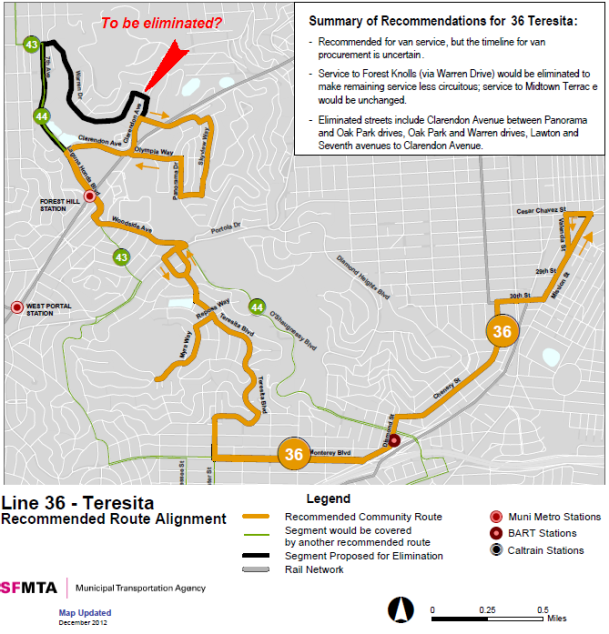
This article about the proposed curtailment of the 36 Teresita bus service was written by Joe Humphreys for the Midtown Terrace website. It is re-published here with permission and added emphasis. (Thanks, Joe!) The map of proposed changes that we published here recently is appended for ready reference.
The San Francisco Planning Department and the San Francisco Municipal Transit Agency have issued an “Initial Study” for the “Transit Effectiveness Project”. The study is, apparently, the first step towards numerous changes in San Francisco’s public transit system. Most of this 381-page document is consumed with arguments as to why the many changes will result in “improvements” to that system. Somewhat buried in that document and its two appendixes, however, are recommended changes to the 36 Teresita service that provides public transportation to the residents of Midtown Terrace and Forest Knolls.
The changes are generally similar to changes that were proposed and defeated a couple of years ago. They eliminate part of the existing route and would use vans instead of Muni buses to provide service on the remaining route. Under the previous proposal, service would have been eliminated on some of the steeper streets of Midtown Terrace and in all of Forest Knolls. The current proposal would not make route changes in Midtown Terrace but would eliminate service in Forest Knolls. (Perhaps, the planners feel it would be easier to pick off one community at a time.)
The proposed change from bus to van service does not give any indication of the nature of the vans but simply says “Recommended for van service, but the timeline for van procurement is uncertain.” It also does not say whether or not the van service would run at the same frequency as the existing service.
The Midtown Terrace and Forest Knolls communities already suffered a degradation of bus service in the last round of changes when the frequency during the day was reduced from 20 minutes to a half hour. The areas served by this bus are very steep and further curtailment of service would work a hardship on residents who depend on this line and a particular hardship on the increasing numbers of elderly residents who have limited or no ability to drive. (And, for all residents it goes against the general public policy of encouraging use of public transit as an alternative to driving.)
The substitution of van service for bus service requires careful study. Many older residents use the bus for shopping. Would vans accommodate their shopping bags as well as the buses do? The 36 is also used as transportation to the Glen Park Bart station which provides service t0 the San Francisco and Oakland Airports. Would the proposed vans provide reasonable space for a suitcase? Would vans be of sufficient size to accommodate all of those in these neighborhoods who use the service during commute hours to connect with other routes?
The SFMTA “Initial Study” is apparently a lead up to the development of an environmental impact report. Comments on the proposals and issues that should be considered in that report can be made by writing to
San Francisco Planning Department
Attention: TEP
1650 Mission Street, Suite 400
San Francisco, CA 94103
or email to debra.dwyer@sfgov.org
URGENT: The period for making comments closes on February 22, 2013
Someone drew my attention to the new SF MTA study released January 23rd. Though the 36 Teresita bus (the only one that comes through our neighborhood) is not mentioned in the actual report, it shows up in the maps. It looks like the plan is to discontinue service to Forest Knolls, and maybe at some point replace it with a van service. The map below is taken from that report. (The whole report is available as a PDF HERE.)
Too large!!! Not safe!!! Help Stop or Downscale!!!
Working to Stop or Downscale S.F. Overlook Development
Update February 8, 2013
CRITICAL PHASE!!! NEIGHBORS UNITE!!!
The Planning Commission Hearing is scheduled for Thursday, March 7 and it’s time to mobilize! Any further development on this hillside, at the end of the City’s longest cul-de-sac, is fraught with risk and is wrong for our neighborhood. But if construction proves to be inevitable, instead of the proposed 34 unit development, our goal is to get this project downscaled to a smaller number of single family homes as proposed in Alternative B in the EIR (p. 274).
Please mark your calendars and plan to attend two important neighborhood meetings as well as the critical Planning Commission hearing.
Wednesday, February 13 at 7 PM – S.F. Overlook Developer Forum. Location: Midtown Terrace Community Room, 280 Olympia Way (at Clarendon Ave.) Hear the developer’s proposals and express your concerns.
Tuesday, February 19, 7-9 PM – All Forest Knolls and Crestmont neighbors are invited to a get-together to discuss issues and strategy for the Planning Commission Hearing. Hosted by Reed Minuth and Megin Scully, 485 Crestmont Drive. RSVP Jeffrey Eade, eadej@me.com, 415-606-4414.
Thursday, March 7, 12 Noon – Planning Commission Hearing, Room 400, City Hall. Everyone opposed to this project is urged to attend the hearing! Those who wish to speak will have 3 minutes to present their arguments against this massive 34 unit development which threatens our neighborhood. ATTENDANCE IS IMPORTANT! Additional information and flyer posted on http://crestmontpreservation.org
REMINDER: Please display the poster in your window and urge your neighbors to also display the poster! If you need a poster, please email info@crestmontpreservation.org.
Some time back, I’d written about PG&E impersonators wandering around and trying to get access to homes in Glen Park. At the time, no crimes had been committed (and apparently, impersonating a PG&E inspector is not a crime).
Yesterday, there was a burglary/theft from a building on Nebraska at Cortland. A subject, posing as a PG&E employee, entered a home to “check the meter”. He let himself out when he was done and the resident’s laptop computer was missing. Per PG&E, the meters in the area of the theft digitally upload which eliminates the need for home visits. Please post this information on Bernalwood Blog and remind residents that if they are not expecting an employee from a utility company, don’t let them in without first calling the utility company to verify that an employee is in the area. Also, they don’t have to open the door, they can speak through the door. If someone tries to enter their home “checking meters” and leaves while the resident is calling PG&E, they should call the police.
Thanks,
Captain Tim Falvey
We haven’t had any reports like this in our neighborhood, but it probably makes sense to be reasonably cautious.
Mr Gary Testa, owner of the San Francisco Overlook project (earlier the Crestmont Hills development) is inviting neighbors and stakeholders to a meeting on February 13, at Midtown Terrace Community Room on Clarendon to discuss the proposed development. Since our Forest Knolls communities are directly impacted, I think it’s important for us to know about this, and attend if possible. (I’ve written about it earlier, HERE.)
Here’s his letter.
January 30, 2013
Dear Neighbors,
I am pleased to invite you to join me for an update on my proposed project, San Francisco Overlook, and for a brainstorming session regarding new ideas to make improvements to the neighborhood as a whole. I hope by now that most of you are aware of the project I’ve proposed for my lot at the end of Crestmont Drive. If you are unfamiliar with the details and would like to learn more, I invite you visit my project website at http://www.sfoverlook.com.
Over the last two years I’ve hosted a number of presentations and meetings discuss my proposal, solicit feedback and hear suggestions of ways to make my project better. Some requests are simply not possible to accommodate, such as building only 1/3 of the proposed homes (the proposed project already proposes a density significantly below what is permitted by code) or providing access from a street other than Crestmont (via land which I do not own), but I’m happy to say that my project is responsive to many key concerns such as hillside stability and fire suppression. In addition, I have specifically incorporated the request for more parking as part of my proposal. My proposal currently includes two parking spaces per unit, a 33 increase over the typical maximum ratio of 1.5 spaces per unit.
Your recommendations and suggestions have helped to improve my project and I appreciate your participation. However, I am aware that I still face opposition from some in the neighborhood and have been advised that the MSWOA board has hired an attorney to explore taking legal action against my project. Regardless of your opinion of the project, the fact is that a protracted legal battle will require significant financial assessments of all property owners within our owners’ association. [Webmaster: This refers to the Mount Sutro Woods Owners Association.] In light of the substantial potential costs to all members, I feel it is best to broaden this discussion to include all stakeholders.
My position is simple – I believe my money would be better spent for the benefit of the community rather than used to enrich attorneys. I also don’t believe that every homeowner should be required to pay for a legal action which he or she may not support or from which they may gain no real benefit. I’ve already invested a considerable sum in my project to date, and I’m prepared to spend whatever amount is necessary to defend my project and property rights should legal action be forced upon me, but I would of course prefer to avoid what I consider a waste of money and instead work with my neighbors to redirect such resources towards meaningful improvements to benefit the entire neighborhood. For example, pedestrian-scale street lighting could enhance property values and help keep cars from being burglarized and/or improvements to the existing common areas could enhance beauty and create usable areas to walk dogs and for children to play. These are only a few initial ideas; there may very well be other ore important priorities that we haven’t yet considered which is why I’m once again seeking your input with this invitation.
In the spirit of collaboration I recently reached out to the MSWOA board and began discussions about whether a community partnership of the kind I’m describing is possible. I’d like to now broaden this discussion and invite all my neighbors to participate in a brainstorming session about other general or specific contributions we could make. If you are a homeowner whose home is inhabited by renters and you feel it is appropriate to include your tenants in this discussion, please feel free to pass on this invitation to them.
Please join me:
Wednesday, February 13th at 7:00 PM
Midtown Terrace Community Room
280 Olympia Way (at Clarendon Ave.)
I hope to see you there, but if you cannot attend I still would like to get your thoughts and input. Please email me at info@sfoverlook.com or please feel free to call my outreach director, Jessica Berg, at 415-385-4876.
As usual, there was nothing much from Forest Knolls or Midtown Terrace in the Park Station police newsletters. (We like it that way!)
But a few things did catch my eye:
January 23, 1.49 a.m. Drunk driving at Clarendon and Oak Park. “Sergeant Callaway & Lewis located a vehicle that had been involved in a hit & run traffic collision. The driver was determined to be seriously in the bag.”
Jan 17th, 1.55 a.m. A report of an attempted “hot prowl” at 300 Warren Drive: “Victim was awoken by noise at his rear door. He looked out and saw the suspect trying to break in. Victim yelled at the suspect who fled.” (A “hot prowl” is when someone enters a home when people are present.)
Jan 17th, 12.30 p.m. Malicious damage to a vehicle at Clarendon and Panorama.
Jan 17th, 11.15 a.m. A collision at Clarendon and Christopher, because someone was going too fast.
Jan 5th, 9 a.m. 100 Marview. A car was stolen.
Jan 3rd, 11.30 p.m.Collision at Crestmont and Devonshire – someone was speeding.
POISONED TREES UPDATE
Those poisoned trees, which I wrote about HERE? I’d written to UCSF about them; they said it looked like it was SFWD’s business. A few days ago, I saw SFWD working there, and now it looks like they have cut down one of the trees and trimmed the other. I suppose there was no other way with the trees becoming unsafe.
I got this message for inclusion on the blog: There’s a meeting on Jan 30th, 2013.
Join Lt. Erica Arteseros and the Neighborhood Emergency Response Team (NERT) partner with SF City Administrators office, Patrick Otelinni, Director of Earthquake Safety, to look at seismic safety of SF buildings.
Learn the most current information on the Citizens Action Plan for Seismic Safety program (CAPSS) including an introduction of the proposed Pilot Program of ‘Soft Story’ Projects to implement seismic upgrade in those most vulnerable of residential/small commercial buildings and how neighborhood community preparedness plays an integral role in our ability to remain resilient before and after a major earthquake.
Open to the public – bring a friend
Agenda:
NERT – An overview – Simple solutions
CAPSS – What it is – Advantages & Benefits – How to get involved
Q & A – Future Next Steps
Date: Wednesday, January 30th, 2013
Place: County Fair Building (formerly the Hall of Flowers) -Bring a family, friends, neighbors
(Street parking available – towing on the north side of Lincoln Way – Muni info: http://www.nextmuni.com)
Refreshments, Displays, Handouts, will be available.
Presenters will include:
Lt. Erica Arteseros, NERT Program Coordinator
Lt. Erica Arteseros has been the Program Coordinator for the SF Fire Department’s Neighborhood Emergency Response Team (NERT) since 2004. She supervises the training of people in NERT’s disaster preparedness and response classes and has expanded the advanced training classes offered to NERT graduates so volunteers can maintain skills. Lt. Arteseros has also worked extensively with City agencies, the private sector, and individual citizens in pre-disaster planning and training.
Reuben Hechanova, Architect
Appointed by Mayor Gavin Newsom in 2008 to the Building Inspection Commission (BIC) that oversees policy and administrative governance of SF Department of Building Inspection, Reuben served as the BIC President in 2010 where he helped move the CAPSS (Citizen Action Plan for Seismic Safety) forward stepping down from the BIC in March 2012.
Laurence Kornfield, Policy Development
Chief Building Inspector in SF for 20 years, Laurence has been active in earthquake hazard mitigation, response and recovery since the Loma Pieta earthquake in 1989. He initiated and oversaw SF’s recently completed Community Action Plan for Seismic Safety (CAPSS), and is currently developing long-term implementation plans for that CAPSS project. Mr. Kornfield is active in policy development related to building performance, disability access, sustainability, etc.
Patrick Otelinni, Director of Earthquake Safety -SF City Administrator’s office
Patrick is a certified building inspector, previously serving on the Mayor’s Soft Story Task Force. Patrick understands SF building issues, codes, permitting and construction. Patrick’s job is to implement a 30 year plan to reduce the city’s most dangerous risks in a future earthquake, including retrofitting, soft-story buildings, private schools, and some concrete building. He will guide the Earthquake Safety implementation plan (ESIP) while implementing the recommendations of CAPSS.
I attended a Community Action Group (CAG) meeting of UCSF last evening, mainly about their Long Range Development Plan (LRDP), 2014-2035. (It was a follow-up to the previous meetings, one of which is reported HERE.) This meeting covered three broad areas: The Space Ceiling; Parnassus Avenue Streetscape and traffic; and UCSF Shuttle bus operations. But first, an announcement, important for anyone following the Mount Sutro forest battle:
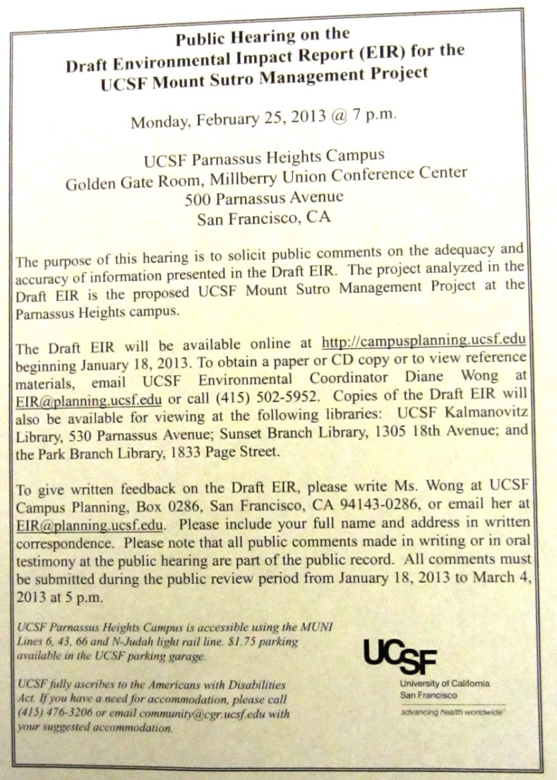
The Sutro Forest Draft Environmental Impact Report (DEIR) will be published on Jan 18th, 2013. Then UCSF will take comments for 45 days; respond to the comments; and then they plan to certify the EIR. There’s a meeting on February 25th, at 7 p.m. during which people can give comments and feedback. (Clicking on the thumbnail picture here will take you to a larger – and hopefully readable version of the notice.)
SPACE CEILING
In that last article, I noted that UCSF had set itself a 3.55 mn square foot “space ceiling” in response to neighborhood anger at their expansion strategies in the 1970s. However, it shot past this space ceiling early on, and currently exceeds it by 8.2%. For many neighbors – especially those in the Inner Sunset – space ceiling compliance is one of the most important issues. They hoped the new LRDP would bring UCSF into compliance.
No such luck. It looks like it will actually go to as high as 9% over the limit when the existing Moffat Hospital is demolished and rebuilt, perhaps 10-12 years from now.
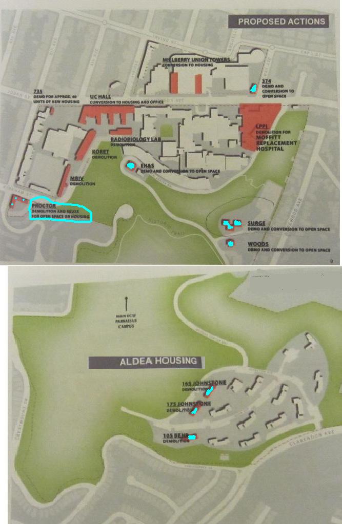
UC Hall, an old and historic building, was originally slated for removal. That would have reduced the excess over limit. But now they plan to convert it to a mix of housing and other uses. Since housing doesn’t come under the space ceiling, this helps – but it doesn’t actually reduce congestion and related concerns. Later, UCSF may convert UC Hall completely to student housing, thus taking it out of the calculation. They also plan a similar housing conversion for Milberry Union towers, which also will be gone from the numbers (though not from the campus).
Other minor reductions in the space ceiling will come from demolishing a bunch of small buildings, including several in the forest, and three blocks of student housing in Aldea campus. I’m finding this counter-intuitive. The main congestion impact is down in the Inner Sunset, so UCSF is demolishing buildings in the lightly-trafficked Sutro Forest, and adding housing along Parnassus?
Anyway, by a combination of housing conversions and minor demolitions, they expect to end 2035 at only 5% over the space ceiling, compared with 8.2% now. The map above shows the actual demolitions in turquoise; the pink buildings will either be demolished and rebuilt, or converted to housing. One building, Proctor, is undecided; it could be made Open Space, or converted to housing.
UCSF are also considering giving up their Laurel Heights space and co-locating those functions at Parnassus or Mission Bay (or both).
PEOPLE AND CROSSWALKS
The people numbers – which were originally supposed to be limited to 13,400 average daily population and then to 16,000 – is already at around 18,000. According to the forecast, it will rise to 18,500-18,900 in 2035. Members of the CAG were rather skeptical about this number.
In addition to construction and changes in use in the buildings along Parnassus, they plan to remodel the road itself to make it more pedestrian-friendly and give it a stronger sense of place. Better sidewalks and a huge cross-walk are in the plans. The tree plan involves removing some 60 trees that are hazardous or “poor quality” and planting around 70. They will also evaluate the redwood grove at Parnassus and 7th at some later date, if they haven’t removed it during their construction work first.
There was also a discussion of shuttle-bus operations, the upshot being that they may be better able to match demand (peak demand exceeds number of trips on some routes, but doesn’t match capacity on others) and supply.
The Glen Park blog reports a person who purports to be from PG&E has been going to homes and leaving service notices. The service notices appear to the be legitimate, but the phone numbers are crossed out and different ones given to call. They’ve informed the police, but nothing can be done unless the person actually commits a crime – and impersonating a PG&E repairman isn’t one. They’ve also called PG&E, which apparently has heard of a few such cases.
I haven’t heard of anything like this in our neighborhood, but I thought I’d let everyone know.
 Sometimes, we need to leave our cars outside for convenience. If you’re doing that – bring your garage door opener inside. Thieves are breaking into cars, and snagging openers. As someone pointed out, a thief, can check the car’s registration papers to get the probable address. And then they’re into the garage and maybe the house.


![Crestmont%20Poster-400w[1]](https://forestknolls.info/wp-content/uploads/2011/04/crestmont20poster-400w1.jpg)