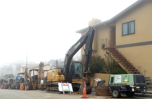
They’re replacing sewer pipes on Woodhaven, right here in Forest Knolls. If you’re an aficionado of big machines (or have kids who are!), there are plenty.
I took these photos over the last week.
Every day is different and fascinating.
This was today!
Here’s the notice about the Sewer Replacement Project. It’s 5-6 weeks, they said, and started Aug 6, 2018. The first of many, from the sound of it. The big machines may be coming to a street near you!
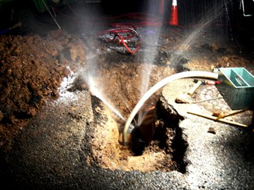
Of course, it’s a lot of noise and dust and access/ parking limitations for the homes on Woodhaven and nearby, but hopefully it will prevent plumbing problems in future. Like this broken water main from 2009. That wasn’t even a sewer line, which would be more insidious!
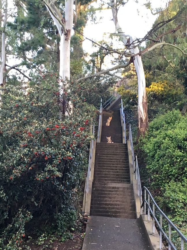
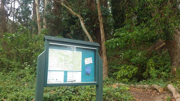
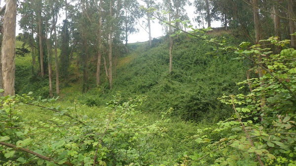
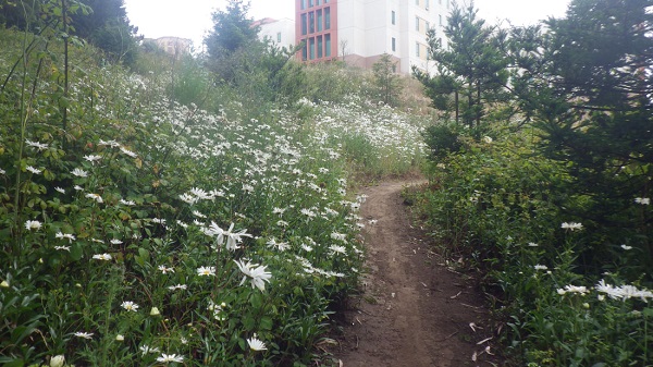
Recently, I saw a new trail marker/ map on Clarendon Avenue, across the street from “The Woods” townhome complex, and decided to explore.
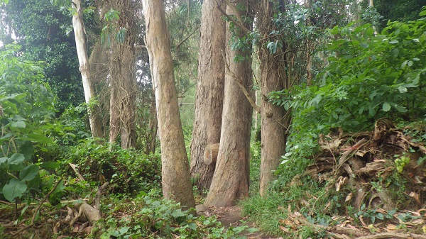
It goes through the ravine that probably was part of the lake in olden times. It’s now dry, and forested with eucalyptus and understoried with blackberry. Laguna Honda Hospital (LHH) gets it cleared out occasionally with goats. It’s quite delightful, a narrow winding trail that climbs up the other side of the ravine and comes out in LHH’s front yard.
Hiker and blogger Tony Holiday tried out the same hike – though he went a bit further, beyond the juvenile detention facility – and has given me permission to use his story and some pictures here. (For lots more great pictures, see his blog post, Daisies, on his site Stairways Are Heaven. It’s also a great resource for transit-friendly hikes.)
* * *
From DAISIES by Tony Holiday
Thanks again to a good Facebook friend who told me about a new multi-use trail. And it’s a beauty!
The trailhead is on the Midtown Terrace side of Clarendon, just past Laguna Honda Reservoir. This is the south side of Clarendon, across the street from “The Woods” residences. There’s a sign with a map at the trailhead. It’s also a short distance from Olympia Way and the Midtown Terrace Playground.
Does this trail have an official name? If not, how ‘bout the “Woods” Trail?
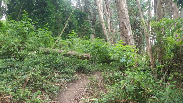
Loved it immediately. Lush, narrow, definitely magical, with beautiful old trees.
It curves round, winding up to a south ridge.
No one on the trail but me (and Karl the Fog).
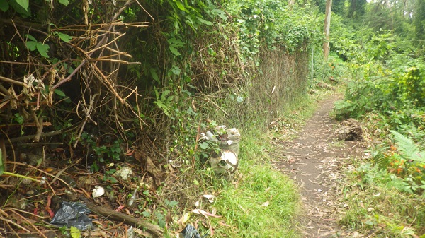
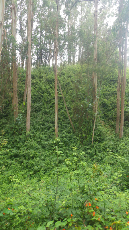
Nearer the summit was chainlink fencing and some old trash just off the trail. The cans, etc. will probably eventually be cleaned up. An old dumpsite for Laguna Honda Hospital?
To my left as I climbed were backs of Dellbrook Ave. homes. To my right, above, some of the many hospital buildings, old and new.
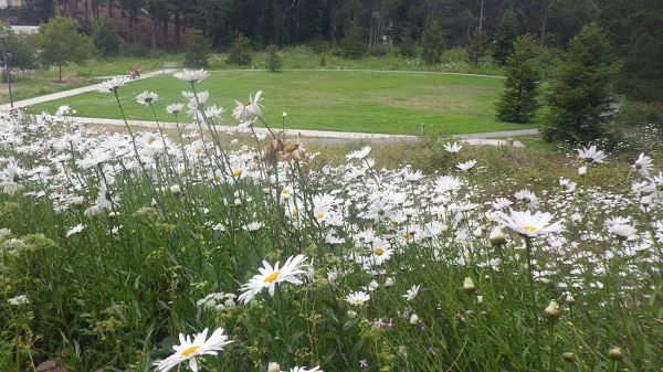
Then there were all these amazing white daisies along the trail.
There are benches just inside the hospital grounds behind one of the buildings. Still no one around but me. Continued up to a way out at a hospital parking lot.
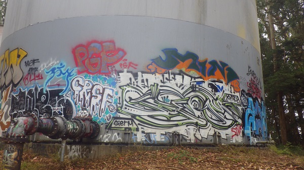
From here delighted to see more woods just ahead.
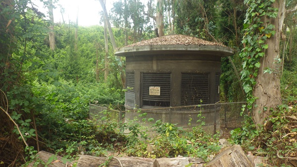
Hidden away in the forest here are two huge graffiti-covered tanks.
Started down (west) alongside the hospital grounds to my right; to the left the Juvenile Probation Dept. Down at street level was Woodside & Idora. Continued curving downhill to the #43 bus stop that’s just across from the Forest Hill Metro Station.
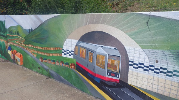
Another treat —the colorful mural at the entrance to the hospital grounds on Laguna Honda at the bus stop. I think this has to be my favorite of all murals seen so far. [For lots more mural photos, see Tony’s original blog post.]
As everyone probably knows by now, West Portal tunnel is closed while they repair and replace the hundred-year-old lines.
The main staging area is West Portal, the commercial street. It’s a big mess. But a big intriguing mess. (And, we hasten to add, it’s open for business and the shops and restaurants are operating normally.)
We were fascinated by the huge, specialized machines parked everywhere in the first couple of blocks of West Portal.
And here are some more:
All in matching, very visible yellow, though each machine is different.
It’s all very much under control, and as long as you avoid Ulloa and Vicente and the stretch between, it’s not difficult to drive there or find parking.
But the stores sure could do with some support, so if you were thinking about shopping or dining there… please do. And if you have kids who are interested in huge machines and construction activity – it’s the perfect time to ogle the earthmovers!
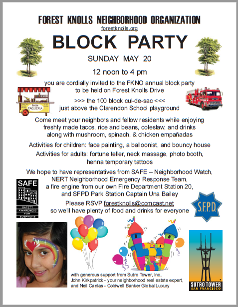
I got an email requesting me to post this notice about the Forest Knolls Block party…
It’s on Sunday May 20th 2018, from 12 noon to 4 p.m. and will be held in the 100 block cul-de-sac of Forest Knolls Drive (that’s just above the Clarendon School playground.) There’ll be snacks (tacos, empanadas) and drinks, a bouncy house, balloons, a fortune teller and a photo booth and more. Representatives from SAFE – Neighborhood Watch, the NERT Neighborhood Emergency Response Team, and from the Fire Station and SFPD may be present. Please RSVP to Walter Caplan at forestknolls@comcast.net
You can also download the flyer above as a PDF here: 2018-block-party
I was taking the Muni downtown yesterday, when a Muni employee stopped me. She handed me the flyer below, and told me the station would be closed weekend nights (Friday and Saturday) from 11 p.m. to 9 a.m. It’ll last through June 17th, and they’ll have buses. All the details are available at SFMTA.com, or on 311.
I really appreciated the outreach. I’m seldom that late on the Muni, but when I am – it’s often a weekend.
It’s that time of the year again, and whatever festival you celebrate, I’d like to wish everyone reading this blog a very joyous one! And here’s to a good year ahead in 2018.
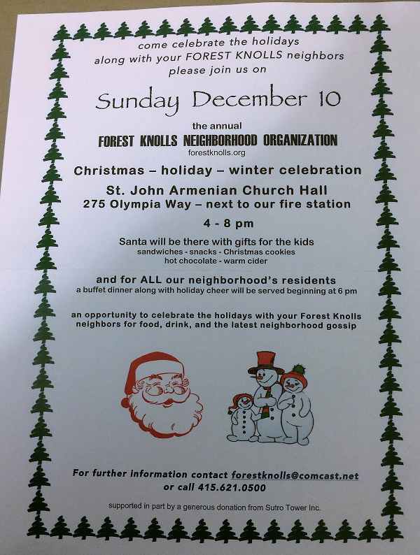
We got a notice about the annual holiday party… you probably received it in your mailbox, but in case not, here it is!
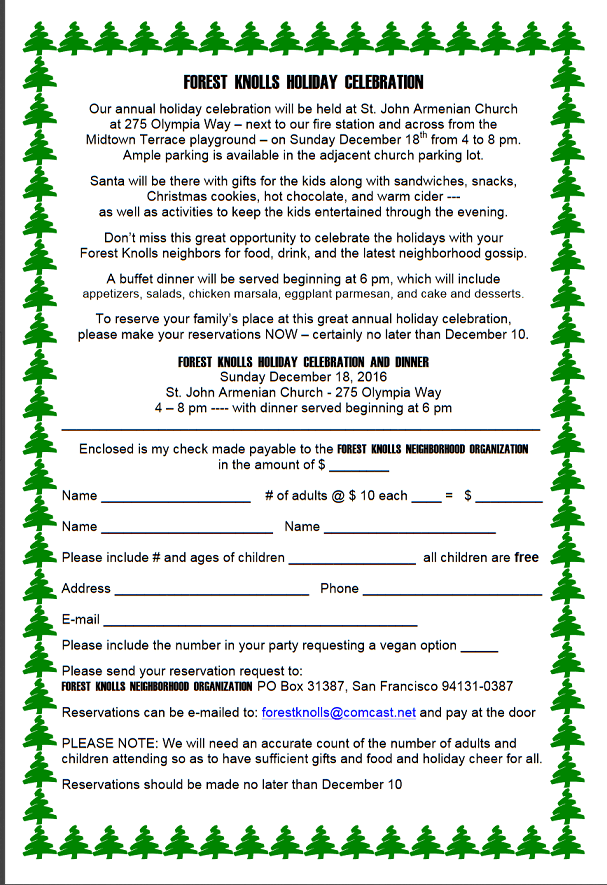
The Forest Knolls Holiday Party is set for Sunday, 12/10, from 4-8pm with a dinner buffet at 6pm. The event will be held at the Armenian Church on Olympia, next door to our fire station.
If you plan to attend, PLEASE RSVP to forestknolls@comcast.net. Indicate the number in your party and ages of kids attending. For members of the Forest Knolls Neighborhood Organization (FKNO), the price is $15/person. Non-members are $20/person. Kids are free. Please use the self-addressed envelope you received in your mailbox to pre-pay and/or join FKNO.
It’s that time of the year again, with the orange flyers in your mailbox, telling you about the Halloween loop. The Forest Knolls Neighborhood Organization does this each year.
If you’re on the loop and want to trick-or-treaters coming by, you’ll need to be home on Tuesday Oct 31 between 5.30 and 8 p.m. (with candy!). Email the organizers by Sunday Oct 22 at
forestknolls@comcast.net or call them at 415-621-0500.
They’ll give you a pumpkin and a sign to indicate you’re participating.
If you want to take your kids trick-or-treating, bring them to the loop between 5.30 and 8 pm. on Oct 31 – and look out for the pumpkins of participation!
I was driving west along Clarendon Avenue, heading homeward. As I slid into the turn lane to make a right on Christopher, something white lay on the side of the road. I slowed nearly to a stop, unsure what it was. Then I recognized it as a barn owl, wings spread. My fear was that it might be injured, perhaps from hitting a car.
To my relief, it rose into the air and disappeared into the trees of Sutro Forest, a rodent clutched in the talons of its right foot. It must have just caught it.
But I was in even more luck! As I turned right, it sailed out of the forest ahead of me, looped over Christopher Dr, and flew back to a tree beside the street. Then it took off again, but only went a little deeper into the forest.
Later, I went back. The owl was there, but difficult to see in the darkness. I heard rustling sounds that suggested it was eating the rodent it had caught. I tried getting photographs, but both my phone and camera rebelled at the darkness. This picture is an edited public domain photograph.
This article is taken (with permission) from the SaveSutro.com website. It says UCSF’s Plan for Mount Sutro – which could start as early as this winter – could directly increase the risk for our neighbors on Christopher and Crestmont.
I started thinking about it. It’s a pretty insidious. The cutting of trees, and widening of the road to use heavy machinery and trucks up above our neighborhood could have very long-lasting effects – for five to ten years after the project, according to the research. Nothing might happen immediately – and then along comes a really wet stormy winter and whoosh!
Is this something real estate agents will have to disclose? I don’t know. And if something does happen – what’s the insurance situation? (I’m not even going to think of the risk to families living there.)
Anyway, this article is to let our Crestmont and Christopher neighbors know about these concerns. There’s more about the UCSF 2017 Plan on SaveSutro.com
Recently, we wrote that the Sutro Forest 2017 Plan Imposes a Landslide Risk. A University of Washington study shows that mudslides are most like 5-10 years after trees have been cut down on slopes. The picture below shows the South Ridge, which will be directly affected.
But it’s not just the tree-cutting. UCSF is widening two major trails into roads fit for heavy equipment, and adding nine quarter-acre “staging areas” for machines and felled trees. Both the roads are above Forest Knolls. (The heavy yellow lines in the map below are the new roads. The red squares are the locations of the staging areas, each of which will be a quarter acre.)
The picture at the top of this article gives some indication of how steep the hillside is. And the roads above Forest Knolls are atop a slope *known* to be unstable. Look at this landslide hazard map:
The double black arrows show landslide direction. The wiggly black arrows show soil creep direction. All those dark green areas? Potentially unstable. All the gold areas? Also potentially unstable.
Though the Draft Environmental Impact Report claims it’s making safety its first priority – it doesn’t look like it. In attempting to mitigate one (overstated) concern (dead trees falling), they’re worsening the risk of landslides.
Yesterday, I was horrified to receive this letter from some Forest Knolls neighbors. This is re-posted with permission. We stand with them against hatred.
[Edited to Add: If you want to email them in support, please use this email address: TamayoLee2017 at gmail.com ]
Dear Neighbors,
First Amendment Rights are being threatened here in Forest Knolls.
We are writing to you to seek your support for ensuring that residents of our neighborhood can express themselves without threats or fear of harm. Since late 2014 or early 2015 we have had a Black Lives Matter poster in our living room window at 11 Christopher Drive. No incidents have occurred because of the sign.
However, in mid-July 2017 we received an anonymous note in the mail addressed to “RESIDENT, 11 CHRISTOPHER DRIVE, SAN FRANCISCO, CA 94131” with the message “BLUE LIVES MATTER! Get rid of your sign, or WE will!”. We did not take any action at that time.
However, another note was mailed addressed to ‘BLM, 11 CHRISTOPHER DRIVE, SAN FRANCISCO, CA 94131″ postmarked August 14, 2017 – the Monday after the tragedies in Charlottesville, VA — which stated “It’s time to replace your BLM sign. How about CHINK LIVES MATTER”. (“Chink” is an anti-Chinese slur originating from the turn of the 20th century.) We reported these notes to the FBI and to the SFPD Park Station on August 17. We surmise that the notes were from someone who passes by our house on a regular basis and is aware that we are of Asian descent.
We placed the BLM sign in response to a national concern that African-Americans were not only victims of deadly violence but also suffered ongoing discrimination and disparities in health, education, job opportunities, etc. In June 2015, nine African-American members of an African-American Methodist church in Charleston, South Carolina were murdered in cold blood by an avowed racist. And as the recent events in Charlottesville point out, our concerns of a rising intolerance to people of color and immigrants are not unwarranted. We are sharing this experience with you as our neighbors so that we can ensure that all our lives are safe and that we can all continue to exercise our rights to post the BLM sign or display any other political statement of our choosing. (The sign was taken down in August as a safety precaution for houseguests, but it will be back up very soon.) We also want to make sure that our neighbors and other San Franciscans are not silenced.
We have lived at our house since January 1993, nearly twenty-five years. We have enjoyed our home, tending our colorful flower garden, creating art on our side fence, walking in the newly expanded trails of UC’s forest and meeting others at the reservoirs/ Tank Hill with our dog as well as at Forest Knolls back bench social and summer street parties. We are natives of San Francisco and our children have attended SFUSD from kindergarten to senior year.
Debbie is a Senior Vice President for Futures Without Violence, a national non-profit addressing domestic and sexual violence and child trauma, where she has worked for over thirty-five years. She and her mother have tended our front garden over the last fifteen years. Bill is the District Director for the U.S. Equal Employment Opportunity Commission and earlier served as the EEOC Regional Attorney for twenty years. Civil rights protections are very close to our hearts and we have dedicated our whole professional lives to that cause.
We have contacted Supervisor Norman Yee’s office and plan to meet with him soon. We are open to your ideas and suggestions to send a message that our neighborhood supports First Amendment rights and will not allow residents to be intimidated with racist threats. If you want to post a Black Lives Matter sign or any other sign to express concern and/or outrage, please do not hesitate to contact us.
Thank you for your support.
Bill Tamayo Debbie Lee Celi Tamayo-Lee
This article is reprinted from SaveSutro.com with permission. The landslide hazard described touches our neighborhood; Christopher Drive and Crestmont are both in Forest Knolls!
This is risk that may actually increase over the years as a result of actions being taken now, for two reasons.
First, tree roots take time to die and rot, but when they do, they weaken the living geotextile that stabilizes the hillside.
Second, trees take up water and help to regulate moisture deep in the ground. When large trees are cut down and stop doing this, small saplings and ground cover are not an effective substitute. So if the trees are cut in dry or normal years, nothing may happen for a while – and then a really wet year can trigger landslides that would not have happened if the trees had remained.
Landslide under blue tarp. South Ridge at top left.
We’re reading the Draft Environmental Impact Report (DEIR) for the 2017 Sutro Forest Plan, and got to the section on landslide risk. This has been one of our concerns, especially since the tragedy at Oso, Washington, where the felling of trees in previous years was a factor in destabilizing the slope. (We wrote about that HERE: Cut Trees, Add Landslide Risk) We know this area is subject to landslides – we had a blue tarp covering unstable areas in Forest Knolls for a year when cutting trees destabilized a slope, and another just above UCSF’s Aldea housing area.
SHOCKING LANDSLIDE INFORMATION
We were shocked at what we found in the DEIR: “Increased instability could cause a landslide that would impact Crestmont Drive, Christopher Drive, and Johnstone Drive. An existing landslide scarp is visible above Christopher Drive. Some homes along Christopher Drive could be placed at additional risk from localized landslides due to plan implementation. Phase I activities would result in a potentially significant impact…”
The map above is taken from the DEIR. All the dark green areas are potentially unstable. All the gold areas are potentially unstable. All the cream areas are potentially unstable. The little red blobs and stars are already unstable. The black arrows show the direction of potential landslides – right into our communities. Here’s the key to the map. The light yellow and light green areas are where they are cutting down trees in Phase I (five years, starting this fall – 2017):
Legend to Landslide Hazard Map Sutro Forest 2017
What’s the proposed “mitigation”? Avoiding work in the forest for 2 days when the soil is wet after rain. This completely ignores the fact that landslides are a MULTI-YEAR hazard after tree removal.
Here’s the proposed mitigation in their own words:
“After a significant storm event (defined as 0.5 inches of rain within a 48-hour or greater period), the following conditions shall be met prior to any vegetation management activities:
The maps detailing areas of historic slope instability or rock fall in the Final Geotechnical and Geological Evaluation Report for UCSF Mount Sutro shall be reviewed (Rutherford + Chekene 2013)
If ground-disturbing or vegetation removal activities are proposed within or adjacent to areas of historic slope instability or rock fall, the saturation of the soils shall be estimated in the field; if muddy water drips from a handful of soil, the soil is considered saturated (Brouwer, Goffeau and Heibloem 1985)
The areas of historic slope instability or rock fall shall be flagged if the moisture content of the soils is determined to be high (i.e., muddy) and ground-disturbing or vegetation removal activities shall be avoided for a minimum of 48-hours after a significant storm event to permit soil drying…”
In other words, we won’t chop down trees in the rain or when the soil is wet.
Other mitigations are palliative. They’re planning to build roads into the forest for trucks and heavy equipment, and those roads will follow the contour of the slope. The quarter-acre staging plazas – where they’ll remove trees so trucks can turn around and heavy equipment be parked – will be flattish, with a slight slope for drainage. None of this is as effective as not building these roads or bringing in heavy equipment in the first place.
WHY THE MITIGATION IS MEANINGLESS
The problem is, the effect of cutting down trees is a LONG TERM problem. The effect of tree removal takes years – not days, not months – to fix. In Oso, Washington, the slope gave way three years after the last tree-destruction. Here’s the story (from the article we published at the time). The tragedy was foreseen… but the regulators thought they had enough mitigations in place.
On March 22, 2014, a huge landslide destroyed the small Washington community of Oso. Rain was of course a factor, as was erosion at the base of the slope. But it’s probable that tree-cutting above the slide area was an important factor too. An article in the Seattle Times that quotes a report from Lee Benda, a University of Washington geologist. It said tree removal could increase soil water “on the order of 20 to 35 percent” — and that the impact could last 16-27 years, until new trees matured. Benda looked at past slides on the hill and found they occurred within five to 10 years of harvests [i.e. felling trees for timber].
There had been red flags before. The area was second growth forest, grown back from logging in the 1920s/30s. Over 300 acres were again logged in the late 1980s.
The first time regulators tried to stop logging on the hill was in 1988. But the owner of the timber successfully argued that measures could be taken to mitigate the risk. Eventually, the state only blocked it from logging some 48 acres, and the owners gave in on that.
In 2004, new owners applied to cut 15 acres; when the Department of Natural Resources (DNR) objected, they halved the area and re-located the cut. DNR gave approval, subject to no work during heavy rain and for a day afterward. The tree-cutting finished in August 2005.
In January 2006, there was a major landslide 600 feet from the cut zone. The state built a log wall to shore up the slope.
The owners continued logging. In 2009, they removed 20% of the trees. In 2011, they removed another 15%. In 2014, the hillside collapsed.
The regulators were aware of the risk; they thought they were mitigating it with their restrictions and reaching a compromise with the owners. But it wasn’t enough. Destabilizing the mountainside is a long-term thing; the effects can show up in months, but it’s more likely to take years.
THE LESSON FOR MOUNT SUTRO
Our mountains not only are potentially unstable, they actually have landslides. The picture at the end of this article shows one on Twin Peaks, where rocks tumble after nearly every heavy rainy season.
The roots of the trees are helping to hold the unstable soil in place and that as the roots rot, landslide risk will increase. It is going to be more unstable 2-3 years after the trees are removed than 2 days after it rains. The information that instability increases over time is a little counter-intuitive.
Moreover, removing the trees takes away their ability to suck water out of the soil. If the tree-cutting is done in dry years, it may take a wet winter to trigger landslides… which would not have happened if the trees had been regulating the water and functioning as a living geotextile.
Since UCSF are not going to use herbicides on the stumps to prevent them from resprouting, they say they will grind the stumps. That is an effective way to prevent resprouting, but it will greatly increase the instability of the soil because the heavy equipment digs down several feet into the stump to destroy the roots. That’s another reason why they should not destroy trees where slide risk has been identified.
Anyone seriously considering the map above can only hope that UCSF will draw a better conclusion than the Washington State loggers and regulators. The planned destruction of thousands of trees – many within the first five years – could cause landslides in surrounding communities not days or months later, but years after the event.
Here’s an announcement from Barbara Oleksiw, who organizes great neighborhood events in the Inner Sunset. (Thanks, Barbara!):
Sunday, April 16, 2017 – 10a.m.to Noon
NW Corner of 6th & Irving, Inner Sunset,
ALL Welcome to the **FREE** Easter Egg Hunt, in the Inner Sunset. Rain or Shine, 10 a.m. to Noon.
Hundreds and hundreds of hidden eggs waiting to be found.
We’ve known for years that coyotes are all around us in Forest Knolls – I wrote about it here when a couple of neighbors reported seeing them. (LINK: Coyotes Among Us)
But this time, neighbor Michelle Lukban got this really neat picture (published here with permission). For everyone who’s been jealous of Bernal Heights coyote pictures, we got ours! [Edited 3/27/17 to correct attribution of picture]
BEING CAREFUL AROUND COYOTES
Janet Kessler, the Jane Goodall of SF’s coyotes, has for many years been observing, photographing, and reporting on our San Francisco coyotes. Her website is at CoyoteYipps.com. She’s also involved with Coyote Coexistence, an organization that helps people and coyotes to co-exist safely.
For guidelines on staying safe – and keeping pets safe – around coyotes, click on this LINK: Coyote Coexistence Guidelines
And here’s a 30-minute video on the subject.
Coyotes are not very concerned about people, and are generally quite shy of them. But they are very interested in dogs. Coyotes are territorial animals, and dogs could be considered interlopers. Also, some dogs chase coyotes, and so coyotes may feel threatened. Often the coyote will remember which dog it was. Don’t let your dog do this. It could be dangerous for both animals. Finally, really small dogs – and cats – may be viewed as prey. This is rare, but it has happened. If you have pets, the video above may be useful.
But it didn’t proceed. Instead, it was put up for sale.
SF Overlook Project on a very steep slope – Google Maps image
FOR SALE AT $14 MILLION
In May 2015 SocketSite reported that the site was for sale, with the plans for the units (but without building permits).
In January 2016 they reported that the asking price, initially $20 million, had been cut to $15 million.
And in November 2016, they said the price had been cut to $14 million.
Hmm. According to a November 2016 mailing I received from realtor John Kirkpatrick, homes in the Forest Knolls neighborhood sold for an average of $1.195 million. Forest Knolls homes have 2 or 3 bedrooms and 1 or 2 bathrooms, but the back half of the garage typically offers customizable space. You can put in another 2 rooms and bathroom down there if you want. They’re standalone homes with no shared walls and most of them have a yard. That’s the competition to this project.
Let’s say these 29 luxury homes are priced at about $1.5 million, because they’ll have the latest fit and finish. Other benefits, like a 2-car garage and views are not unique to the development.
That would be a gross take of $43.5 mn, roughly 3 times the asking cost of the land and plans. Is it worth it? I don’t know.
ACCESS IS STILL AN ISSUE
Though there’s an agreement with the Mt Sutro Woods HOA, the project’s only access runs through the very narrow Crestmont Drive, which has houses on one side and a steep hillside on the other. Though on the map it looks like you could easily link it up to 5th Avenue, the intervening land doesn’t belong to the developer and is also very steep.
The way in to these 29 would-be homes is through the Forest Knolls neighborhood. Fears of destabilizing the mountainside where many homes are supported by concrete piers, fears of added traffic on an already narrow street, fears of potential emergency situations with very poor access, all could fuel more opposition.
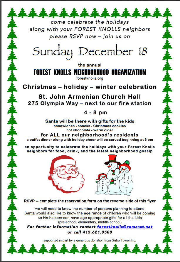
Walter Caplan of the Forest Knolls Neighborhood Organization asked me to post this “save the date” for the Forest Knolls Holiday Party. It’ll be at the Armenian Church at 275 Olympia Way, on Dec 18 at 4 p.m. – with snacks, dinner, Santa, and gifts for children.
Unlike previous years, there’ll be a $10 per adult charge to cover costs. Children are free! If you wish to attend, please fill in the form below (or still better, in the linked PDF file) and mail it in with your check.
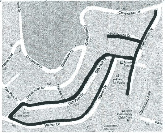
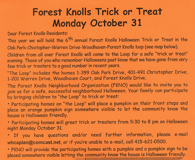
It’s that time of the year again! You may have seen the orange flyer in your mailbox or on the fence at the entrance to Forest Knolls: “Forest Knolls Trick or Treat Monday October 31”
Each year, the Forest Knolls Neighborhood Organization (FKNO) encourages neighbors on Oak Park and Warren Drive (and a small stretch of Christopher) to join the “Loop” – a Halloween-friendly route that kids can trick-or-treat on.
This year, it’s been expanded to Forest Knolls Drive and Woodhaven Court. It runs between 5.30 and 8 p.m. People who want to greet kids with candy can get a pumpkin and a pumpkin sign to let them know they’re in. FKNO will provide both pumpkin and sign – email Walter Caplan at whcaplan@comcast.net
Here’s the map. If anyone wants to send me pictures afterward (and maybe a few lines about the event?) I’d be happy to publish them.
One of the delights of living where we do is being so close to wildlife. I don’t mean just the raccoons or the hawks – but actual whales! I’d been seeing Youtube video of humpback whales in Pacifica, barely 15 minutes south of us.
So I went out to Pacifica Pier around 4 p.m. on a sunny Saturday afternoon, hoping that I’d maybe see a whale. I was disappointed to find access is truncated – the pier is shaped like a shallow L, but the short arm was closed off after a big storm damaged the parapet. (In the picture below, you can see the concrete slab of the wall has been pushed in by the waves. I wish they’d repair it!)
In the fine weather, the Pier was crowded. Lots of people were fishing, lots of others walking around. My hopes rose when I saw a couple of people armed with cameras with lenses as long as my forearm… maybe they were seeing whales? I only had my iPhone camera, but thought maybe I’d get some distant sightings.
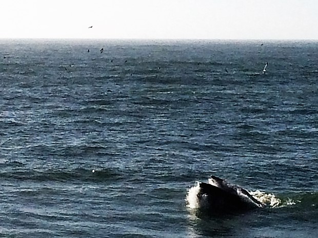
I didn’t have to wait long. Almost immediately, I could see the puffs of whale-spouts in the distance, north of the pier.
Humpback whale spout off Pacifica Pier
Soon I could even see the whales when they surfaced. Flocks of birds surrounded them. As they fed, the fish that escaped them fed the gulls and other sea-birds. After I’d been there an hour or so, I wanted to leave. Except, I couldn’t. Every time I started to leave, more whales swam by.
Finally, one came in so close, it was inside the surf line. Someone next to me was explaining to a friend that it was likely a calf, and the shallow water was easier to breathe in. It was almost alongside the pier. After a minute or two, it turned around and swam back out.
Our neighborhood doesn’t see much crime, so it was surprising when neighbor Florence Meyering posted on NextDoor that there were police on Clarendon Avenue with guns drawn! (This was on 23rd July 2016 around 5.30 p.m.)
“As I was driving on Clarendon/Twin Peaks Blvd, I saw police with guns out and police cars were arriving from everywhere. They were looking at the hill towards Mount Sutro Forest. Does anyone know what was going on and if they caught whomever were were after?” she posted, along with the picture above.
So I wrote to Park Station police, and they wrote back within a couple of days: “On that date and time, there was a carjacking that occurred. I believe officers were most likely responding to this incident. The suspect is in custody and the stolen vehicle returned to it’s rightful owner.”
Are you a short-term rental host? (AirBnB, VRBO, even on Craigslist – anything less than 30 days at a time) The city of San Francisco requires you to register. Walter Kaplan asked me to publish this PSA:
Forest Knolls residents who wish to act as a short-term rental host MUST register with the City’s Office of Short Term Rentals.The City is hosting a registration event at the Ortega Branch of the San Francisco Public Library on Thursday May 5, from 5:30 to 8:30 PM. There will be walk-in registration, and no appointment is required.
Here’s the original message from the city:
Hi. Here is the information on the upcoming (City-run) registration event at the Ortega Branch of the Public Library. Feel free to share with your neighbors.
Short Version: If you plan to host short-term rentals (including through websites such as VRBO, Airbnb, & Craiglist) in your home, then registration is required with the City’s Office of Short-Term Rentals. A walk-in registration event (no appointment required) will be held at the community room of the Ortega Branch Library, on the evening of May 5th from 5:30 PM to 8:30 PM. For more information visit http://www.sfgov.org/OSTR.
Long Form Version:
The San Francisco Office of Short-Term Rentals is offering additional opportunities to apply for registration as a Short-Term Rental host** or just to ask questions.
At the Ortega branch (3223 Ortega Street – meeting room) of the San Francisco Public Library on the evening of May 5th, from 5:30 PM to 8:30 PM. Walk-in registration (no appointment required). This is not a library sponsored program.
Walk-in registrations (no appointment required) at 1660 Mission Street (inside the Dept. of Building Inspection), on the 5th floor, on every Wednesday afternoon, between 1:00 PM to 4:00 PM.
Evening walk-in registrations (no appointment required) on the first Monday of every month, from 5:30 PM to 7:30 PM, at the Planning Department. Located at 1650 Mission Street, on the 4th Floor.
At the Earthquake Retrofit Fair on April 18th from 3:00 PM to 7:00 PM, at Bill Graham Auditorium, located at 99 Grove Street. No appointment required.
Registrations can also be handled, by appointment, on most weekdays (at 1660 Mission Street), and take about 20 minutes. Appointments are held at 1660 Mission Street, on the 5th floor. Appointments can be requested online at http://www.sfgov.org/OSTR.
Having a complete application and required documents (listed on Page 3 of the application form) can help speed up review and approvals after the registration event or appointment.
Registration is required with BOTH the Office of Short-Term Rentals AND the Office of the Treasurer & Tax Collector.
For more information on the application requirements, including documents needed in order to register visit http://www.sfgov.org/OSTR.
Hosting Short-Term Rentals WITHOUT being registered with the Office of Short-Term Rentals can result in daily fines. The City’s Administrative Code (Section 41A) requires registration if a permanent San Francisco resident would like to host short-term rentals in their home. To file a complaint about a Short-Term Rental, or if you have any questions please contact us at shorttermrentals@sfgov.org or (415) 575-9179.
**Short-Term Rentals are for stays of 30 days or less, that are hosted in residential dwellings. This includes if you offer stays in your home through the use of online platforms such as: Airbnb, Craigslist, Flipkey, HomeAway, and VRBO.
Regards,
OMAR MASRY, AICP | SENIOR ANALYST
Office of Short Term Rentals, City & County of San Francisco
omar.masry@sfgov.org
P. 415.575.9116 l F. 415.558.6409
1650 Mission Street | 4th Floor | San Francisco | CA 94103 http://www.sfgov.org/OSTR


 Here’s a larger map of the route: