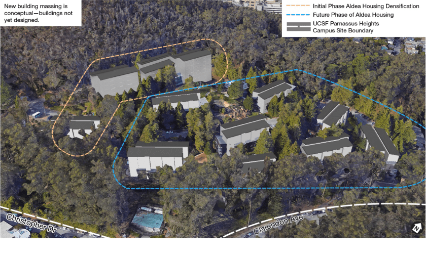
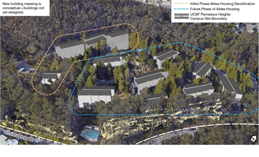
UCSF has revealed its plans for Aldea Housing. Back in 2014 when we reported that UCSF was removing Aldea student housing from the “space ceiling” that limited its expansion in the Parnassus area, we weren’t told what was planned. Now it’s been described in the 2020 DEIR (See the whole document here: UCSF-CPHP-Draft-EIR (1) ) Sept 11, 2020 is the last day for comments.
The plan is to demolish the existing low-rise wood-shingled buildings, and replace them with tall ones. The first phase will be three 8-storey and one 5-storey building. Here’s their impression from the DEIR document.
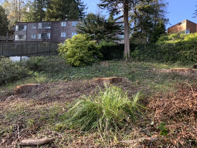
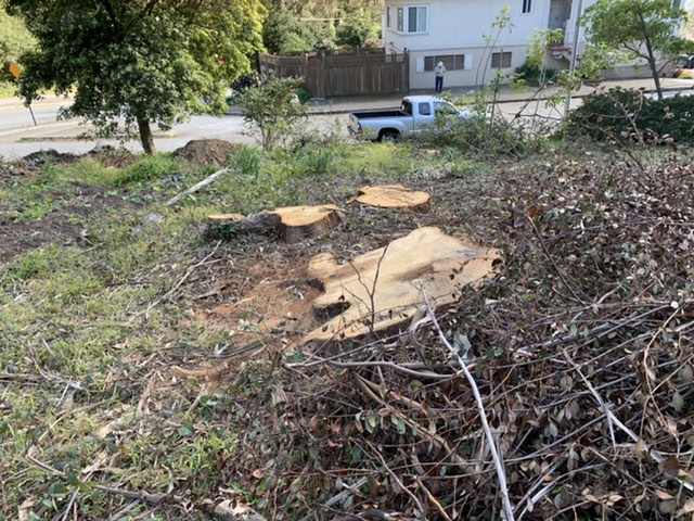
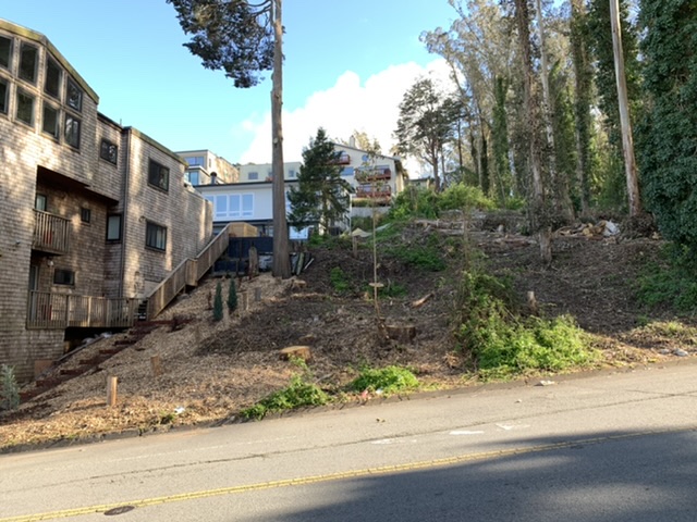
One of our concerns is that they’ll remove even more trees to accommodate the new buildings and the construction space to build them. We can probably expect most of the forest lying between Forest Knolls and the Aldea Housing to be thinned to the point that it is merely a few trees standing around instead of something resembling a wood.
Here’s what it looked like in 2013, when I was concerned about *two trees*!
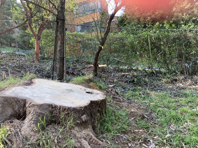
Well, the trees have all been cut down, I think by UCSF.
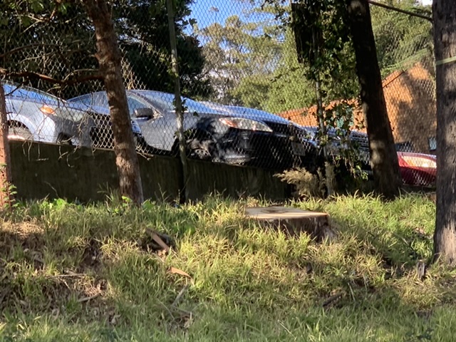
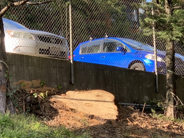
There’s no grove between Clarendon and the pumphouse, just a couple of trees left.
These were beautiful old trees – maybe around 125 years old. All that is left are stumps.
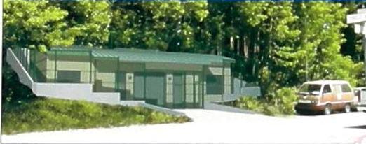
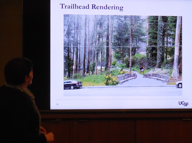
Meanwhile, the planned trailhead from Clarendon is being built. It’s going to look *very* different from the charming visualization presented by UCSF.
CLARENDON LOSES ITS CENTURY-OLD TREES
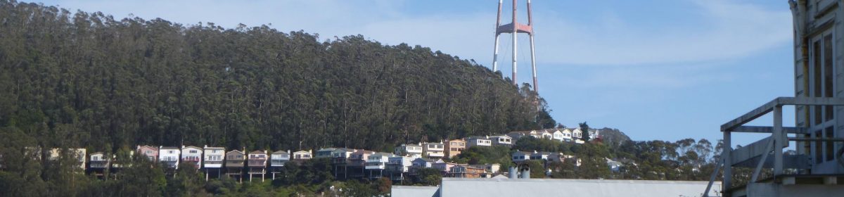
Also gone – the tall trees that lined Clarendon Avenue in front of the Aldea San Miguel UCSF student housing.
I remember a time when you couldn’t even see the fence from the street. When UCSF thinned the vegetation there many years ago, they promised plantings that would conceal the chain link fence. Well, they planted some vines, but the concealment didn’t happen.
The chain-link fence is more prominent than ever.
And across the road, a swath of trees adjacent to the homes on Clarendon have been felled too, I think by SF Rec and Parks (or possibly Sutro Tower, not sure).
Over the last decade, we have lost a lot of the glorious trees that made Forest Knolls a community surrounded by forest. I’m glad I had a chance to see them in their former beauty.
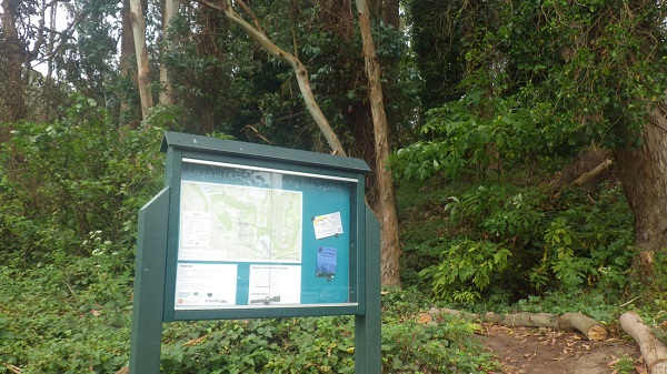
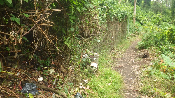
Recently, I saw a new trail marker/ map on Clarendon Avenue, across the street from “The Woods” townhome complex, and decided to explore.
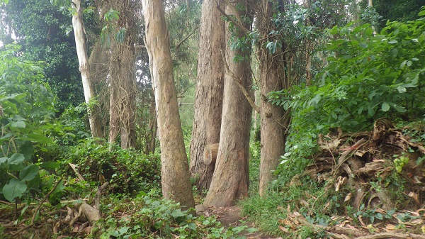
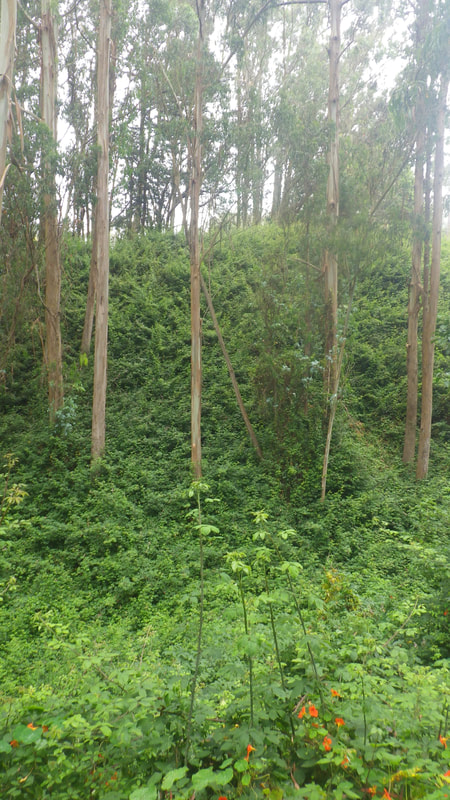
It goes through the ravine that probably was part of the lake in olden times. It’s now dry, and forested with eucalyptus and understoried with blackberry. Laguna Honda Hospital (LHH) gets it cleared out occasionally with goats. It’s quite delightful, a narrow winding trail that climbs up the other side of the ravine and comes out in LHH’s front yard.
Hiker and blogger Tony Holiday tried out the same hike – though he went a bit further, beyond the juvenile detention facility – and has given me permission to use his story and some pictures here. (For lots more great pictures, see his blog post, Daisies, on his site Stairways Are Heaven. It’s also a great resource for transit-friendly hikes.)
* * *
From DAISIES by Tony Holiday
Thanks again to a good Facebook friend who told me about a new multi-use trail. And it’s a beauty!
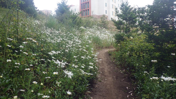
The trailhead is on the Midtown Terrace side of Clarendon, just past Laguna Honda Reservoir. This is the south side of Clarendon, across the street from “The Woods” residences. There’s a sign with a map at the trailhead. It’s also a short distance from Olympia Way and the Midtown Terrace Playground.
Does this trail have an official name? If not, how ‘bout the “Woods” Trail?
Loved it immediately. Lush, narrow, definitely magical, with beautiful old trees.
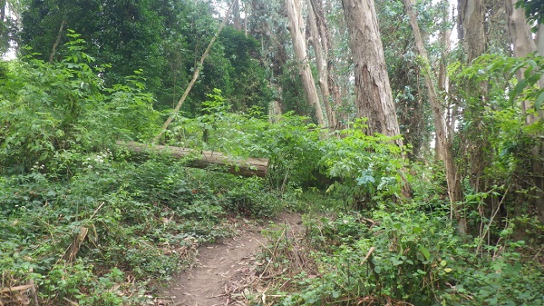
It curves round, winding up to a south ridge.
No one on the trail but me (and Karl the Fog).
Nearer the summit was chainlink fencing and some old trash just off the trail. The cans, etc. will probably eventually be cleaned up. An old dumpsite for Laguna Honda Hospital?
To my left as I climbed were backs of Dellbrook Ave. homes. To my right, above, some of the many hospital buildings, old and new.
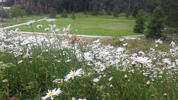
Then there were all these amazing white daisies along the trail.
There are benches just inside the hospital grounds behind one of the buildings. Still no one around but me. Continued up to a way out at a hospital parking lot.
From here delighted to see more woods just ahead.
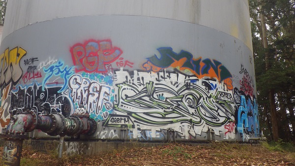
Hidden away in the forest here are two huge graffiti-covered tanks.
Started down (west) alongside the hospital grounds to my right; to the left the Juvenile Probation Dept. Down at street level was Woodside & Idora. Continued curving downhill to the #43 bus stop that’s just across from the Forest Hill Metro Station.
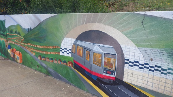
Another treat —the colorful mural at the entrance to the hospital grounds on Laguna Honda at the bus stop. I think this has to be my favorite of all murals seen so far. [For lots more mural photos, see Tony’s original blog post.]
Squat and Gobble, the West Portal eatery that was being rebuilt after the fire there, had sought approval to remove a tree to provide heavy machinery access to the site. (I’d thought it was two trees that were scheduled for removal, but it was one.) But, as I reported then, work was well underway and both trees were still there. I was glad; West Portal has lost some beautiful trees, most notably an old one near the tunnel entrance when work was done there.
I wrote to Carla Short at the Department of Public Works, asking if the trees had been saved. She didn’t know. She replied:
As for the West Portal trees, only one tree was approved for removal in order to accommodate the crane for construction. I have not heard that they are planning to preserve that tree, so it may be still coming out. Their permit is valid for six months. If they found a way to work around it, though, perhaps they are preserving it, I just haven’t heard anything. If it does get removed, they will be required to plant a replacement tree, and some additional trees on the West Portal frontage.
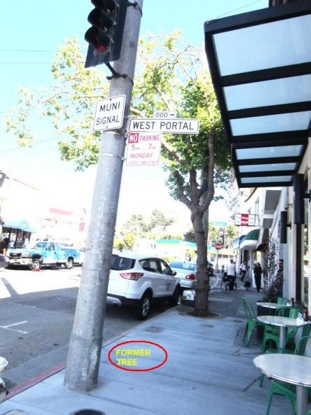
Well, the tree was there through much of the construction, but when Squat and Gobble reopened, I found it was gone. Even the tree-basin the tree had grown in was gone. There’s no replacement tree there, nor any along the West Portal frontage. I hope they’re planning to put them in.
It’s just one tree, and it was removed through a proper permitting process. But I’m beginning to see an anti-tree ethos in this city. Whenever there’s a project, whether private or City-led, trees are the casualty. There seems to be no emphasis on trying to preserve and work around them.
“The tree which moves some to tears of joy is in the eyes of others only a green thing that stands in the way.” – William Blake, The Letters, 1799
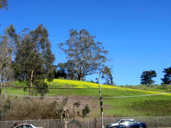
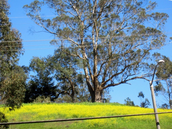
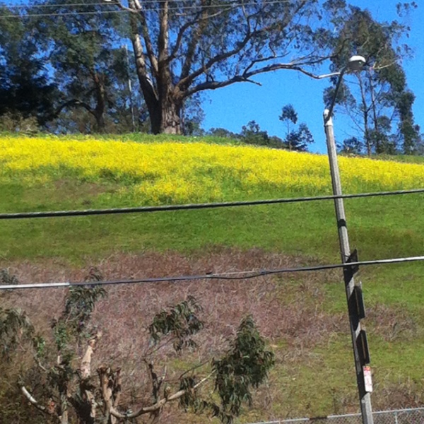
You don’t have to go to Napa to see the brilliant yellow of mustard flowers – they’re blooming right here in the hilly meadow of Laguna Honda Hospital, above Laguna Honda Boulevard.
I stopped to take a picture, and as I zoomed in, was struck by the grace and grandeur of the eucalyptus tree above the meadow.
And here’s a picture from a smartphone… this week’s sunny weather provides such a classical contrast of colors!
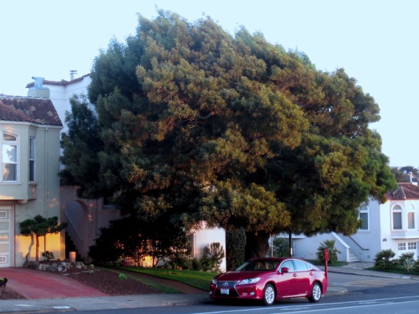
This tree is near West Portal, and I pass it probably twenty times a week. I’ve admired it for years. It dominates the street; there’s no other tree of that size or beauty near there.
A few years ago, I was writing a piece on Memorable Trees, and wanted to add this one. But around that time, the owners had it pruned. It was very well done, not butchered, but still the tree looked shorn, like a child after the kind of haircut you get them when you don’t want to have to struggle with it too often.
For a tree, unlike a kid’s hair, it takes quite a time to come all the way back. In the last year or so, I’ve been noticing it again, and I thought I’d better get photographs before it’s time for another pruning.
To the owners of the tree, should they encounter this post – Thank you!
Thanks for caring for it. It’s a grace to the whole community.
A few months ago, I reported that the two trees were marked for removal, next to the burned-out Squat & Gobble restaurant on West Portal. Though they’d survived the fire and the fire-fighting, they were in the way of the cranes that would be needed for rebuilding on the site.
It was sad. So many trees were being lost. There used to be a splendid old tree at the station, opposite the library; it was removed when work was done on the Station.
But… here it is, mid June. The rebuilding is coming along nicely.
And our trees are still there.
If they have indeed been saved, a big thank you to whoever preserved these trees.
The San Francisco Forest Alliance and Save Sutro Forest are holding a meeting on 21 April 2013 to talk about the planned felling of trees on Mount Sutro — and on Mount Davidson. These actions would gut two important urban forests near our neighborhood and irretrievably alter the landscape.
Do you want to know:
How many thousand trees do they plan to cut down on Mount Sutro? On Mount Davidson?
Who’s “They”?
What about Pesticide use?
When will this happen?
For answers to these questions and more…
Come to the San Francisco Forest Alliance meeting.
WHERE: Miraloma Park Clubhouse, 350 O’Shaughnessy Blvd,
San Francisco, CA 94127
(It’s about 2 miles from Forest Knolls.)
WHEN: April 21st, 2013 (Sunday) – 4.30 p.m. to 6.30 p.m.
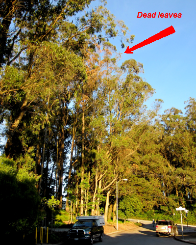
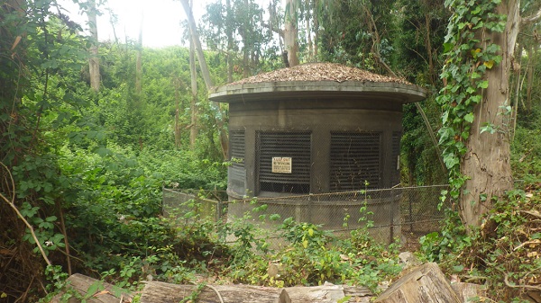
In the last day or two, I’ve noticed that one of the trees that screen our neighborhood from the UCSF Student Housing is brown rather than green. It’s a eucalyptus, and they don’t change color; in fact, if anything, they’re greener when it rains. So I went to have a closer look at this tree, which is one of the group by the Pump House at Christopher, just off Clarendon.
I wondered if it might have been girdled. “Girdling” is a process of killing a tree by cutting all round it, and has been used by Native Plant activists to kill trees in “Natural Areas.” One example it the Murdered Tree on Mt Davidson, clearly visible from Portola.
Looking more closely at the tree, I didn’t see any girdling marks. I also saw it was dying in parts, which I think is more consistent with poisoning. (It’s not very clear from the photograph above – if anyone wants to take a better pic and send it over, I’ll add it here.)
In the tree beside it, someone had stuck blue plastic marker flags from The Urban Farmer Store. I’m wondering if this tree – and maybe the ones beside it – is being poisoned by some eucalyptus-hater.
If so, it’s illegal. A tree can’t be killed along a public right-of-way without a proper 30-day-notice posting, which the Department of Public Works would do. (Or, if this is UCSF property, then UCSF would do it.) There’s a process that applies.
Even more importantly – it’s incredibly irresponsible. Poisoning a tree across the road from someone’s home will leave a weakened or dead tree standing near a residential house. Even before that, it could drop branches on cars parked beneath.
I really really really hope I’m wrong on this one. I have a hard time believing that anyone could be so stupid.
[Edited to Add: I contacted UCSF; I was hoping they might get an arborist to determine what happened. If they did that, I don’t know about it. But they thought the trees might be the responsibility of the Water Department. In any event, three of the trees have been removed. One is still dead and still there, but it does not look like it’s a hazard. If anyone would like to follow up further, let me know.]
The article below is republished with permission from Outsidelands (with some added emphasis). Click HERE for the original article. I want to thank Rex Bell for a wonderful step back in time.
———————————–
A WALK ALONG THE ALMSHOUSE ROAD:
A Historical Description of Today’s Clarendon Avenue
by Rex Bell
I’ve always been fascinated with San Francisco history. To indulge my interest, I sometimes try to imagine what areas of the City I’m so familiar with were like in the past. I recently got a little help when I discovered a detailed, descriptive article that appeared in the San Francisco Call on Sunday, November 8, 1896.
The author of the article is unknown and long forgotten, but he created with words a vivid image of what was then a truly rural part of San Francisco. He writes about his walk along a road, very close to the City, but well hidden and isolated. He clearly describes what he sees and hears along the way, orienting the reader to his starting point, the curves in the road, and the changes in grade.
The author began his walk at the top of Stanyan Street, just above Cole Valley on the east side of Sutro Forest, on a clear Fall day in 1896. He described a place at that location where Stanyan transitioned into a dirt road that provided access to the beautiful rural path then known as the “Almshouse Road.” (So-named because it led to the Almshouse, which was an infirmary that housed San Francisco’s sick and poor of the day, located at the present site of Laguna Honda Hospital).
As I studied the article, I came to realize that much of what the author described is today known as Clarendon Avenue—the street that winds through a wooded portion of the City beginning at Twin Peaks Boulevard near Clayton Street. It heads up and over the hill along the eastern edge of Sutro Forest, descends down into a valley between the neighborhoods of Midtown Terrace and Forest Knolls, past the Laguna Honda Reservoir, and ends at Laguna Honda Boulevard.
On a Sunday afternoon in July 2011, I set out to retrace the steps that the author took on that day in the Fall of 1896. I began at his starting point (at what is now the intersection of Stanyan and Belgrave Streets), but I found the path blocked by houses. Slightly annoyed, but not dissuaded, I walked around— over Tank Hill and up Clarendon to where Stanyan once came come through. From this location, with a copy of the article in-hand, I began my walk back in time along the section of Clarendon that was once known as the “Almshouse Road.”
This is the spot where my walk began on Clarendon Avenue. Stanyan Street no longer comes through. The sign points to several houses accessed by the isolated stairway.Top of Stanyan Street stairs at Clarendon Avenue, 2011 – Photograph by Rex Bell
From the San Francisco Call, November 8, 1896:
“A GENUINE OLD-FASHIONED COUNTRY ROAD WITHIN THE LIMITS OF THE CITY OF SAN FRANCISCO”
“What other city in the world the size of San Francisco can boast of a country road within its limits, only a short distance away from the busy marts of trade? By this is not meant a street with a rural appearance, but a real road, without side walks or lamp-posts, that winds among tree-covered hills, past ranches and gardens and pretty homes, with vines and flowers in the yard, at the same time being shut out from all sight and sound of the busy metropolis. It is very likely that the city by the Golden Gate stands alone in this respect, as she does in many others. It is also likely that comparatively few of the residents of this City know of such a road’s existence, although most of them have undoubtedly been within a few hundred feet of one end of it.
“Nevertheless the road exists and is not at all hard to find. It is down on the map of San Francisco as “the Almshouse Road,” and the end nearest town starts at Stanyan street, several blocks south from the Haight-street entrance to the Park.”
Route of the almshouse walk shown on 1915 map. Blue Mt. is today’s Mount Sutro. – Courtesy of Rex Bell The author began his walk where Stanyan Street joins Clarendon Ave. (red dot). He proceeded southwest through the valley between Blue Mountain (now Mt. Sutro) and the hill just to the east (right). (The latter hill is the present location of Sutro Tower. The buildings identified as the “Affiliated Colleges” are today’s UCSF Medical Center).
“At this point there is nothing unusual looking about the road, it having much the appearance of many of the newly laid out streets in the vicinity. It starts up a gradual incline and goes through a cut in the hill only about a block away. A little has been done in the way of improvement here. Wooden curbs have been put in and the center of the road is covered with crushed stone the same as is used in the park. But go up to the cut in the hill and look beyond. The entire aspect changes and every bit of suggestion of a city street disappears. The roadbed is simply laid on the surface of the ground and almost nothing done in the way of grading. On both sides there are hills and trees with vacant lots divided by fences.
“About two hundred feet from the end of the road it makes a curve and a descent at the same time, then a sudden ascent. Here there are a few small houses, and by turning back one can look over the park and even beyond and see the smoke of the big City mingling with the clear blue of the sky.
– Photograph by Rex Bell At about this location, the author turned back to look over the city. The Panhandle of Golden Gate Park is visible at the roofline of the house.
“But keep on and another descent will lead into a canyon and a few hundred feet up this and all sight of the big City is lost. When once within this big canyon it is hard to realize that only a few hundred feet to the northeast there is a big City throbbing and pulsating with life. There is no suggestion of it here, and as far as the general aspect of nature goes, one might as well be in the depths of the Sierras. Away to the south the road can be seen winding among the hills, every now and then disappearing behind a bluff only to reappear a short distance farther on.
– Photograph by Rex Bell Present day Clarendon Avenue. The spot is where the road “descends into a canyon”. Mt. Sutro (not visible in the photo) is to the right and the peak upon which Sutro Tower sits is to the left. It was just beyond this location where the author said, “one might as well be in the depths of the Sierras”.
“There is a breath of autumn in the air. The grass on the hill sides is sparse and brown, but the birds are singing and the murmur of the brook can be heard as it tumbles over the rocks. A gentle wind rustles the dead weeds and sends the dried leaves flying. Listen. Not the faintest sound of the big City comes in here. Surely this cannot be San Francisco. But it really is, and just over the hill to the right not much farther than a boy could throw a stone are well laid out streets, all the modern improvements that make up a metropolis.
– Courtesy of Rex Bell The map from 1897 shows two creeks flowing into Laguna Honda Reservoir. (The grids of streets shown on the map were never laid out). The upper creek is likely the one the author heard “tumbling over rocks”.
It [the creek] no longer flows on the surface but now runs just underground at the base of the lush gully located between Laguna Honda Hospital and Clarendon Avenue (below). – Photograph by Rex Bell“Although the road really goes up hill it does so so gradually as to be imperceptible. Every step takes one farther and farther into the depths of nature, and the canyon becomes almost wild for a short distance. There are big jagged rocks overhanging the way and seeming ready to fall at any moment. At this point the hills on both sides are so high the sea breeze is kept out and an absolute silence reigns.”
A section of the road that the author walked is visible in the lower portion of the photo. The cluster of buildings faintly visible at far left is the Almshouse. Laguna Honda Reservoir is barely visible in the distance near the center of the photo. The low spot in the foreground where the road forks is the present location of the Midtown Terrace playground and the covered Sutro Reservoir. This picture was taken from Twin Peaks in 1905; not a lot had changed since the article was written.The same location as the picture above, taken in July, 2011. Laguna Honda Hospital on the left has replaced the Almshouse. Sutro Reservoir is the large flat structure at middle-right. – Photograph by Rex Bell
“In the vicinity of the Almshouse the roadway is lined with pretty residences, and numerous ponds and reservoirs add to the country-like effect. Roosters are crowing, cows bellowing, dogs barking and hens cackling, mingled with the sound of the woodsman’s ax in the timber near by.
“The prettiest portion of the whole road is just beyond the Almshouse gate. It might properly be named the Eucalyptus road, for both sides of the driveway are lined with the most picturesque specimens of those artistic trees. The trees are just in their prime and make a most refreshing shade, that is pleasant to look at in cool weather and cooling when the sun is hot. This avenue is about 500 feet long, and in some places the branches of the trees meet overhead, forming a natural archway, the equal of any in the State. When the sun is low in the west and the trunks of the trees cast long shadows over the roadway, then is it indeed a beautiful sight. The spots of light dance as if endowed with life, and the whole interior of the archway is filled with a soft glow that mingles with the quivering sunshine.
Lithograph depiction of the old Almshouse on the present-day site of Laguna Honda Hospital. –
“Beyond the Almshouse there is a clearing where the inmates of the institution are want to come and rest while seated in the sun on the logs of the newly felled trees. They add considerably to the picturesqueness of the scene, those poor old people, as they move about, many of them attired in the most outlandish garments of the brightest colors. But some how they seem to blend with nature, and even if the clothes they wear have been out of fashion over half a century, the wearers are proud of them; perhaps proud of the length of time they have had them.”
“Half a mile from the Almshouse gate the road is of the most countryfied description. There are barns and stables on both sides, and back on the hills dozens of vegetable gardens. At present these gardens are looking their best. Great rows of all sorts of good things are in the most perfect condition of greenness, and walking among them are gardeners singing at their work.
“Every foot of the Almshouse road is a pleasure to walk over to any one who enjoys nature. Add to this the fact that it is within the limits of one of the largest cities in the world, and the trip over it becomes a most unique experience.”
“A peculiar feature of the Almshouse road is that it can be followed for about two miles and suggest nothing but the country, but after that distance it makes a curve toward the City, and in a mile more comes back to the streets of San Francisco not many blocks from where it started.” (End of article.)
The road leading to Seventh Avenue from Laguna Honda with Sutro Forest above, 1910s. The road back to the City, about half a mile north of the Almshouse (this is the location of present-day 7th Avenue). Around the bend and over the treeless portion of the hill (left) is the area not far from where the author began his walk.
The rural countryside has long since vanished, and the charming country road described by the author is now a four-lane boulevard. Most of the area has given way to residential housing. The Almshouse was long ago replaced by the Laguna Honda Hospital complex and Sutro Tower dominates the skyline for miles around.
But it would be wrong to say that absolutely nothing remains of the place described in the article. The rural roots of this part of the City still linger. Eucalyptus-covered Mount Sutro is still a forested wilderness and much of the landscape around Laguna Honda Reservoir remains undeveloped. Even within the quiet residential neighborhoods of Midtown Terrace and Forest Knolls, bisected by Clarendon Avenue, it still holds true that “…it is hard to realize that only a few hundred feet to the northeast there is a big City throbbing and pulsating with life. There is no suggestion of it here…“
A few days ago, I joined the Friends of the Urban Forest (FUF) tree tour of Cole Valley, just over the hill and to the east of us. It was led by Mike Sullivan, who likes trees (in fact, he wrote The Trees of San Francisco). In 2010, I went on a tree-walk he led in Forest Hill, which was excellent.
VOTE FOR FRIENDS?
Friends of the Urban Forest helps people who want street trees planted in front of their homes. If neighbors get together and call them in, they’ll help figure out if there’s space for trees; if there are utilities and things underground there; what kind of tree would work well in that place; and then get the trees at a discount. Their volunteers care for the trees for three years after they’ve been planted, so they are well-established. As San Francisco loses trees to various mishaps, they’re trying to keep up and replace them.
City trees fight pollution and clean the air, so they’re important quite aside from their beauty. (Though the beauty is important, too; homes on tree-lined streets are valued up to 30% higher than homes on treeless streets.)
You can help FUF to win a grant for $10,000. Odwala is giving this money to the the top ten tree-planting organizations, and FUF is nearly there. Your vote counts for a lot. (One person can only vote once.) If you’d like to help, CLICK HERE for the link to the voting page.
THE TREE WALK
Cole Valley has some great trees. We started down at Parnassus, near the Walgreens, where the first tree we encountered was Victorian Box. It’s a popular street tree; it’s large enough to look like a tree, but doesn’t try to claim the sidewalk. This street has several.
Unfortunately, when three trees outside the Walgreens were killed in a rare freeze about 15-20 years ago, the owner decided not to replace them. It’s bare sidewalk there.
This interesting tree is a Bailey’s Acacia, also called a Golden Mimosa. It wasn’t in bloom , but Mike said that in season, it’s completely covered in yellow flowers. I looked it up on the Internet, and it’s quite spectacular.
It wasn’t only trees. He stopped under a rather gnarled tree, but what he showed us was the house: It was the childhood home of Governor Jerry Brown. Right here, in Cole Valley. The tree, incidentally, is a Brazilian pepper tree; its berries, apparently, taste peppery.
The next tree was a magnolia champaka, a tree whose flowers are sweetly scented, something between jasmine and frangipani. The flowers of this tree are used in worship in temples. Mike plucked one of he flowers and passed it around. The tree apparently came from Sloat Nursery, and the owner was lucky; they usually need a warmer less windy climate. But this one’s clearly thriving.
Another non-tree: Or perhaps I should say, a former tree. Pat Montandon, a prominent San Franciscan, lived here in a house whose gate was formerly flanked by two stately Monterey cypress trees. After one was felled by a storm, causing some property damage, she decided the second one had to go as well. But rather than just removing it, she had the tall stump carved into “The Angel of Hope.”
We walked on to one of Mike’s favorite trees: A New Zealand Christmas tree, a species that is generally covered with red flowers. Only this one is a mutation; its flowers are yellow.
Descended from two trees discovered in New Zealand in 1940, it was planted only a few years later by the owner of a nursery garden behind the house. It’s now maintained by his daughter and son-in-law.
Though it wasn’t in bloom, it was an interesting tree with a rounded shape and a lot of aerial roots.
The Tree Tour continued into the Sutro Forest. There we split from the group and wandered homeward over the mountain and through the woods. (That report is on the Sutro Forest website, HERE.)
I attended a meeting of the Inner Sunset Park Neighbors today. This group represents some 300 households in the Inner Sunset; the meeting was chaired by Andrea Jadwin. Since this is just below our neighborhood, I’m reporting some updates:
PARKLET ON 9TH AVENUE
The parklet outside Arizmendi Bakery (on 9th Avenue) is probably going ahead. This will be a small area with chairs and tables for anyone to sit.
Opponents have chiefly been concerned about putting people so close to traffic; supporters love the idea of a place to enjoy the neighborhood (and perhaps a delicious snack from Arizmendi!)
INNER SUNSET STREET FAIR IN OCT 2011
This year’s Inner Sunset Street Fair is scheduled for October 16th. This would be the second annual Inner Sunset street fair. They’re looking for donations and volunteers. Their website is here, with information about getting booths, volunteering and donating.
TILING STEPS
The Hidden Garden Steps project is also seeking donations and volunteers. Neighbors want to refurbish an existing staircase with a colorful ceramic tile mosaic — something like the brilliant tiled steps below Turtle Hill. The delightful design starts with a worm and mushroom at the bottom, and rises into a blue sky with flowers and a dragonfly.
PLANS OF THE BICYCLE COALITION
San Francisco Bicycle Coalition‘s Neal Patel made a presentation about their current initiatives. Apparently, 7 out of 10 San Franciscans use bicycles at least occasionally. The Coalition’s focus is on getting people to use bikes more, both for recreation and transport. They’ve added 34 miles of bike trails in 2009, but now want to have bike lanes connecting the city, safe for people from 8 to 80 to use. New bike lanes get people out on their bicycles. Their vision is of a safe biking trail, ideally with a physical barrier between the bike lane and car traffic, from the beach to the Bay.
The Coalition also offers urban cycling workshops covering rules and safety for kids, adults, and older adults who haven’t been on a bike in years… Questions focused on safety (including cyclists’ respect for pedestrians), specific bike routes, and bike-share systems.
I wanted the Coalition to use its outreach capability (it has 12,000 members) to warn people to wear reflective clothing in the fog. I can’t say how many times I’ve seen cyclists riding almost invisibly on Twin Peaks and areas surrounding our neighborhoods.
ADVOCATING FOR PEDESTRIANS
WalkSF’s Elizabeth Stampe talked about her organization, which focuses on making SF safer and more fun to walk. Since we’re all pedestrians to some degree, this is important for everyone. She pointed out the 800 people were hit by cars each year in SF — and thought this was possibly an understated number.
She mentioned measures to improve safety:
School zone speeds will be reduced to 15 mph for most schools in the city, which will make it safer for kids to walk to school;
They’re looking for better law enforcement (people don’t stop at Stop signs, for instance, or yield to pedestrians as they legally should do);
Looking for ways to redesign streets to slow traffic down and curb speeding.
One person described his efforts to get action on the dangerous intersection at 8th and Lawton, the site of several accidents. He wanted a Stop sign put in there. The SFMTA refused because (a) it’s a bus route, and this would slow the bus; (b) it increases carbon dioxide emissions; (c) enforcement of Stop signs is a problem, they’re widely ignored so why bother to add more?
The subsequent discussion focused on other ways to make a street less speedy; Stampe pointed out that the most dangerous roads are wide, straight and one-way because they encourage speed. Someone suggested more of the pedestrian-activated yellow flashing lights at crossings. The yellow signs in the road median saying State Law required stopping for pedestrians also helps.
Besides advocating for safety, WalkSF has volunteer-led walks all over the city. The next one is 12 miles, “Peak2Peak.” Also, they will host a Mayoral Candidates’ Forum on September 12th. (Details on their website.)
UCSF’s COMMUNITY ACTION GROUP
Craig Dawson spoke about UCSF’s Community Action Group (CAG), of which he is a founder member. They provide input to UCSF about issues concerning the community. UCSF initiated this group in 1991, when Laurel Heights neighbors were in legal battle with UCSF. They approached, Dawson said, their critics to be in the Group. He and Dennis Antenore have been on it since then. It includes four ISPN members: Craig Dawson; Dennis Antenore; Susan Maerki; and Kevin Hart.
The CAG is expecting to increase its activity as UCSF is currently working on its new Long Range Development Plan (LRDP) expected to be adopted in Feb 2014. Dawson urged neighbors to get more involved as the new LRDP would bring many changes affecting the neighborhood.
One issue is UC Hall, one of the oldest UCSF buildings. It was slated for demolition so UCSF could get within their “space ceiling” — a total amount of space the University can use within the Parnassus campus. (The ceiling was adopted when neighbors became concerned at the University’s rampant growth, but UCSF has exceeded it for many years.) However, it’s a historic Beaux Arts building, and some oppose its destruction. UCSF is now considering other uses for it; one possibility is housing, which would not count toward the space ceiling. The cost of a seismic retrofit may be an issue. Look out for public hearings.
Neighbors wanted to know how to get involved. UCSF’s Damon Lew (who was present) has joined ISPN, and will be posting information. Also, UCSF offered to host an ISPN meeting to discuss UCSF-related issues.
SUTRO STEWARDS
Speaking as Executive Director of Sutro Stewards, Craig Dawson very briefly described activities on the “underutilized” 61 acres of Mount Sutro owned by UCSF: planting the Native Garden, building trails, and preserving native plants under the eucalyptus. There was no mention of UCSF’s proposed plans to cut down thousands of trees.
UCSF’s Parnassus campus lies just on the other side of the hill. We were not aware of the existence of the “Parnassus CAG Action Team” – a sub-committee of the UCSF Community Advisory Group (CAG) – until now. On Nov 8th evening, there was a meeting to update people on several matters.
The Agenda items that were directly of interest to Forest Knolls/ Sutro Forest:
1. Clarendon Connector Trail. There is still a plan to punch a trail to Clarendon through the screen of trees that lies between Christopher and the Aldea campus. (The blue line above Christopher Drive in the map below.) We protested that the screen had already been thinned by the actions of SFWD: A Gash for the pipeline had been cut through the trees to the water tank; and all the trees removed behind the new Pump Station. Putting a trail through this already tattered screen of trees would be counterproductive.
[ETA: The map here is being removed, but will be replaced later … see here for the reason why.]
The justifications used were confusing.
The first reason was to route trails away from the UCSF campus. But the alternative is for hikers to just walk along Christopher Drive for a few yards, it doesn’t go into the campus. Second, two trails already originate on the campus: The Fairy Gates trail starts right outside the Chancellor’s House; and the East Ridge trail opposite the new Community Center. There’s no plan to close off those.
The second justification is that it brings hikers closer to the highest point of Clarendon Avenue, where it’s safest to cross the street to the trails on the other side because hikers can see cars coming up the hill in both directions. (It’s marked “Safe” in red on the map. ETA: Correction – the “Safe” point is not the highest point, but the place where the road narrows to half its width). But it doesn’t do that either. It only brings hikers to the same place they’d get to from Christopher.
Craig Dawson (of Mount Sutro Stewards) said they would plant the sides of the trail to conceal it from the houses along the road. We are unsure about this; the “screen plantings” meant to screen the Aldea campus from Clarendon have not been very successful, and the chain link fence remains visible there. He also said the perception of thinning — apart from the area around the pump station, and the pipeline Gash — was because ivy had been removed from all the eucalyptus trees.
2. The Community Center (to be called The Aldea Center) on the campus is expected to be ready by this summer. It will be used by Aldea tenants, the University Community, the Mount Sutro Stewards, and to a lesser extent by Neighborhood groups. A few parking spaces will be associated with it; but the main access is expected to be by Shuttle bus or hiking in.
3. The Native Plant Nursery (now called the Aldea Seed Propagation area) is planned to go ahead; the idea is to grow plants for the Native Plant Garden at the summit, and maybe for other locations. This is the pad surrounded by chainlink on the Aldea campus. It was supposed to be “planted to blend in with the forest” as promised in an agreement with the community in January 2000 and reiterated in August 2009. UCSF’s Maric Munn said there are no plans at present to do that, but use as a nursery doesn’t prevent it in the future. Apparently UCSF’s legal department has said that since no permanent structure is planned, it can be made part of the Open Space Reserve.
4. Bulletin Boards. Two bulletin boards, with maps and rules, are to be posted somewhere in the forest (not on the campus as originally discussed at the Agenda Planning meeting). One may be at the summit; another possibly on the historic trail.
5. Bike cage. A new bike cage is to be built on Parnassus Avenue outside Milberry Union, to provide bike commuters with safe storage. Three trees in the area will be preserved. UCSF has a $50K grant for this from SFMTA, and will match it with $50K of its own; vines will be grown over the front to improve its appearance.
6. The 68,500 square foot Regenerative Medicine Building (Stem Cell Research building) at the bottom of Medical Center Way is nearly ready; move-in could be in a week. It has a green roof, currently grass, but may be landscaped with other plants later. This building will have 250 people working there. UCSF has a 3.55 million square foot space ceiling for Parnassus; it was already 4% over this and planned to reduce that excess to 2%. Instead, it’s 6% over. This will have to be resolved in the new Long Range Development Plan, which will run to 2030.
———
Other neighbors’ concerns:
Traffic and congestion on Parnassus. Despite meetings and discussions and decisions, nothing had been implemented. Someone pointed out that unresolved issues remained from all the previous discussions and should not just be rolled over into the new Long Range Development Plan (to run to 2030).
Tree felling on Stanyan in connection with the Historic Trail opening. A number of trees have been cut down on the side of the forest behind Stanyan. Craig Dawson pointed out this was Rec and Park responsibility, and thought it might be in response to neighbors’ concerns about hazardous trees, expressed at meetings about the Historic Trail.
UCSF, plans, and the Long Range Development Plan. This is about to start now; the next meeting of the Community Advisory Group is on November 29th at 6.30 p.m. at Milberry Union.
The San Francisco Forest Hill tree tour last Sunday, led by Mike Sullivan, had a great turnout. “I thought there’d be about ten or twelve,” said my companion. In fact, there were perhaps three times that number. The tour started at the Forest Hill club house, which is surrounded by big old Monterey cypress. It’s a strikingly pretty place; the Bernard Maybeck architecture and the tall trees give it a medieval air.
Forest Hill Club House - Maybeck
Mike had autographed copies of his book available for sale; since I’d already got one and blogged about it, I passed. Otherwise, it’s an opportunity I’d have grabbed.
We moved on to a strawberry tree just up the road. It’s native to Southern Europe — and surprisingly, southern Ireland. Mike explained that most likely, they had a wider range before, but climate change had pushed them southward. This was a common pattern: It explained the distribution of Monterey pine, in small pockets as far apart as the Monterey peninsula and San Luis Obispo. Trees changed their home ranges in response to changing climatic conditions.
The next tree we saw was one I’ve been planning to photograph for a Memorable Trees post. It’s a Monterey Pine that towers above a white Spanish-style house. The house is handsome, but this tree is what makes it memorable. The tree has an almost manicured appearance. It’s been well-cared for and expertly pruned.
ARAUCARIA AND CONTINENTAL DRIFT
It’s almost impossible to think about memorable trees without considering the weird Araucarias, a age-old genus of living fossils that knew the dinosaurs. (Flowering plants didn’t. The dinosaurs lived in a world of horsetails and treefern — and araucaria.) They have wonderful names like bunya-bunya and monkey-puzzle and Norfolk Island Pine (though they’re not at all related to pines).
They come from the Southern Hemisphere, from places as distant as New Zealand to Chile in a scattered distribution. Mike’s explanation was continental drift: these trees were around before the continents split up, and traveled with the land masses as they moved. San Francisco has a number of them, of various kinds (including two of the Memorable Trees I posted about earlier).
NEIGHBORS AND STORIES
Most of the trees we saw were on private property, and some of the neighbors came out and told us about their trees. The owner of an English birch beech that I’ve often admired said the big window opposite the tree brought it right into the house, so it felt as though their living room was part of the tree.
Elsewhere, someone invited us into his backyard to see a large buckeye, which was already bare – it shed its leaves as early as July – showing off the twisty branch structure. Mike told us that another buckeye is the subject of the only tree easement in the city — one that was saved from destruction when a builder bought the land on which it grows. Friends of the Urban Forest holds that easement.
Another neighbor told us about selecting sourwood trees – possibly the only ones in San Francisco – for the spot outside his home. Mike told us that the wood actually was sour, and jam could be made from the fruit. Later, we stopped to admire a rather large and twisted coastal live oak.
[Edited to Add: Forest Hill is proud of its trees; each one is tagged with a little metal accession number, and listed in a database. Someone explained that the neighborhood association cares for the trees; and will help a home-owner who wants to plant a tree to do so, free of charge. I have to say I was extremely impressed.]
One group of neighbors were trying to get support for a tree removal: A group of tall, stately, and possibly dangerous Monterey pines. They wanted to take down these trees, and replace them with smaller, younger ones.
WHAT NOT TO PLANT
One aspect of the tree tour didn’t appeal to me personally: Continual inputs about why various trees were bad. Invasive roots. Brittle wood. Dripping stamens and berries. Sensitivity to freezes. Pest vulnerabilities. (To be fair, most of these comments did not actually come from Mike.)
I think I’d want to know all these things if I were actually trying to select a tree for a street (a process Mike noted was extremely site-specific, depending on the micro-climate, the underlying soil, and the preferences of the owner).
But in the context of a tree-tour, a bit of a downer.
MIKE’S WEBSITE
In addition to his book, The Trees of San Francisco, Mike maintains a website at www.sftrees.com — including a list (no pictures, unfortunately) of interesting street trees by neighborhood, as well as ‘Mystery trees’ he wants to identify. It also has occasional updates about the particular trees mentioned in the book.
FRIENDS OF THE URBAN FOREST
The tour, which was free, ended with an appeal for support for Friends of the Urban Forest. This marvelous group helps plant street trees all over San Francisco.
Mike Sullivan, author of the book The Trees of San Francisco that I wrote about, is giving a tree tour under the auspices of Friends of the Urban Forest (FUF). This is a fairly strenuous walking tour (unlike the Landmark Tree tour, which used a fairly large bus) and it’s in Forest Hill. Here’s the information from the FUF website:
Free Tour of Forest Hill
When: Sunday, October 31, 11am – 1pm
Description: Join us for a tour of landmark trees in the Forest Hill neighborhood led by Mike Sullivan, long-time tree tour leader, former FUF Board Chair, and author of The Trees of San Francisco. Forest Hill is one of San Francisco’s “best-treed” neighborhoods, and this will be the first-ever FUF tour of that neighborhood, so be sure to make this one! Meet at 381 Magellan (near Montalvo) in front of the Bernard Maybeck-designed Forest Hill Association Clubhouse.
Note: we will be traversing several staircases in the neighborhood, so be prepared for some strenuous walking.
Costumes optional.
This should be a great tour. Forest Hill has some really special trees.
I’m not going to call them “Landmark Trees” since that term’s already taken. I was thinking of “spectacular trees,” but Donna in comments asked, What defines a spectacular tree ? That’s an important point. Size? Location? Species? Appearance? There’s no easy way to say.
So what I’m going to call them is Memorable Trees. They’re the trees one notices and remembers. We’re lucky we have many of them around. Here are a few, all from around the West Portal area. They’re all, as far as I know, on private property. I hope their owners find them as remarkable as I do.
This palm tree is one of several on Portola Drive. They’re so unexpected in this foggy part of the city, but they seem to be thriving. This one in particular is amazing because its trunk is covered in other plants, mainly succulents. It’s not just a tree, it’s a garden in itself.
This humongous tree is on Portola, too, just before the Junipero Serra/ Sloat split, at the entrance to St Francis Wood. And what better guardian could the neighborhood have?
I’ve long been beguiled by this tree’s dramatic and unusual shape. An araucaria of some kind? It has big spherical fruit. The owners like it (I complimented them on it when they were re-doing their yard). But I can’t see where its water is coming from, surrounded as it is with brick and pavement. Hope it lives long and prospers.
This is another dramatic tree on Wawona. I love the contrast of the very traditional European-looking house with fountain and trimmed lawn, and this unusual tree.
And the final picture for today (also from Portola) isn’t a tree at all. It’s a flower spike taller than a double-storied house.
A few days ago, I posted (here and here) about UCSF cleaning up the brush along Christopher and Crestmont. Over the last couple of days, I’ve been walking around and talking to people who live near there. It’s looking good.
They did a pretty neat job of trimming back the bushes that were overhanging the pavement, so it’s easier for cars to park without blocking the roadway. Some of the overhanging branches have been trimmed back too, and it’s all been nicely and professionally done so it actually looks good rather than raw and nasty. They’ve been careful to preserve plants that people had put in or nurtured along the road edge.
They actually felled and removed two hazardous trees along Crestmont. Any others presumably must await the full hazardous tree report.
And as a bonus, this old prickly-pear cactus appeared, apparently thriving under all the acacia! (You may need to click on the picture to embiggen it to actually see the cactus.)
Thanks, UCSF; and thanks, Forest Knolls Neighborhood Organization, which has been working to make this happen.
Separately, I’m not sure where the dispute with the city stands on who has responsibility for hazardous trees. The map below shows the issue: The purple line (I think) shows the UCSF boundary. (This map – made in Year 2000 -is based on an excerpt from the EDAW report done for UCSF. The colors just show in which direction bits of the mountain face…blue is north, red is west, yellow is south, and green is east.)
According to this map, the UCSF Open Space Reserve boundary is not exactly aligned to the roads. There’s a space between the road and the reserve. And that’s where some of the trees are that people are worried about. Of course, if the map is accurate, then one crucial area is fairly obviously UCSF’s: where Crestmont makes a sharp turn from North to East.
Out for a walk by Sutro Forest yesterday evening, we saw our neighborhood Great Horned Owls. They live and nest in the forest, and come out around dusk. I first noticed them some years ago, and I’d heard them even before that. (If you hear a soft resonant hoot, that’s them. Most other kinds of owls don’t hoot; they screech or cry out.)
Great horned owl, not a bunch of leaves.
One of them was perched in the fork of a big eucalyptus tree, looking out at the landscape, waiting for dark and hunting time. As we stopped to watch the watcher, its mate arrived, landed on a higher branch, and looked around with interest. As long as we chattered, they ignored us, but when we whistled softly, they bobbed their heads and turned to look at us.
No one had a camera, so these indistinct images are from a cell phone.
It was amazing, to see these splendid birds so near home. “I’ve never seen owls so close up before,” said my companion. We felt very lucky indeed.
On the Landmark Tree Tour I wrote about recently, they were passing around an interesting book with a green cover: The Trees of San Francisco. “Mike Sullivan never met a tree he didn’t like…” said the inside flap, about the author. And he called eucalyptus “Australia’s gift to California” (though he takes a neutral position on the Sutro Forest issue). It was full of photographs and descriptions of San Francisco’s street trees.
I had to have this book.
Ready for a Tree Exploring Walk
It arrived today and it’s even better than I thought. The descriptions are lucid and easy to read. The photographs (by Jaime Pandolfo, a Brazilian resident of San Francisco) are beautiful; some are so artistic you can almost imagine them as posters. And it includes a whole bunch of walking tours, laid out by neighborhood and noting the special trees.
Unfortunately, some of those trees are now not what they were, as storms have taken their toll. A picture of the city’s Christmas Tree – a Monterey Cypress – in front of McLaren Lodge in Golden Gate Park shows the tree in its heyday; today, it’s sadly diminished as large branches have fallen off.
But many of the trees are even bigger. And with all the new trees being planted, we hope later editions of this book will still have thousands of trees to celebrate. Meanwhile, Mike Sullivan has a convenient website at sftrees.com that includes some updates to his book.
(Details: The Trees of San Francisco by Mike Sullivan, Pomegranate Communications, 2004)
It’s an ambitious project: a database listing every tree in San Francisco.
The new wiki in town is an Urban Forest Map that relies on crowd-sourced information, rather like Wikipedia. The project is live now (in beta), and anyone can play. You can go in and enter information on any tree you are familiar with – on the street, near your home, near your office or school.
The software will allow all the different organizations that track San Francisco’s trees to share information. According to an article on KQED’s website, developer Amber Blieg says 17 different entities in the city manage and track trees, but had no easy way to share information. The software will also allow citizen scientists to add trees to the database. There’s even a software to help identify tree species: The Urban Tree Key.
CAL FIRE funded the project, and Blieg developed it in co-operation with Friends of the Urban Forest, and the City of San Francisco. If they can pull this off, it will yield information about tree species, sizes, and allow users of the database to derive information about tree-cover, risk from pest infestations, and climate change effects. Trees help cities by mitigating urban heat islands, reducing and purifying storm water run-off, as well as providing habitat for birds, animals, and insects. And making the urban landscape lovelier and raising property values.


")


